Food nearby مطاحن وبيع الدقيق
Saudi Arabia
Food nearby مطاحن وبيع الدقيق
مطاحن وبيع الدقيق
7266 المحطة، حائل 55424، Al Mahattah, Hail 5565, Saudi Arabia
contacts phone
:
+966
Latitude:
27.5186522
, Longitude:
41.6933955
larger map & directions
read more
nearest Food
48 m
مطاحن دقيق العمري
حي, Hail
Food
read more
149 m
مؤسسة الرشيد التجارية
7134, Hail
Food
read more
207 m
Salama
Hail
Food
read more
250 m
Network lights for concerts, events, wilderness trips and hospitality
7107 الكويت, Hail
Food
read more
792 m
الضيافة الحائلية لتجهيز الحفلات
Hail
Food
read more
859 m
The world of mango
2433 Muhammad Al Abdullah Ar Rashid, Hail
Food
read more
869 m
فرتز للعصائر الطبيعية
حائل
Food
read more
871 m
مؤسسة طارق البندر التجارية
حائل
Food
read more
878 m
فرش مركز عصير طازج
2433 محمد العبدالله الرشيد،، حائل
Food
read more
1.047 km
Impaired immune to Khzar and fruits
Al Imam Faisal Ibn Turki, Hail
Food
read more
1.115 km
دفادف
2852 باب الصفاقات، برزان، حائل 55428 6299 Bab As Safaqat, Hail
Food
read more
1.129 km
الناظريه للحفلات
2742 الخريفة, 6455, Hail
Food
read more
1.256 km
عصائر رمان
Abdullah Al Ali Ar Rashid, Hail
Food
read more
1.43 km
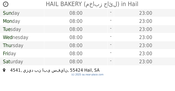
HAIL BAKERY (مخابز حائل)
4541 يزيد بن ابى سفيان, Hail
Food
read more
1.579 km
King juices
3926 Uqdah Road, Hail
Food
read more
1.996 km
Black Light
King Abdulaziz Road, Hail
Food
read more
2.052 km
Coffee Roasters Senate
8504 Al Amir Sultan Ibn Abdul Aziz, Hail
Food
read more
2.098 km
الوادي للمياه الصحيه
Hail
Food
read more
2.157 km
محامص ومطاحن الفلاج
8386 Al Amir Sultan Ibn Abdul Aziz, Hail
Food
read more
2.231 km
Konafa Day
المتنبي, Hail
Food
read more
2.249 km
Juice taste
4166, Hail
Food
read more
2.274 km
Murano sweets 2 حلويات مورانو
المطار،
Food
read more
2.276 km
Mango world
4189 Al Matar Hail 55421 7979
Food
read more
2.291 km
Al Kunafany
المتنبي, Hail
Food
read more
2.307 km
ستيب steep
4031, Hail
Food
read more
📑
all categories
Accounting
Administrative area level 1
Airport
Amusement park
Aquarium
Art gallery
Atm
Bakery
Bank
Bar
Beauty salon
Bicycle store
Book store
Bowling alley
Bus station
Cafe
Campground
Car dealer
Car rental
Car repair
Car wash
Casino
Cemetery
Church
City hall
Clothing store
Colloquial area
Convenience store
Country
Courthouse
Dentist
Department store
Doctor
Electrician
Electronics store
Embassy
Finance
Fire station
Florist
Food
Funeral home
Furniture store
Gas station
General contractor
Grocery or supermarket
Gym
Hair care
Hardware store
Health
Hindu Temple
Home goods store
Hospital
Insurance agency
Intersection
Jewelry store
Laundry
Lawyer
Library
Light rail station
Liquor store
Local government office
Locality
Locksmith
Lodging
Meal delivery
Meal takeaway
Mosque
Movie rental
Movie theater
Moving company
Museum
Natural feature
Neighborhood
Night club
Painter
Park
Parking
Pet store
Pharmacy
Physiotherapist
Place of worship
Plumber
Point of interest
Police
Political
Post office
Premise
Real estate agency
Restaurant
Roofing contractor
Route
Rv park, camping
School
Shoe store
Shopping mall
Spa
Stadium
Storage
Store
Sublocality
Subpremise
Subway station
Supermarket
Taxi stand
Train station
Transit station
Travel agency
University
Veterinary care
Zoo
sublocality level 1
↑