Gas station nearby الحربي ابو فهد
Coronavirus disease (COVID-19) Situation
confirmed cases
841469
deaths
9646
Saudi Arabia
Gas station nearby الحربي ابو فهد
الحربي ابو فهد
Jeddah Saudi Arabia
contacts phone
:
+966
Latitude:
21.814773
, Longitude:
39.2158599
read more
nearest Gas station
3.178 km
Jeddah petrol station
طريق عسفان, Jeddah
Gas station
read more
3.915 km
محطة الوليد
Jeddah
Gas station
read more
4.273 km
Station glamorous life
Jeddah
Gas station
read more
4.485 km
محطة الزهراني
8582, حي الفلاح،, Jeddah
Gas station
read more
4.967 km
المركز الاول لخدمة الاطارات وميزان السيارات
2135 حي الصالحية جدة 23763
Gas station
read more
5.007 km
محطة الأمل
7443, حي الفلاح، 4230, Jeddah
Gas station
read more
5.288 km
Teleport plane
Al Falah District, 6652, Jeddah
Gas station
read more
5.46 km
Al-Saeed Gas Station محطة السعيد
Jeddah
Gas station
read more
5.492 km
Tamim station
23762, Jeddah
Gas station
read more
5.5 km
Petromin Petrol Pump
8284, حي الحمدانية،, Jeddah
Gas station
read more
5.904 km
محطة التوريد
7195, حي الصالحية، 2396, Jeddah
Gas station
read more
6.062 km
محطة الدريس
Jeddah
Gas station
read more
6.062 km
Aldrees
Jeddah
Gas station
read more
6.119 km
محطة الفلاح
7007, حي الحمدانية, Jeddah
Gas station
read more
6.435 km
Al Tasaan Cars
6696, حي الصالحية،, Jeddah
Gas station
read more
6.531 km
Manna Station
285, Jeddah
Gas station
read more
6.554 km
University station
Jeddah
Gas station
read more
6.56 km
محطة المجد الحديثه
3642, حي الحمدانية، 7316, Jeddah
Gas station
read more
6.809 km
Petroluck Gas station
Jeddah
Gas station
read more
7.188 km
Hamdania Station
3669, حي الحمدانية, Jeddah
Gas station
read more
7.286 km
محطة الهدى للمحروقات
6824, Al Hamadaniyah District, Jeddah
Gas station
read more
7.408 km
محطة السلمي
Jeddah
Gas station
read more
7.843 km
Salama Station
معاوية بن عبدالله, Jeddah
Gas station
read more
7.882 km
بترومين اكسبرس
4673, Taibah District, Jeddah
Gas station
read more
7.942 km
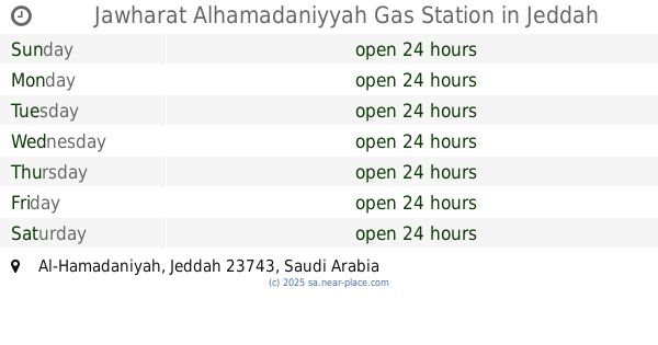
Jawharat Alhamadaniyyah Gas Station
Jeddah
Gas station
read more
📑
all categories
Accounting
Administrative area level 1
Airport
Amusement park
Aquarium
Art gallery
Atm
Bakery
Bank
Bar
Beauty salon
Bicycle store
Book store
Bowling alley
Bus station
Cafe
Campground
Car dealer
Car rental
Car repair
Car wash
Casino
Cemetery
Church
City hall
Clothing store
Colloquial area
Convenience store
Country
Courthouse
Dentist
Department store
Doctor
Electrician
Electronics store
Embassy
Finance
Fire station
Florist
Food
Funeral home
Furniture store
Gas station
General contractor
Grocery or supermarket
Gym
Hair care
Hardware store
Health
Hindu Temple
Home goods store
Hospital
Insurance agency
Intersection
Jewelry store
Laundry
Lawyer
Library
Light rail station
Liquor store
Local government office
Locality
Locksmith
Lodging
Meal delivery
Meal takeaway
Mosque
Movie rental
Movie theater
Moving company
Museum
Natural feature
Neighborhood
Night club
Painter
Park
Parking
Pet store
Pharmacy
Physiotherapist
Place of worship
Plumber
Point of interest
Police
Political
Post office
Premise
Real estate agency
Restaurant
Roofing contractor
Route
Rv park, camping
School
Shoe store
Shopping mall
Spa
Stadium
Storage
Store
Sublocality
Subpremise
Subway station
Supermarket
Taxi stand
Train station
Transit station
Travel agency
University
Veterinary care
Zoo
sublocality level 1
↑