Gas station nearby Gas Station
Saudi Arabia
Gas station nearby Gas Station
Gas Station
Al Khubaybiyyah, 52357, Buraydah, SA Saudi Arabia
contacts phone
:
+966
Latitude:
26.3249652
, Longitude:
43.9282724
larger map & directions
read more
nearest Gas station
983 m
Gas Station
Al Khubaybiyyah, Buraydah
Gas station
read more
1.124 km
محطة العطيفي للخدمات البتروليه
طريق الملك فيصل، حي خب البريدي، بريدة
Gas station
read more
1.125 km
Al Daraa Gas Station
King Faisal Road, Buraydah
Gas station
read more
1.167 km
النايف لحفر الابار
Buraydah
Gas station
read more
1.54 km
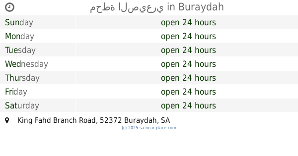
محطة الصيعري
King Fahd Branch Road, Buraydah
Gas station
read more
2.137 km
Petrol station
6960 Al Huwailan, Buraydah
Gas station
read more
2.211 km
محطة للوقود
4006, 7739, Buraydah
Gas station
read more
2.249 km
محطة وقود
6992 Prince Faisal Ibn Mishaal Ibn Saud Road, Buraydah
Gas station
read more
2.333 km
Red station
Buraydah
Gas station
read more
2.455 km
محطة برزه
2061 Prince Faisal Ibn Mishaal Ibn Saud Road, Buraydah
Gas station
read more
2.455 km
محطة البصير
2061 Prince Faisal Ibn Mishaal Ibn Saud Road, Buraydah
Gas station
read more
2.459 km
محطة أحمد فهد الغانم
Prince Faisal Ibn Mishaal Ibn Saud Road, Buraydah
Gas station
read more
2.545 km
Gas Station
Al Hamr Road, Buraydah
Gas station
read more
2.667 km
محطة محروقات
2972 طريق الحمر، مشعل بريدة 52372
Gas station
read more
2.681 km
Bilal Station
طريق الحمر Al Hamr Road, Buraydah
Gas station
read more
2.709 km
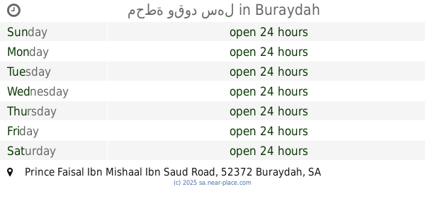
محطة وقود سهل
Prince Faisal Ibn Mishaal Ibn Saud Road, Buraydah
Gas station
read more
2.722 km
محطة السيف
Al Huwailan, Buraydah
Gas station
read more
2.818 km
محطة وقود
بريدة
Gas station
read more
2.843 km
محطة المبارك للمحروقات والقاز
بريدة
Gas station
read more
2.846 km
Kaz station
2510 Al Hamr Road, Buraydah
Gas station
read more
2.982 km
Petrol Station
Prince Faisal Ibn Mishaal Ibn Saud Road, Buraydah
Gas station
read more
2.992 km
محطة وقود البشر
Buraydah
Gas station
read more
3.024 km
محطة وقود
2190, 7818, Buraydah
Gas station
read more
3.146 km
Hamra Gas Station
Al Qanat, Buraydah
Gas station
read more
3.19 km
قطع غيار بريده
بريدة
Gas station
read more
📑
all categories
Accounting
Administrative area level 1
Airport
Amusement park
Aquarium
Art gallery
Atm
Bakery
Bank
Bar
Beauty salon
Bicycle store
Book store
Bowling alley
Bus station
Cafe
Campground
Car dealer
Car rental
Car repair
Car wash
Casino
Cemetery
Church
City hall
Clothing store
Colloquial area
Convenience store
Country
Courthouse
Dentist
Department store
Doctor
Electrician
Electronics store
Embassy
Finance
Fire station
Florist
Food
Funeral home
Furniture store
Gas station
General contractor
Grocery or supermarket
Gym
Hair care
Hardware store
Health
Hindu Temple
Home goods store
Hospital
Insurance agency
Intersection
Jewelry store
Laundry
Lawyer
Library
Light rail station
Liquor store
Local government office
Locality
Locksmith
Lodging
Meal delivery
Meal takeaway
Mosque
Movie rental
Movie theater
Moving company
Museum
Natural feature
Neighborhood
Night club
Painter
Park
Parking
Pet store
Pharmacy
Physiotherapist
Place of worship
Plumber
Point of interest
Police
Political
Post office
Premise
Real estate agency
Restaurant
Roofing contractor
Route
Rv park, camping
School
Shoe store
Shopping mall
Spa
Stadium
Storage
Store
Sublocality
Subpremise
Subway station
Supermarket
Taxi stand
Train station
Transit station
Travel agency
University
Veterinary care
Zoo
sublocality level 1
↑