Gas station nearby مغسلة بتروعدله
Saudi Arabia
Gas station nearby مغسلة بتروعدله
مغسلة بتروعدله
ضاحية الملك فهد،، King Fahd Suburb, Dammam 32313, Saudi Arabia
contacts phone
:
+966
Latitude:
26.3974939
, Longitude:
50.0166867
larger map & directions
read more
nearest Gas station
31 m
Petro Edlah
Dammam
Gas station
read more
38 m
محطة بترو عدله
Dammam
Gas station
read more
48 m
السلام لسيارات
Unnamed Road, Dammam
Gas station
read more
56 m
فيدلم لخدمات السيارات والعزل الحراري Vedlem
Showrooms Street, Dammam
Gas station
read more
196 m
محطة العسكر
95, Dammam
Gas station
read more
276 m
محطة شازكو 2
Dammam
Gas station
read more
431 m
Qarni Gas Station
95, Dammam
Gas station
read more
1.065 km
Aldrees
95, Dammam
Gas station
read more
1.53 km
Drees Petroleum Services
Dammam
Gas station
read more
1.616 km
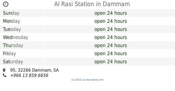
Al Rasi Station
95, Dammam
Gas station
read more
1.832 km
Tufelkhan
King Fahd Road, Dammam
Gas station
read more
2.065 km
مغسلة استعجال
المنار،, Dammam
Gas station
read more
2.137 km
Halsan station
Dammam
Gas station
read more
2.291 km
Al-Harthi Petrol Station
Abu Bakr Alsiddiq Street, Dammam
Gas station
read more
2.43 km
محطة الدريس
Unnamed Road, ضاحية الملك فهد،, Dammam
Gas station
read more
2.465 km
ALDREES Petrol Pump
Dammam
Gas station
read more
2.465 km
محطة وقود
Dammam
Gas station
read more
2.489 km
AlDrees Petrol Pump
King Fahd Road, Dammam
Gas station
read more
2.525 km
محطة بنزين الضاحيه
King Saud Street, Dammam
Gas station
read more
2.538 km
Petrol station
Dammam
Gas station
read more
2.539 km
Tarif Gulf Station
King Saud Street, Dammam
Gas station
read more
2.543 km
محطة الضاحية للوقود
Dammam
Gas station
read more
2.611 km
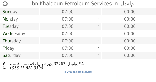
Ibn Khaldoun Petroleum Services
طريق أبو بكر الصديق، الدمام
Gas station
read more
2.623 km
محطة الصيعري
2296 الخوارزمي, 8327, Dammam
Gas station
read more
2.634 km
محطه بنزين كلينكس
Dammam
Gas station
read more
📑
all categories
Accounting
Administrative area level 1
Airport
Amusement park
Aquarium
Art gallery
Atm
Bakery
Bank
Bar
Beauty salon
Bicycle store
Book store
Bowling alley
Bus station
Cafe
Campground
Car dealer
Car rental
Car repair
Car wash
Casino
Cemetery
Church
City hall
Clothing store
Colloquial area
Convenience store
Country
Courthouse
Dentist
Department store
Doctor
Electrician
Electronics store
Embassy
Finance
Fire station
Florist
Food
Funeral home
Furniture store
Gas station
General contractor
Grocery or supermarket
Gym
Hair care
Hardware store
Health
Hindu Temple
Home goods store
Hospital
Insurance agency
Intersection
Jewelry store
Laundry
Lawyer
Library
Light rail station
Liquor store
Local government office
Locality
Locksmith
Lodging
Meal delivery
Meal takeaway
Mosque
Movie rental
Movie theater
Moving company
Museum
Natural feature
Neighborhood
Night club
Painter
Park
Parking
Pet store
Pharmacy
Physiotherapist
Place of worship
Plumber
Point of interest
Police
Political
Post office
Premise
Real estate agency
Restaurant
Roofing contractor
Route
Rv park, camping
School
Shoe store
Shopping mall
Spa
Stadium
Storage
Store
Sublocality
Subpremise
Subway station
Supermarket
Taxi stand
Train station
Transit station
Travel agency
University
Veterinary care
Zoo
sublocality level 1
↑