Gas station nearby محطة السماعيل للمحروقات
Saudi Arabia
Gas station nearby محطة السماعيل للمحروقات
محطة السماعيل للمحروقات
7582, 4840, Buraydah Saudi Arabia
contacts phone
:
+966
Latitude:
26.4346837
, Longitude:
43.8268071
read more
nearest Gas station
903 m
Petrol Station
7742, Buraydah
Gas station
read more
1.349 km
Buraidah Hail Petrol Pump
7118, Buraydah
Gas station
read more
1.422 km
بترو هلا بريدة
Buraydah
Gas station
read more
1.436 km
Patrol Station
7037 طريق الملك عبد العزيز, 3561, Buraydah
Gas station
read more
1.466 km
Al qassim has station
Buraydah
Gas station
read more
1.625 km
Sahal Gas Station
65, Buraydah
Gas station
read more
3.641 km
محطة سابك للمحروقات
4876 King Abdulaziz Road, Buraydah
Gas station
read more
3.99 km
Sahel Gas Station
3137 King Abdulaziz Road, Buraydah
Gas station
read more
4.169 km
Gas Station
7487, Buraydah
Gas station
read more
4.218 km
Gas Station
2879 King Abdulaziz Road, Buraydah
Gas station
read more
5.33 km
محطة وقود
6147, Buraydah
Gas station
read more
6.453 km
محطة الرشايدة
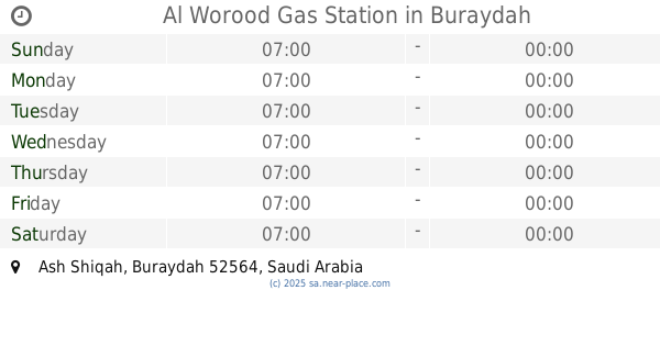
8543 Ash Shiqah, Buraydah
Gas station
read more
7.082 km
محطة الرعوجي للخدمات البتروليه
8122 الشقة بريدة 52564 3412 Ash Shiqah, Buraydah
Gas station
read more
7.176 km
محطة بشير محمد العنزي حي الشقة
الشقه، بريدة
Gas station
read more
7.178 km
Gas Station
2866, 7758, Buraydah
Gas station
read more
7.566 km
Petrol station
8503 عمر بن الخطاب, 2048, Buraydah
Gas station
read more
7.572 km
محطة نواف للخدمات البتروليه
Buraydah
Gas station
read more
7.584 km
Gas station
9165, Buraydah
Gas station
read more
7.593 km
Alma'ared Gas Station
9165, Buraydah
Gas station
read more
7.644 km
Al Manal Gas Station
Umar Ibn Al Khatab Road, Buraydah
Gas station
read more
7.807 km
محطة وتموينات
4074 Ash Shiqah, Buraydah
Gas station
read more
7.914 km
Gas Station
Northern Ring Road, Buraydah
Gas station
read more
7.934 km
Fawzan Gas Station
شارع قرطبة, Buraydah
Gas station
read more
7.938 km
Petrol station
4972, Buraydah
Gas station
read more
8.378 km
Al Worood Gas Station
Buraydah
Gas station
read more
📑
all categories
Accounting
Administrative area level 1
Airport
Amusement park
Aquarium
Art gallery
Atm
Bakery
Bank
Bar
Beauty salon
Bicycle store
Book store
Bowling alley
Bus station
Cafe
Campground
Car dealer
Car rental
Car repair
Car wash
Casino
Cemetery
Church
City hall
Clothing store
Colloquial area
Convenience store
Country
Courthouse
Dentist
Department store
Doctor
Electrician
Electronics store
Embassy
Finance
Fire station
Florist
Food
Funeral home
Furniture store
Gas station
General contractor
Grocery or supermarket
Gym
Hair care
Hardware store
Health
Hindu Temple
Home goods store
Hospital
Insurance agency
Intersection
Jewelry store
Laundry
Lawyer
Library
Light rail station
Liquor store
Local government office
Locality
Locksmith
Lodging
Meal delivery
Meal takeaway
Mosque
Movie rental
Movie theater
Moving company
Museum
Natural feature
Neighborhood
Night club
Painter
Park
Parking
Pet store
Pharmacy
Physiotherapist
Place of worship
Plumber
Point of interest
Police
Political
Post office
Premise
Real estate agency
Restaurant
Roofing contractor
Route
Rv park, camping
School
Shoe store
Shopping mall
Spa
Stadium
Storage
Store
Sublocality
Subpremise
Subway station
Supermarket
Taxi stand
Train station
Transit station
Travel agency
University
Veterinary care
Zoo
sublocality level 1
↑