Gas station nearby محطة بن مرضاح للخدمات البترولية
Saudi Arabia
Gas station nearby محطة بن مرضاح للخدمات البترولية
محطة بن مرضاح للخدمات البترولية
5262, حي القرينية 6195, Jeddah Saudi Arabia
contacts phone
:
+966
Latitude:
21.3056792
, Longitude:
39.2583919
read more
nearest Gas station
محطة بن مرضاح للخدمات البترولية
5262, حي القرينية, Jeddah
Gas station
read more
6 m
محطة بن مرضاح
5262, حي القرينية, Jeddah
Gas station
read more
7 m
محطة بن مرضاح
Jeddah
Gas station
read more
7 m
محطة ابن مرضاح
5262, حي القرينية 6195, Jeddah
Gas station
read more
263 m
Bin Suryan
5, Jeddah
Gas station
read more
1.517 km
محطة المناره للمحروقات
Jeddah
Gas station
read more
1.941 km
Pioneers Station Petroleum Services
3265, حي القرينية،, Jeddah
Gas station
read more
1.973 km
عجلاتي الخير
3253 حي القرينية جدة 22624
Gas station
read more
1.982 km
عجلاتي الخير الخمرة
Jeddah
Gas station
read more
2.128 km
Sakab محطة بترومين الخمرة
5393, حي القرينية 8242, Jeddah
Gas station
read more
2.135 km
Pouring station
حي القرينية، 5429, Jeddah
Gas station
read more
2.489 km
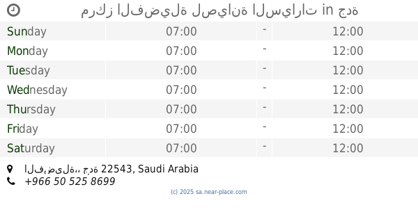
محطة الفضيله
Jeddah
Gas station
read more
2.489 km
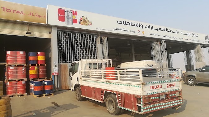
مركز الفضيلة لصيانة السيارات
جدة
Gas station
read more
2.489 km
Elite Center Oils & Tires and batteries
Unnamed Road, Jeddah
Gas station
read more
2.492 km
محطة بنزين الفضيلة
Jeddah
Gas station
read more
2.54 km
محطة فال للوقود
حي القرينية، 4295, Jeddah
Gas station
read more
3.227 km
محطة الموعد
Jeddah
Gas station
read more
4.071 km
عجلاتي مكة
Unnamed Road, Jeddah
Gas station
read more
5.186 km
Silver Sands Est. - Weast Removal Containers Services
7243, As Sarawat District 3237, Jeddah
Gas station
read more
5.266 km
مسجد الانصاري
جدة
Gas station
read more
6.878 km
CENWH
طريق الملك فيصل, Jeddah
Gas station
read more
7.59 km
محطة رواد الانجاز
Jeddah
Gas station
read more
7.635 km
محطة النورس
Jeddah
Gas station
read more
7.953 km
Bin sariyan Petrol pump
Al Khumrah، جدة
Gas station
read more
8.409 km
محطة وقود
جدة
Gas station
read more
📑
all categories
Accounting
Administrative area level 1
Airport
Amusement park
Aquarium
Art gallery
Atm
Bakery
Bank
Bar
Beauty salon
Bicycle store
Book store
Bowling alley
Bus station
Cafe
Campground
Car dealer
Car rental
Car repair
Car wash
Casino
Cemetery
Church
City hall
Clothing store
Colloquial area
Convenience store
Country
Courthouse
Dentist
Department store
Doctor
Electrician
Electronics store
Embassy
Finance
Fire station
Florist
Food
Funeral home
Furniture store
Gas station
General contractor
Grocery or supermarket
Gym
Hair care
Hardware store
Health
Hindu Temple
Home goods store
Hospital
Insurance agency
Intersection
Jewelry store
Laundry
Lawyer
Library
Light rail station
Liquor store
Local government office
Locality
Locksmith
Lodging
Meal delivery
Meal takeaway
Mosque
Movie rental
Movie theater
Moving company
Museum
Natural feature
Neighborhood
Night club
Painter
Park
Parking
Pet store
Pharmacy
Physiotherapist
Place of worship
Plumber
Point of interest
Police
Political
Post office
Premise
Real estate agency
Restaurant
Roofing contractor
Route
Rv park, camping
School
Shoe store
Shopping mall
Spa
Stadium
Storage
Store
Sublocality
Subpremise
Subway station
Supermarket
Taxi stand
Train station
Transit station
Travel agency
University
Veterinary care
Zoo
sublocality level 1
↑