Gas station nearby محطة وقود
Saudi Arabia
Gas station nearby محطة وقود
محطة وقود
شارع زين العابدين،, 32654, عنك, SA Saudi Arabia
contacts phone
:
+966
Latitude:
26.5140547
, Longitude:
49.9838692
larger map & directions
read more
nearest Gas station
21 m
محطة وقود الرايه
3225, الامام زين العابدين، الراية،, 7796, Anak
Gas station
read more
268 m
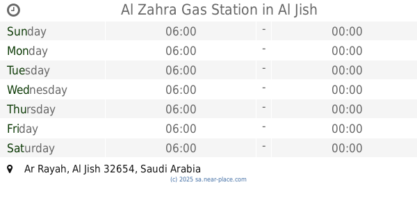
Al Zahra Gas Station
Al Jish
Gas station
read more
317 m
بترول الهادي
Anak
Gas station
read more
1.003 km
Petrol station
Dhahran Jubail Branch Road, Anak
Gas station
read more
1.234 km
Al Ganem Gas Station
Al-Malahah
Gas station
read more
1.349 km
محطة انور البراك للوقود
4110, Safwa
Gas station
read more
2.296 km
بترومين
Anak
Gas station
read more
2.313 km
East Coast Gas Station محطة الساحل الشرقي
Anak
Gas station
read more
2.594 km
محطة الهادي للمحروقات
Al Qatif
Gas station
read more
3.097 km
Aldrees
4080 طريق ابو حدرية, Safwa
Gas station
read more
3.097 km
Aldrees
95, Safwa
Gas station
read more
3.556 km
محطة وقود واحة النفط للمحروقات
7699 طريق الملك عبدالعزيز،
Gas station
read more
3.796 km
Albuainain Station
Unnamed Road, Safwa
Gas station
read more
4.007 km
Alghanim Gas Station
King Abdulaziz Road, Al Qatif
Gas station
read more
4.008 km
محطة الغانم للمحروقات
8251 King Abdulaziz Road, Al Qatif
Gas station
read more
4.042 km
Layyan Petrol Station
Saihat
Gas station
read more
4.202 km
Horse Street Station
8004 الخيل
Gas station
read more
4.203 km
al khail petrol station.محطة الخیل
8004 الخيل, Anak
Gas station
read more
4.332 km
Buraiki Station
Saihat
Gas station
read more
4.345 km
محطة بنزين
صفوى
Gas station
read more
4.351 km
Sasco
Jubail Road, Al Awjam، صفوى
Gas station
read more
4.42 km
Saudi gas station
Al Qismah Street, Anak
Gas station
read more
4.423 km
Senan Station
6649 الملك فيصل بن عبد العزيز, Al Qatif
Gas station
read more
4.556 km
Lpg Gas Cylinder Seller
Khalid Ibn Al Walid Street, 7916-7708, Anak
Gas station
read more
4.557 km
الدريس
King Abdulaziz Road, Saihat
Gas station
read more
📑
all categories
Accounting
Administrative area level 1
Airport
Amusement park
Aquarium
Art gallery
Atm
Bakery
Bank
Bar
Beauty salon
Bicycle store
Book store
Bowling alley
Bus station
Cafe
Campground
Car dealer
Car rental
Car repair
Car wash
Casino
Cemetery
Church
City hall
Clothing store
Colloquial area
Convenience store
Country
Courthouse
Dentist
Department store
Doctor
Electrician
Electronics store
Embassy
Finance
Fire station
Florist
Food
Funeral home
Furniture store
Gas station
General contractor
Grocery or supermarket
Gym
Hair care
Hardware store
Health
Hindu Temple
Home goods store
Hospital
Insurance agency
Intersection
Jewelry store
Laundry
Lawyer
Library
Light rail station
Liquor store
Local government office
Locality
Locksmith
Lodging
Meal delivery
Meal takeaway
Mosque
Movie rental
Movie theater
Moving company
Museum
Natural feature
Neighborhood
Night club
Painter
Park
Parking
Pet store
Pharmacy
Physiotherapist
Place of worship
Plumber
Point of interest
Police
Political
Post office
Premise
Real estate agency
Restaurant
Roofing contractor
Route
Rv park, camping
School
Shoe store
Shopping mall
Spa
Stadium
Storage
Store
Sublocality
Subpremise
Subway station
Supermarket
Taxi stand
Train station
Transit station
Travel agency
University
Veterinary care
Zoo
sublocality level 1
↑