Gas station nearby Petrol Pump التسهيلات
Saudi Arabia
Gas station nearby Petrol Pump التسهيلات
Petrol Pump التسهيلات
Al Adamah, Dammam 32242, Saudi Arabia
contacts phone
:
+966
Latitude:
26.4326091
, Longitude:
50.0975087
larger map & directions
read more
nearest Gas station
9 m
محطة سهل
الدمام
Gas station
read more
237 m
Petroly Gas Station
18th Street, Dammam
Gas station
read more
422 m
Kia
Dammam
Gas station
read more
448 m
Qathami for the sale and distribution of gas
7857 17, Dammam
Gas station
read more
699 m
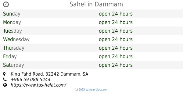
Sahel
King Fahd Road, Dammam
Gas station
read more
744 m
محطة ستار الساطع
11th Street, Dammam
Gas station
read more
746 m
Gas Station
7635 الحادي عشر, Dammam
Gas station
read more
971 m
ENOC
2647 King Khaled Street, Dammam
Gas station
read more
974 m
Aldrees
2601 المستشفى, Dammam
Gas station
read more
1.006 km
محطة شارع البريد
9th Street, Dammam
Gas station
read more
1.086 km
Naft
2552 King Khaled Street, Dammam
Gas station
read more
1.298 km
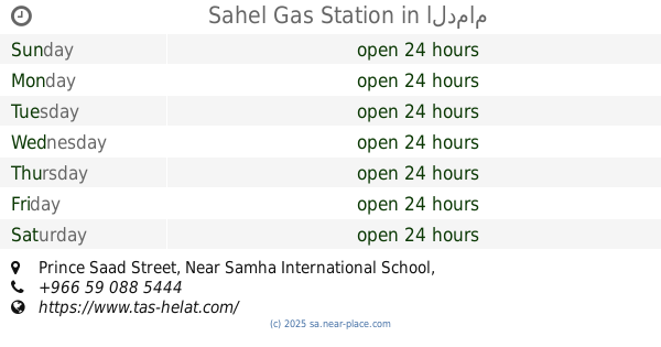
Sahel Gas Station
Prince Saad Street, Near Samha International School، الدمام
Gas station
read more
1.312 km
ساسكو
King Saud Street, Dammam
Gas station
read more
1.355 km
Sahel
Othman Ibn Affan Street, Dammam
Gas station
read more
1.46 km
Al Dammam Station
Dammam
Gas station
read more
1.491 km
SASCO Palm
28th Street, Al Mazara St., Dammam
Gas station
read more
1.585 km
jubail fm
Dammam
Gas station
read more
1.701 km
Al Drees Petrol Station
Dammam
Gas station
read more
1.709 km
غيار زيت حقت سكيكو
6334 17, Dammam
Gas station
read more
1.82 km
Al Drees Gas Station
Dammam
Gas station
read more
1.836 km
محطة بترومين
32253, Dammam
Gas station
read more
1.838 km
سطحةداخل الدمام
الدمام
Gas station
read more
1.847 km
Sasco Gas Station
2510 عثمان بن عفان, 7402, Dammam
Gas station
read more
1.848 km
محطة المرتفعات الشرقية
2510 عثمان بن عفان, Dammam
Gas station
read more
1.904 km
Al Ozone Petrol pump
5364 الملك خالد, Dammam
Gas station
read more
📑
all categories
Accounting
Administrative area level 1
Airport
Amusement park
Aquarium
Art gallery
Atm
Bakery
Bank
Bar
Beauty salon
Bicycle store
Book store
Bowling alley
Bus station
Cafe
Campground
Car dealer
Car rental
Car repair
Car wash
Casino
Cemetery
Church
City hall
Clothing store
Colloquial area
Convenience store
Country
Courthouse
Dentist
Department store
Doctor
Electrician
Electronics store
Embassy
Finance
Fire station
Florist
Food
Funeral home
Furniture store
Gas station
General contractor
Grocery or supermarket
Gym
Hair care
Hardware store
Health
Hindu Temple
Home goods store
Hospital
Insurance agency
Intersection
Jewelry store
Laundry
Lawyer
Library
Light rail station
Liquor store
Local government office
Locality
Locksmith
Lodging
Meal delivery
Meal takeaway
Mosque
Movie rental
Movie theater
Moving company
Museum
Natural feature
Neighborhood
Night club
Painter
Park
Parking
Pet store
Pharmacy
Physiotherapist
Place of worship
Plumber
Point of interest
Police
Political
Post office
Premise
Real estate agency
Restaurant
Roofing contractor
Route
Rv park, camping
School
Shoe store
Shopping mall
Spa
Stadium
Storage
Store
Sublocality
Subpremise
Subway station
Supermarket
Taxi stand
Train station
Transit station
Travel agency
University
Veterinary care
Zoo
sublocality level 1
↑