Gym nearby نادي فيت يو | Fit You
Saudi Arabia
Gym nearby نادي فيت يو | Fit You
نادي فيت يو | Fit You
السويدي الغربي،, Riyadh Saudi Arabia
contacts phone
:
+966
Latitude:
24.566522
, Longitude:
46.624688
read more
nearest Gym
200 m
مركز روعة الاسترخاء
Riyadh
Gym
read more
358 m
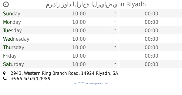
مركز رواد الراحة الرياضي
2943 Western Ring Branch Road, Riyadh
Gym
read more
358 m
مركز رواد الراحة الرياضي
2943 Western Ring Branch Rd, Riyadh
Gym
read more
503 m
مركز روعة الراحة الرياضي للمساج
Riyadh
Gym
read more
649 m
نادي الظهران
مخرج ٢٧
Gym
read more
675 m
ممشئ الفريان
4658 الطريق الدائري الغربي الفرعي،, 6494, Riyadh
Gym
read more
915 m
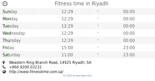
Fitness time
Western Ring Branch Road, Riyadh
Gym
read more
915 m
Fitness time
Weastern Ring Branch Road, Riyadh
Gym
read more
1.133 km
Fitness Code
Riyadh
Gym
read more
1.196 km
مركز فرسان الراحه {{للمساااج والحمام المغربي}}
Riyadh
Gym
read more
1.204 km
مركز الرشاقه
السويدي الغربي،, Riyadh
Gym
read more
1.315 km
شاليهات امواج - Amoaj Resort
Riyadh
Gym
read more
1.599 km
Dr.nutrition ، DNP ، دكتور نيوترشن لتخسيس الوزن اغذية الحمية ،
Riyadh
Gym
read more
1.896 km
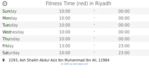
Fitness Time (red)
2293 Ash Shaikh Abdul Aziz Ibn Muhammad Ibn Ali, Riyadh
Gym
read more
2.1 km
مركز بدن للمساج والحمام المغربي
3790 المدينة المنورة, 6562, Riyadh
Gym
read more
2.15 km
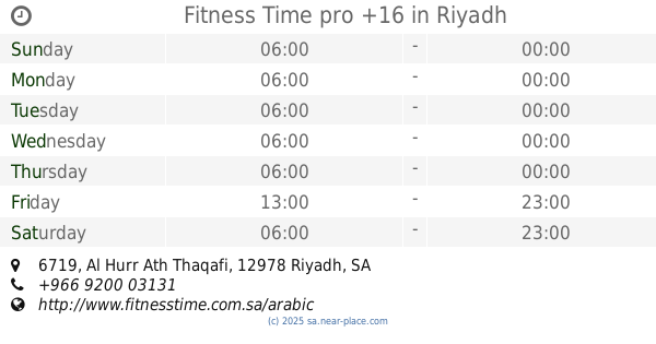
Fitness Time pro +16
6719 Al Hurr Ath Thaqafi, Riyadh
Gym
read more
2.218 km
محمد مترك القحطاني
طريق المدينة المنورة،، الرياض
Gym
read more
2.395 km
9Round
3890 Southern Ring Branch Road, Riyadh
Gym
read more
2.74 km
Power Man Club الرجل القوي
3297 Bashir Ibn Al Walid, Riyadh
Gym
read more
2.743 km
The man strong athletic center
Riyadh
Gym
read more
2.782 km
Sports Center magnificence of my feet
4050 الطريق الدائري الجنوبي الفرعي، شبرا الرياض 12989 6472 Southern Ring Branch Road, Riyadh
Gym
read more
3.485 km
Duck football pitches football
Riyadh
Gym
read more
3.485 km
Body Masters
Ibn Al Jauzi, Riyadh
Gym
read more
3.563 km
أكاديمية العاصمة
الرياض
Gym
read more
3.59 km
نطيطات وزحاليق وملاعب صابونيه
Ziad Al Bahli Street, Riyadh
Gym
read more
📑
all categories
Accounting
Administrative area level 1
Airport
Amusement park
Aquarium
Art gallery
Atm
Bakery
Bank
Bar
Beauty salon
Bicycle store
Book store
Bowling alley
Bus station
Cafe
Campground
Car dealer
Car rental
Car repair
Car wash
Casino
Cemetery
Church
City hall
Clothing store
Colloquial area
Convenience store
Country
Courthouse
Dentist
Department store
Doctor
Electrician
Electronics store
Embassy
Finance
Fire station
Florist
Food
Funeral home
Furniture store
Gas station
General contractor
Grocery or supermarket
Gym
Hair care
Hardware store
Health
Hindu Temple
Home goods store
Hospital
Insurance agency
Intersection
Jewelry store
Laundry
Lawyer
Library
Light rail station
Liquor store
Local government office
Locality
Locksmith
Lodging
Meal delivery
Meal takeaway
Mosque
Movie rental
Movie theater
Moving company
Museum
Natural feature
Neighborhood
Night club
Painter
Park
Parking
Pet store
Pharmacy
Physiotherapist
Place of worship
Plumber
Point of interest
Police
Political
Post office
Premise
Real estate agency
Restaurant
Roofing contractor
Route
Rv park, camping
School
Shoe store
Shopping mall
Spa
Stadium
Storage
Store
Sublocality
Subpremise
Subway station
Supermarket
Taxi stand
Train station
Transit station
Travel agency
University
Veterinary care
Zoo
sublocality level 1
↑