Gym nearby راوند ون
Saudi Arabia
Gym nearby راوند ون
راوند ون
طريق ديراب الفرعي،، الرياض Saudi Arabia
contacts phone
:
+966
Latitude:
24.5343704
, Longitude:
46.6553474
read more
nearest Gym
946 m
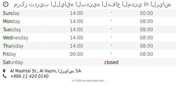
مركز تدريب اللياقه البدنيه الدفاع المدني
Al Mashtal St., Al Hazm، الرياض
Gym
read more
985 m
إدارة مطابع الدفاع المدني
4648 Hamzah Ibn Abdul Mutalib, Riyadh
Gym
read more
1.097 km
مركز تدريب اللياقة البدنية والنشاط الرياضي بالدفاع المدني
Riyadh
Gym
read more
1.339 km
Golf professional
8748 Al Quaimiyah, Riyadh
Gym
read more
1.678 km
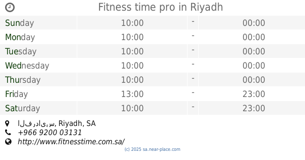
Fitness time pro
Bulding 3, الفردايس, Riyadh
Gym
read more
1.687 km
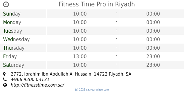
Fitness Time Pro
2772 Ibrahim Ibn Abdullah Al Hussain, Riyadh
Gym
read more
1.757 km
رواد الراحة الرياضي
8409 طريق ديراب الفرعي، المروة، الرياض 14722 2854 Dirab Branch Rd, 14722 2854, Riyadh
Gym
read more
1.76 km
مساج ساعة الراحة
Riyadh
Gym
read more
1.926 km
ابو مشهور
Riyadh
Gym
read more
2.68 km
Duck football pitches football
Riyadh
Gym
read more
2.982 km
Vital
Dirab Road, Riyadh
Gym
read more
3.214 km
Dr.nutrition ، DNP ، دكتور نيوترشن لتخسيس الوزن اغذية الحمية ،
Riyadh
Gym
read more
3.282 km
Shifa courts
4895, Riyadh
Gym
read more
3.303 km
Playgrounds healing Ibn Taymiyya
4907, Riyadh
Gym
read more
3.337 km
9Round
3890 Southern Ring Branch Road, Riyadh
Gym
read more
3.56 km
Sports Center magnificence of my feet
4050 الطريق الدائري الجنوبي الفرعي، شبرا الرياض 12989 6472 Southern Ring Branch Road, Riyadh
Gym
read more
3.842 km
ملعب القلعه
3049, Riyadh
Gym
read more
3.934 km
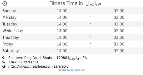
Fitness Time
Southern Ring Road, Shubra، الرياض
Gym
read more
4.178 km
ممشئ الفريان
4658 الطريق الدائري الغربي الفرعي،, 6494, Riyadh
Gym
read more
4.255 km
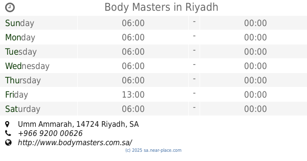
Body Masters
Umm Ammarah, Riyadh
Gym
read more
4.28 km
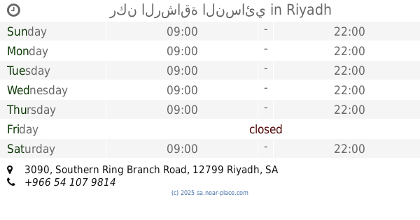
ركن الرشاقة النسائي
3090 Southern Ring Branch Road, Riyadh
Gym
read more
4.294 km
9Round
Dirab Branch Road, Riyadh
Gym
read more
4.299 km
مركز روعة الراحة الرياضي للمساج
Riyadh
Gym
read more
4.312 km
Fitness Code
Riyadh
Gym
read more
4.51 km
مركز الرشاقه
السويدي الغربي،, Riyadh
Gym
read more
📑
all categories
Accounting
Administrative area level 1
Airport
Amusement park
Aquarium
Art gallery
Atm
Bakery
Bank
Bar
Beauty salon
Bicycle store
Book store
Bowling alley
Bus station
Cafe
Campground
Car dealer
Car rental
Car repair
Car wash
Casino
Cemetery
Church
City hall
Clothing store
Colloquial area
Convenience store
Country
Courthouse
Dentist
Department store
Doctor
Electrician
Electronics store
Embassy
Finance
Fire station
Florist
Food
Funeral home
Furniture store
Gas station
General contractor
Grocery or supermarket
Gym
Hair care
Hardware store
Health
Hindu Temple
Home goods store
Hospital
Insurance agency
Intersection
Jewelry store
Laundry
Lawyer
Library
Light rail station
Liquor store
Local government office
Locality
Locksmith
Lodging
Meal delivery
Meal takeaway
Mosque
Movie rental
Movie theater
Moving company
Museum
Natural feature
Neighborhood
Night club
Painter
Park
Parking
Pet store
Pharmacy
Physiotherapist
Place of worship
Plumber
Point of interest
Police
Political
Post office
Premise
Real estate agency
Restaurant
Roofing contractor
Route
Rv park, camping
School
Shoe store
Shopping mall
Spa
Stadium
Storage
Store
Sublocality
Subpremise
Subway station
Supermarket
Taxi stand
Train station
Transit station
Travel agency
University
Veterinary care
Zoo
sublocality level 1
↑