Gym nearby School district complex activities Ballit
Saudi Arabia
Gym nearby School district complex activities Ballit
School district complex activities Ballit
شارع المستشفى, 28434, Al Lith, SA Saudi Arabia
contacts phone
:
+966
Latitude:
20.1479738
, Longitude:
40.2727595
larger map & directions
read more
nearest Gym
44 m
نادي الحي بالليث
Al Lith
Gym
read more
344 m
الثانوية الاولى بالليث
Al Lith
Gym
read more
110.685 km
مقهى وجلسات عائلية
267, Taif
Gym
read more
121.032 km
ملعب الفيفا
6918, Al Baha, الباحة
Gym
read more
121.581 km
Sport Avenue
Al Khazraj, Taif
Gym
read more
122.704 km
صالة العين الرياضية
Alhojora
Gym
read more
123.35 km
ملعب قرية الأثمة
Al Bahah
Gym
read more
124.005 km
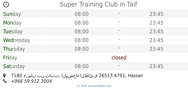
Super Training Club
7180 حسان بن ثابت، الوشحاء الطائف 26513 4791 Hassan Ibn Thabit, Taif
Gym
read more
124.737 km
سبورت افينيو
Taif
Gym
read more
124.737 km
الجادةالرياضية
الطائف
Gym
read more
125.165 km
مربط المهابة
Taif
Gym
read more
125.375 km
خطوات تمارين Exersizes Steps
Al Baladiah, Taif
Gym
read more
125.537 km
Fitness First
King Fahd Road, Al Bahah
Gym
read more
125.572 km
صالون سمو
6167 المزغدية, Taif
Gym
read more
125.627 km
استراحة الريف
Al Shaik Ibrahim Al Ibrahim St، الباحة
Gym
read more
125.776 km
نادي سوبر باور جيم
6323 Osama Ibn Ziad, Taif
Gym
read more
125.964 km
صالون مناكير (بديكير منيكير)
4020 Al Amir Mitib, 9234, Taif
Gym
read more
126.239 km
Gold's Gym
9685 Abu Bakr As Siddiq, Taif
Gym
read more
126.421 km
ملعب كرة
7013, Taif
Gym
read more
126.528 km
Fitness Time Pro
Sheikhi Saud Alsudairi, Al Bahah
Gym
read more
126.663 km
نادي سهم القوة الرياضي
6488 Al Qamariyyah, Taif
Gym
read more
126.764 km
Elite Fitness Lines
6693، القمرية، الطائف 26523
Gym
read more
126.77 km
Fitmiss | فيت ميس
7269, Taif
Gym
read more
126.881 km
مؤسسة خطوات الأبداع للتشغيل والصيانه
Unnamed Road, Taif
Gym
read more
126.881 km
Healthy Steps مركز خطوات الصحة
King Faisal Road, Taif
Gym
read more
📑
all categories
Accounting
Administrative area level 1
Airport
Amusement park
Aquarium
Art gallery
Atm
Bakery
Bank
Bar
Beauty salon
Bicycle store
Book store
Bowling alley
Bus station
Cafe
Campground
Car dealer
Car rental
Car repair
Car wash
Casino
Cemetery
Church
City hall
Clothing store
Colloquial area
Convenience store
Country
Courthouse
Dentist
Department store
Doctor
Electrician
Electronics store
Embassy
Finance
Fire station
Florist
Food
Funeral home
Furniture store
Gas station
General contractor
Grocery or supermarket
Gym
Hair care
Hardware store
Health
Hindu Temple
Home goods store
Hospital
Insurance agency
Intersection
Jewelry store
Laundry
Lawyer
Library
Light rail station
Liquor store
Local government office
Locality
Locksmith
Lodging
Meal delivery
Meal takeaway
Mosque
Movie rental
Movie theater
Moving company
Museum
Natural feature
Neighborhood
Night club
Painter
Park
Parking
Pet store
Pharmacy
Physiotherapist
Place of worship
Plumber
Point of interest
Police
Political
Post office
Premise
Real estate agency
Restaurant
Roofing contractor
Route
Rv park, camping
School
Shoe store
Shopping mall
Spa
Stadium
Storage
Store
Sublocality
Subpremise
Subway station
Supermarket
Taxi stand
Train station
Transit station
Travel agency
University
Veterinary care
Zoo
sublocality level 1
↑