Health nearby Health Care Center
Coronavirus disease (COVID-19) Situation
confirmed cases
841469
deaths
9646
Saudi Arabia
Health nearby Health Care Center
Health Care Center
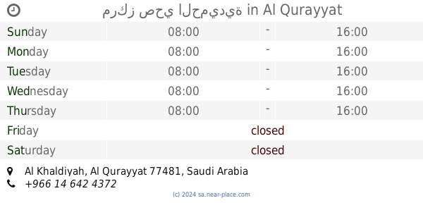
Al Qurayyat Arabia Saudita
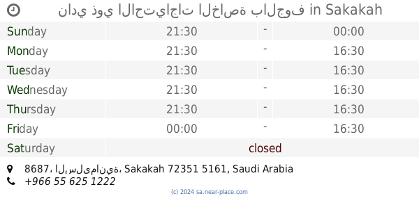
contacts phone
:
+966
Latitude:
31.3230757
, Longitude:
37.3347056
read more
nearest Health
407 m
مجمع التخصصي للأسنان والجلدية
Al Qurayyat
Health
read more
793 m
المركز الصحي لقوى الأمن
Al Qurayyat
Health
read more
1.237 km
مستوصف العجاج بالقريات
القريات
Health
read more
1.238 km
Al Ajjaj Polyclinic
Tabuk, Tabuk Street,, Al Qurayyat
Health
read more
1.44 km
مجمع الحياة الطبي
Al Qurayyat
Health
read more
1.458 km
Al Badar Clinic
Al Qurayyat
Health
read more
1.504 km
Vitamin Pharmacy
Opp. Badr Polyclinic,, Al Qurayyat
Health
read more
1.537 km
مركز صحي الحميدية
Al Qurayyat
Health
read more
2.196 km
مجمع المدينة الطبي
القريات
Health
read more
2.625 km
مركز صحي الفيصلية
Al Qurayyat
Health
read more
2.644 km
Specialized Endocrinology and Diabetes Center
Al Qurayyat
Health
read more
2.748 km
عيادة علاج الطبيعي
Al Qurayyat
Health
read more
2.791 km
Dispensary farms neighborhood
Al Qurayyat
Health
read more
2.798 km
العيادات الخارجية Out Patients clinics GGH
Al Qurayyat
Health
read more
2.8 km
Outpatient clinics العيادات الخارجية
Al Qurayyat
Health
read more
3.204 km
Dispensary Hshehadh district
Al Qurayyat
Health
read more
303.543 km
مستوصف مركز الفياض
سكاكا
Health
read more
310.561 km
نادي ذوي الاحتياجات الخاصة بالجوف
8687, Sakaka
Health
read more
311.667 km
Northern primary care center
طريق قيال, Sakaka
Health
read more
311.691 km
مستوصف الربوة
سكاكا
Health
read more
312.466 km
صيدلية الشفاء
9322 طريق الملك عبدالعزيز, 3334, Sakaka
Health
read more
312.519 km
مستوصف الحمد الطبي
الشفاء
Health
read more
312.597 km
الوحدة الصحية المدرسية للبنين
Al-Ma'aqlah
Health
read more
312.671 km
مستوصف السوق و المطر
6810, Sakaka
Health
read more
312.693 km
Al Iman Opticals Sakaka
طريق الملك عبدالعزيز, Sakaka
Health
read more
📑
all categories
Accounting
Administrative area level 1
Airport
Amusement park
Aquarium
Art gallery
Atm
Bakery
Bank
Bar
Beauty salon
Bicycle store
Book store
Bowling alley
Bus station
Cafe
Campground
Car dealer
Car rental
Car repair
Car wash
Casino
Cemetery
Church
City hall
Clothing store
Colloquial area
Convenience store
Country
Courthouse
Dentist
Department store
Doctor
Electrician
Electronics store
Embassy
Finance
Fire station
Florist
Food
Funeral home
Furniture store
Gas station
General contractor
Grocery or supermarket
Gym
Hair care
Hardware store
Health
Hindu Temple
Home goods store
Hospital
Insurance agency
Intersection
Jewelry store
Laundry
Lawyer
Library
Light rail station
Liquor store
Local government office
Locality
Locksmith
Lodging
Meal delivery
Meal takeaway
Mosque
Movie rental
Movie theater
Moving company
Museum
Natural feature
Neighborhood
Night club
Painter
Park
Parking
Pet store
Pharmacy
Physiotherapist
Place of worship
Plumber
Point of interest
Police
Political
Post office
Premise
Real estate agency
Restaurant
Roofing contractor
Route
Rv park, camping
School
Shoe store
Shopping mall
Spa
Stadium
Storage
Store
Sublocality
Subpremise
Subway station
Supermarket
Taxi stand
Train station
Transit station
Travel agency
University
Veterinary care
Zoo
sublocality level 1
↑