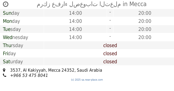
Health nearby Medical elite complex
Saudi Arabia
Health nearby Medical elite complex
Medical elite complex
6383, Ash Shawqiyyah, Mecca 24351, Saudi Arabia
contacts phone
:
+966 12 565 1611
Latitude:
21.3739246
, Longitude:
39.8008368
larger map & directions
read more
nearest Health
326 m
مجمع عيادات العيساوي
Mecca
Health
read more
400 m
مجمع بدر السماء الطبي
Mecca
Health
read more
836 m
صيدلية دواء الحجاز ابوخارجة
Mecca
Health
read more
926 m
مركز صحي الكعكية
Unnamed Road, 24353, Mecca
Health
read more
953 m
مجمع د/آمنة سعيد فلاتة الطبي المتخصص في طب العيون
5044, Mecca
Health
read more
1.188 km
المجمع الطبي الحديث العام
Ibrahim Al Khalil, Mecca
Health
read more
1.301 km
عيادات فلاته
2536, Mecca
Health
read more
1.314 km
مجمع نخبة الفايز الطبي المتخصص
الشوقية شارع المستهلك العام
Health
read more
1.368 km
Al Borg Medical Laboratories
شارع الدكتور عبدالقادر كوشك, Mecca
Health
read more
1.43 km
Dental Clinic
6804, Mecca
Health
read more
1.72 km
Jamaal Pharmacy
Mecca
Health
read more
1.79 km
مجمع عيادات خالد عبده الطبي مكة المكرمة
Al Lith Rd Al Lith Road, Mecca
Health
read more
1.845 km
مركز عفراء لصعوبات التعلم
3537, Mecca
Health
read more
1.997 km
Ghaya Pharmacy
8202 Ibrahim Al Khalil, Mecca
Health
read more
2.163 km
Al Farraj Polyclinic
8409 Abdullah Ibn Al Abbas St, Ash Shawqiyyah, Mecca 24351 3445 Abdullah Ibn Al Abbas Street, Mecca
Health
read more
2.204 km
Saad Al Luqmani Pharmacy
8430, Mecca
Health
read more
2.302 km
Asian Polyclinic
Mecca
Health
read more
2.545 km
Primary Health Care Center
3941 3rd Ring Road, Mecca
Health
read more
2.614 km
مركز إسعاف بطحاء قريش
6659, Mecca
Health
read more
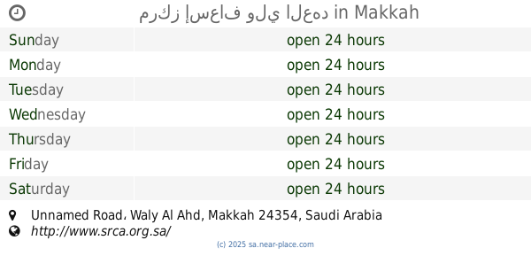
2.659 km
مركز إسعاف ولي العهد
Unnamed Road, Mecca
Health
read more
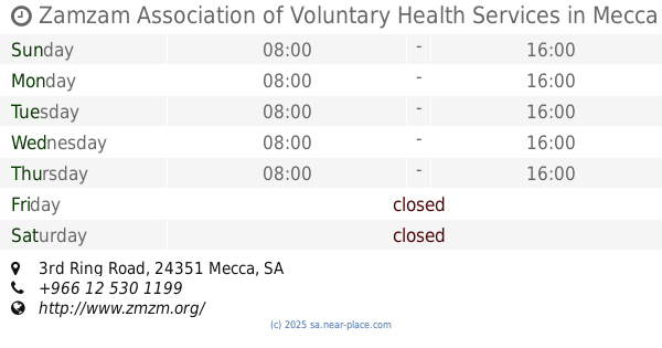
2.702 km
Zamzam Association of Voluntary Health Services
3rd Ring Road, Mecca
Health
read more
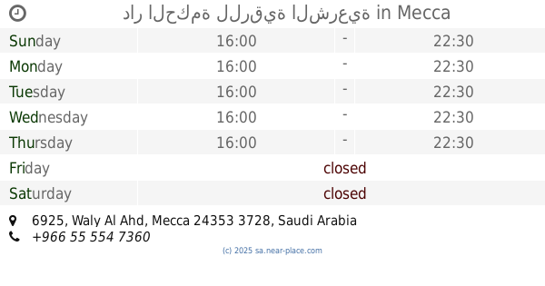
2.849 km
دار الحكمة للرقية الشرعية
6925, Mecca
Health
read more
3.005 km
Kudai Red Crescent First Aid Centre
Mecca
Health
read more
3.063 km
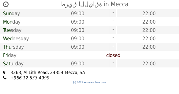
طريق اللياقة
3363 Al Lith Road, 7821, Mecca
Health
read more
3.131 km
مركز إسعاف الخالدية
Mecca
Health
read more
📑
all categories
Accounting
Administrative area level 1
Airport
Amusement park
Aquarium
Art gallery
Atm
Bakery
Bank
Bar
Beauty salon
Bicycle store
Book store
Bowling alley
Bus station
Cafe
Campground
Car dealer
Car rental
Car repair
Car wash
Casino
Cemetery
Church
City hall
Clothing store
Colloquial area
Convenience store
Country
Courthouse
Dentist
Department store
Doctor
Electrician
Electronics store
Embassy
Finance
Fire station
Florist
Food
Funeral home
Furniture store
Gas station
General contractor
Grocery or supermarket
Gym
Hair care
Hardware store
Health
Hindu Temple
Home goods store
Hospital
Insurance agency
Intersection
Jewelry store
Laundry
Lawyer
Library
Light rail station
Liquor store
Local government office
Locality
Locksmith
Lodging
Meal delivery
Meal takeaway
Mosque
Movie rental
Movie theater
Moving company
Museum
Natural feature
Neighborhood
Night club
Painter
Park
Parking
Pet store
Pharmacy
Physiotherapist
Place of worship
Plumber
Point of interest
Police
Political
Post office
Premise
Real estate agency
Restaurant
Roofing contractor
Route
Rv park, camping
School
Shoe store
Shopping mall
Spa
Stadium
Storage
Store
Sublocality
Subpremise
Subway station
Supermarket
Taxi stand
Train station
Transit station
Travel agency
University
Veterinary care
Zoo
sublocality level 1
↑