Health nearby محل إبراهيم الجامع للعطارة
Saudi Arabia
Health nearby محل إبراهيم الجامع للعطارة
محل إبراهيم الجامع للعطارة
2899, بدر, 32636, Al Qatif, SA Saudi Arabia
contacts phone
:
+966 13 855 1340
Latitude:
26.5550223
, Longitude:
50.0055794
larger map & directions
read more
nearest Health
255 m
Al Wazzan Vision Qatif Khunaizi
القطيف
Health
read more
561 m
Health Center Qatif 3
Al Qatif
Health
read more
583 m
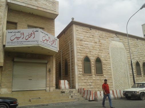
Ahl Al Bait Office for General Services
7584 King Abdulaziz Road, Al Qatif
Health
read more
808 m
Shwiakah PHC
King Abdulaziz Road, Al Qatif
Health
read more
816 m
الرعاية الصحية
Al Qatif
Health
read more
909 m
اللجنة الصحية بالقطيف
Al Qatif
Health
read more
916 m
Medical Excellence Complex
7488 Al Quds Street, 3627, Al Qatif
Health
read more
950 m
Integration Physical Therapy Center
Al Qatif
Health
read more
1.217 km
صيدلية علاحات 2
3043, Al Qatif
Health
read more
1.384 km
Tubi PHC
Al Qatif
Health
read more
1.415 km
Almohanna pharmacies group for medical suplies
Al Qatif
Health
read more
1.42 km
المستشار القانوني محمد ابراهيم البنا
Al Qatif
Health
read more
1.571 km
Alnaji Clinic
Al Quds St Al Quds Street, Warehouse Area, Al Qatif
Health
read more
1.583 km
Majidya PHC
المجيدية، القطيف
Health
read more
1.899 km
Hillat Mahaish PHC
Al Qatif
Health
read more
2.026 km
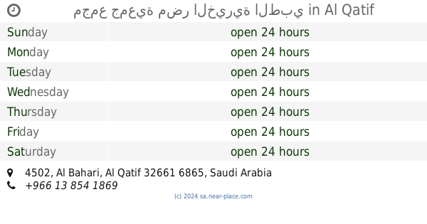
مجمع جمعية مضر الخيرية الطبي
4502, Al Qatif
Health
read more
2.033 km
المجمع الطبي لجمعية مضر الخيرية
4502, Al Qatif
Health
read more
2.035 km
Mudar Dispensary
Al Qatif
Health
read more
2.173 km
مركز رعاية المكفوفين بالقطيف
Al Qatif
Health
read more
2.215 km
Jarudia PHC
Badr Street, Al Qatif
Health
read more
2.236 km
منتجع امجد السياحي
Al Qatif
Health
read more
2.458 km
مستودع المهنا
3836, Warehouse Area,, Al Qatif
Health
read more
2.464 km
ATCo Medical Qatif KSA
3836, Warehouse Area,, Al Qatif
Health
read more
2.891 km
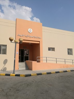
Health Care Administration of Qatif
Al Imam Ali Ibn Abi Talib Road, Al Qatif
Health
read more
3.043 km
Monira PHC
Al-Waha,، الامين البدراني، القطيف
Health
read more
📑
all categories
Accounting
Administrative area level 1
Airport
Amusement park
Aquarium
Art gallery
Atm
Bakery
Bank
Bar
Beauty salon
Bicycle store
Book store
Bowling alley
Bus station
Cafe
Campground
Car dealer
Car rental
Car repair
Car wash
Casino
Cemetery
Church
City hall
Clothing store
Colloquial area
Convenience store
Country
Courthouse
Dentist
Department store
Doctor
Electrician
Electronics store
Embassy
Finance
Fire station
Florist
Food
Funeral home
Furniture store
Gas station
General contractor
Grocery or supermarket
Gym
Hair care
Hardware store
Health
Hindu Temple
Home goods store
Hospital
Insurance agency
Intersection
Jewelry store
Laundry
Lawyer
Library
Light rail station
Liquor store
Local government office
Locality
Locksmith
Lodging
Meal delivery
Meal takeaway
Mosque
Movie rental
Movie theater
Moving company
Museum
Natural feature
Neighborhood
Night club
Painter
Park
Parking
Pet store
Pharmacy
Physiotherapist
Place of worship
Plumber
Point of interest
Police
Political
Post office
Premise
Real estate agency
Restaurant
Roofing contractor
Route
Rv park, camping
School
Shoe store
Shopping mall
Spa
Stadium
Storage
Store
Sublocality
Subpremise
Subway station
Supermarket
Taxi stand
Train station
Transit station
Travel agency
University
Veterinary care
Zoo
sublocality level 1
↑