Health nearby مـركـز دافيتا المجاردة
Saudi Arabia
Health nearby مـركـز دافيتا المجاردة
مـركـز دافيتا المجاردة
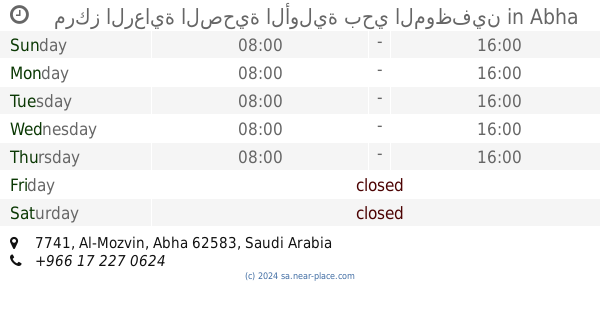
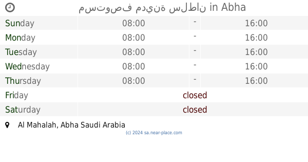
مستشفى المجارده العام, Al Mahalah, الطائف - القروى 62561, Saudi Arabia
contacts phone
:
+966 17 293 3543
website:
www.davita.com
Latitude:
18.246819
, Longitude:
42.59988
larger map & directions
read more
nearest Health
38 m
DaVita Dialysis Center - Al Majardah
Al Majardah General Hospital Badr Rd.,
Health
read more
854 m
دكتور نيوترشن
عسير مول، أبها
Health
read more
1.189 km
مركز الرعاية الصحية الأولية بحي الموظفين
3420, 7741, Abha
Health
read more
1.19 km
مركز الرعاية الصحية الأولية حي الموظفين
Abha
Health
read more
1.751 km
Medical clinic Anumeis
King Fahd Branch Road, Abha
Health
read more
1.751 km
مجمع عيادات النميص
Abha
Health
read more
3.137 km
Sultan City Health Center
8620, Abha
Health
read more
3.535 km
Saad Medical Specialized Group
King Fahd Branch Road, Abha
Health
read more
3.567 km
Nahdi
2230, Abha
Health
read more
3.912 km
Nahdi Medical Company
King Fahd Road, Abha
Health
read more
3.954 km
المعسكر الكشفي الدائم
6969, 3439, Abha
Health
read more
3.968 km
شركة الحياة الطبية - أبها AMCO
Abha
Health
read more
4.238 km
مستوصف مدينة سلطان
Abha
Health
read more
4.242 km
Primary Health Care Center
2230, Abha
Health
read more
4.292 km
الشركة الكيمائية المحدودة
Abha
Health
read more
4.367 km
Saudi Red Crescent Authority
Abha
Health
read more
4.37 km
Sultan City ambulance
Abha
Health
read more
4.411 km
Medical And Pharmacuitacal Services Company
King Fahad Road, Abha
Health
read more
4.445 km
مركز روح الإصرار للرعاية والتأهيل
Abha
Health
read more
5.082 km
Ambulance Abha Center 2
Abu Huraira Road, Abha
Health
read more
5.216 km
مركز الرواد الطبي
Abha
Health
read more
5.283 km
Abha Kuzmolayn Medical Laboratory Dr. Hamza Complex
4746, Abha
Health
read more
5.537 km
شركة زمو للتجارة المحدودة
King Fahd Branch Road, Abha
Health
read more
5.725 km
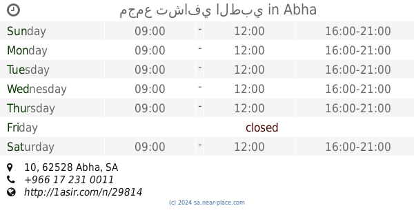
مجمع تشافي الطبي
10, Abha
Health
read more
5.896 km
Al Ertifaa Polyclinic
7864, 4279, Abha
Health
read more
📑
all categories
Accounting
Administrative area level 1
Airport
Amusement park
Aquarium
Art gallery
Atm
Bakery
Bank
Bar
Beauty salon
Bicycle store
Book store
Bowling alley
Bus station
Cafe
Campground
Car dealer
Car rental
Car repair
Car wash
Casino
Cemetery
Church
City hall
Clothing store
Colloquial area
Convenience store
Country
Courthouse
Dentist
Department store
Doctor
Electrician
Electronics store
Embassy
Finance
Fire station
Florist
Food
Funeral home
Furniture store
Gas station
General contractor
Grocery or supermarket
Gym
Hair care
Hardware store
Health
Hindu Temple
Home goods store
Hospital
Insurance agency
Intersection
Jewelry store
Laundry
Lawyer
Library
Light rail station
Liquor store
Local government office
Locality
Locksmith
Lodging
Meal delivery
Meal takeaway
Mosque
Movie rental
Movie theater
Moving company
Museum
Natural feature
Neighborhood
Night club
Painter
Park
Parking
Pet store
Pharmacy
Physiotherapist
Place of worship
Plumber
Point of interest
Police
Political
Post office
Premise
Real estate agency
Restaurant
Roofing contractor
Route
Rv park, camping
School
Shoe store
Shopping mall
Spa
Stadium
Storage
Store
Sublocality
Subpremise
Subway station
Supermarket
Taxi stand
Train station
Transit station
Travel agency
University
Veterinary care
Zoo
sublocality level 1
↑