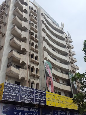
Health nearby صيدلية قريش الطبية 5
Saudi Arabia
Health nearby صيدلية قريش الطبية 5
صيدلية قريش الطبية 5
6704 An Nur, Mecca Saudi Arabia
contacts phone
:
+966
Latitude:
21.4445838
, Longitude:
39.8521194
read more
nearest Health
581 m
Aladl Red Crescent Center
6161, Mecca
Health
read more
600 m
مركز اسعاف العدل
6161, 3964, Mecca
Health
read more
617 m
مركز إسعاف جبل النور
Mecca
Health
read more
633 m
هيئة الهلال الاحمر السعودي-مركز اسعاف العدل ...Saudi Red Crescent Authority- Al Adel ambulance station
Al Hajj, Mecca
Health
read more
639 m
مركز إسعاف العدل رقم ( ٧ )
6113, Mecca
Health
read more
857 m
Laboratory Sayed Masoud Hassan Medical Analysis
2960 Al Khansa, Mecca
Health
read more
857 m
الدكتور ابو بكر العيدروس
2960 Al Khansa, 6254, Mecca
Health
read more
857 m
عيادات الدكتورة نجية السيد ( نساء و توليد )
2960 Al Khansa, Mecca
Health
read more
862 m
عيادة دكتورة نجية السيد
مكة
Health
read more
901 m
Makkah Taxi Travel And Tourism
Mecca
Health
read more
929 m
MAKKAHTAXITRAVELANDTOURISM
Mecca
Health
read more
994 m
عطار ملتقى البحرين
Al Khansa, Mecca
Health
read more
1.169 km
صيدلية خبراء الدواء
3353 طريق المسجد الحرام, 7997, Mecca
Health
read more
1.205 km
Bader Clinics
Mecca
Health
read more
1.346 km
Bawazeer glasses
Mecca
Health
read more
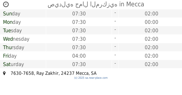
1.501 km
صيدليه جمال المركزيه
7630-7658 Ray Zakhir, Mecca
Health
read more
1.628 km
مركز إسعاف الشيشة
Mecca
Health
read more
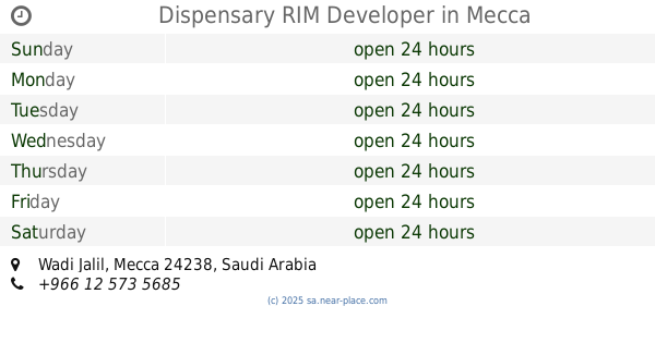
1.988 km
Dispensary RIM Developer
Mecca
Health
read more
2.507 km
Al Jaad Mahabas
3972, Mecca
Health
read more
2.527 km
مركز إسعاف الحجون
Al Masjid Al Haram Road, Mecca
Health
read more
2.528 km
مركز إسعاف الفلق
Al Masjid Al Haram Road, Mecca
Health
read more
2.53 km
مركز إسعاف منى 19
Mecca
Health
read more
2.611 km
مركز اسعاف العزيزية, مسجد الشيخ ابن باز, مکہ
Mecca
Health
read more
2.616 km
Srca Al Aziziyah Centre
8904 طريق المسجد الحرام, Mecca
Health
read more
2.638 km
دواء الحجاز الجزيرة
8558, Mecca
Health
read more
📑
all categories
Accounting
Administrative area level 1
Airport
Amusement park
Aquarium
Art gallery
Atm
Bakery
Bank
Bar
Beauty salon
Bicycle store
Book store
Bowling alley
Bus station
Cafe
Campground
Car dealer
Car rental
Car repair
Car wash
Casino
Cemetery
Church
City hall
Clothing store
Colloquial area
Convenience store
Country
Courthouse
Dentist
Department store
Doctor
Electrician
Electronics store
Embassy
Finance
Fire station
Florist
Food
Funeral home
Furniture store
Gas station
General contractor
Grocery or supermarket
Gym
Hair care
Hardware store
Health
Hindu Temple
Home goods store
Hospital
Insurance agency
Intersection
Jewelry store
Laundry
Lawyer
Library
Light rail station
Liquor store
Local government office
Locality
Locksmith
Lodging
Meal delivery
Meal takeaway
Mosque
Movie rental
Movie theater
Moving company
Museum
Natural feature
Neighborhood
Night club
Painter
Park
Parking
Pet store
Pharmacy
Physiotherapist
Place of worship
Plumber
Point of interest
Police
Political
Post office
Premise
Real estate agency
Restaurant
Roofing contractor
Route
Rv park, camping
School
Shoe store
Shopping mall
Spa
Stadium
Storage
Store
Sublocality
Subpremise
Subway station
Supermarket
Taxi stand
Train station
Transit station
Travel agency
University
Veterinary care
Zoo
sublocality level 1
↑