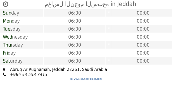
Laundry nearby مغاسل المجد السريعة
Coronavirus disease (COVID-19) Situation
confirmed cases
841469
deaths
9646
Saudi Arabia
Laundry nearby مغاسل المجد السريعة
مغاسل المجد السريعة
Jeddah Saudi Arabia
contacts phone
:
+966
Latitude:
21.5210791
, Longitude:
39.2619342
read more
nearest Laundry
41 m
مغاسل النخيل
Jeddah
Laundry
read more
260 m
المغاسل السويسرية
4565 King Abdullah Road, Jeddah
Laundry
read more
556 m
مغسلة ابو بدر
Jeddah
Laundry
read more
570 m
Abu Badr washbasins fast
Jeddah
Laundry
read more
676 m
دراي كلين
شارع الملك عبدالله، حي أبرق الرغامة، جدة
Laundry
read more
1.31 km
Solidarity sinks
حي النخيل،, Jeddah
Laundry
read more
1.461 km
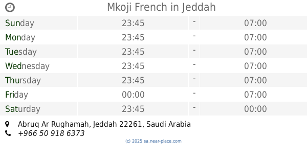
Mkoji French
Jeddah
Laundry
read more
1.462 km
مكوجي الفرنسية
شارع الرغام، حي قويزة، جدة
Laundry
read more
1.602 km
مغاسل الأطلال
أبرق الرغامه، الراية، جدة
Laundry
read more
1.69 km
مغاسل النجوم السبعه
Jeddah
Laundry
read more
1.716 km
مغاسل النجوم السبعه
شارع الرغامه_ حي قويزة، جدة
Laundry
read more
1.822 km
smart wash الغسلة الذكية
Jeddah
Laundry
read more
1.824 km
مغاسل الأرياف
حي ابرق الرغامة، جدة
Laundry
read more
1.853 km
مغاسل الرهدن
شارع الرغامة، حي قويزة، جدة
Laundry
read more
1.853 km
مغاسل الرهدن
شارع الرغام، حي قويزة، جدة
Laundry
read more
1.856 km
Rahdan Cleaners
حي ابرق الرغامة، 3015, Jeddah
Laundry
read more
1.89 km
مغاسل ال
3063, Abruq AR Rughamah District, Jeddah
Laundry
read more
1.921 km
مغاسل التاج السريعة
شارع محمد محمود زاهد، حي السليمانية، جدة
Laundry
read more
1.995 km
مغسلة حضر موت للملابس
Jeddah
Laundry
read more
2 km
مغاسل العائلة
شارع عمر السقاف، السليمانية، جدة
Laundry
read more
2.049 km
مغسلة السعودية
Jeddah
Laundry
read more
2.076 km
The time washbasins
Jeddah
Laundry
read more
2.119 km
مغسلة الراية للسيارات
جدة
Laundry
read more
2.123 km
Salman washbasins
Abdul Quddus Al Ansari, Jeddah
Laundry
read more
2.134 km
Rapid Shary washbasins
Abdul Quddus Al Ansari, Jeddah
Laundry
read more
📑
all categories
Accounting
Administrative area level 1
Airport
Amusement park
Aquarium
Art gallery
Atm
Bakery
Bank
Bar
Beauty salon
Bicycle store
Book store
Bowling alley
Bus station
Cafe
Campground
Car dealer
Car rental
Car repair
Car wash
Casino
Cemetery
Church
City hall
Clothing store
Colloquial area
Convenience store
Country
Courthouse
Dentist
Department store
Doctor
Electrician
Electronics store
Embassy
Finance
Fire station
Florist
Food
Funeral home
Furniture store
Gas station
General contractor
Grocery or supermarket
Gym
Hair care
Hardware store
Health
Hindu Temple
Home goods store
Hospital
Insurance agency
Intersection
Jewelry store
Laundry
Lawyer
Library
Light rail station
Liquor store
Local government office
Locality
Locksmith
Lodging
Meal delivery
Meal takeaway
Mosque
Movie rental
Movie theater
Moving company
Museum
Natural feature
Neighborhood
Night club
Painter
Park
Parking
Pet store
Pharmacy
Physiotherapist
Place of worship
Plumber
Point of interest
Police
Political
Post office
Premise
Real estate agency
Restaurant
Roofing contractor
Route
Rv park, camping
School
Shoe store
Shopping mall
Spa
Stadium
Storage
Store
Sublocality
Subpremise
Subway station
Supermarket
Taxi stand
Train station
Transit station
Travel agency
University
Veterinary care
Zoo
sublocality level 1
↑