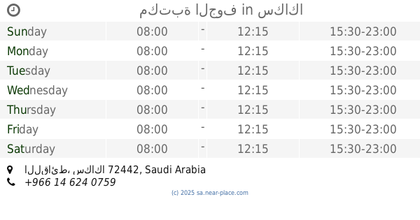
Library nearby مكتبة شمس
Saudi Arabia
Library nearby مكتبة شمس
مكتبة شمس
4355 طريق الملك خالد, Sakaka Saudi Arabia
contacts phone
:
+966
Latitude:
29.9934582
, Longitude:
40.2074212
read more
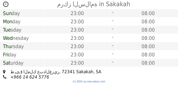
nearest Library
550 m
Public library
طريق الملك فهد بن عبدالعزيز, Sakaka
Library
read more
701 m
مكتبة النووي
سكاكا
Library
read more
1.974 km
مكتبة جرير
Sakaka
Library
read more
2.435 km
مكتبة البازعي
Al-Ma'aqlah
Library
read more
2.45 km
مكتبة البازعي
8848 طريق الملك عبدالعزيز, مخطط القديم, Sakaka
Library
read more
2.529 km
مكتبة الصديق
72341, Sakaka
Library
read more
2.529 km
Shamasi Library
3495 الملك فيصل, Sakaka
Library
read more
2.55 km
Saudi Center for Student Services
طريق الملك فيصل, Sakaka
Library
read more
3.013 km
مكتبة الجوف
سكاكا
Library
read more
3.066 km
مركز السلامة
طريق الملك عبدالعزيز, Sakaka
Library
read more
3.486 km
مكتبة رفاهية الانتظار
Sakaka
Library
read more
3.526 km
Fulfilling Library
سكاكا
Library
read more
3.962 km
Dar Al Uloom Al-Jouf Library
80, Sakaka
Library
read more
4.202 km
مكتبة المشعل
4089 طريق الملك عبدالعزيز, Sakaka
Library
read more
4.448 km
مكتبة مزايا الصديق
3061 King Fahd Ibn Abdulaziz Road, المحمدية ا, Sakaka
Library
read more
4.471 km
مكتبة المعرفة
2928 King Fahd Ibn Abdulaziz Road, المحمدية ا, Sakaka
Library
read more
4.512 km
Light Library
سكاكا
Library
read more
6.434 km
مكتبة الجوف
7007 King Fahd Ibn Abdulaziz Road, المحمدية و, Sakaka
Library
read more
6.802 km
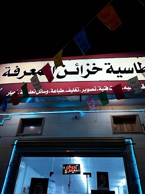
قرطاسية خزائن المعرفة
سكاكا
Library
read more
11.539 km
مكتبة ريناد الجوف
8448 King Khaled Road, Sakaka
Library
read more
13.161 km
Qara Library
King Khalid Road, مخطط الامل، سكاكا
Library
read more
26.934 km
المكتبة المركزية
Sakaka
Library
read more
26.934 km
مكتبة جامعة الجوف
Sakaka
Library
read more
26.942 km
المكتبة
Sakaka
Library
read more
132.234 km
Deanship of Library Affairs
Arar
Library
read more
📑
all categories
Accounting
Administrative area level 1
Airport
Amusement park
Aquarium
Art gallery
Atm
Bakery
Bank
Bar
Beauty salon
Bicycle store
Book store
Bowling alley
Bus station
Cafe
Campground
Car dealer
Car rental
Car repair
Car wash
Casino
Cemetery
Church
City hall
Clothing store
Colloquial area
Convenience store
Country
Courthouse
Dentist
Department store
Doctor
Electrician
Electronics store
Embassy
Finance
Fire station
Florist
Food
Funeral home
Furniture store
Gas station
General contractor
Grocery or supermarket
Gym
Hair care
Hardware store
Health
Hindu Temple
Home goods store
Hospital
Insurance agency
Intersection
Jewelry store
Laundry
Lawyer
Library
Light rail station
Liquor store
Local government office
Locality
Locksmith
Lodging
Meal delivery
Meal takeaway
Mosque
Movie rental
Movie theater
Moving company
Museum
Natural feature
Neighborhood
Night club
Painter
Park
Parking
Pet store
Pharmacy
Physiotherapist
Place of worship
Plumber
Point of interest
Police
Political
Post office
Premise
Real estate agency
Restaurant
Roofing contractor
Route
Rv park, camping
School
Shoe store
Shopping mall
Spa
Stadium
Storage
Store
Sublocality
Subpremise
Subway station
Supermarket
Taxi stand
Train station
Transit station
Travel agency
University
Veterinary care
Zoo
sublocality level 1
↑