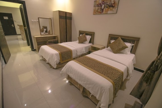
Lodging nearby اجنحة دارك المفروشة
Saudi Arabia
Lodging nearby اجنحة دارك المفروشة
اجنحة دارك المفروشة
4321, Nahawnd, 14515, Riyadh, SA Saudi Arabia
contacts phone
:
+966
Latitude:
24.5707665
, Longitude:
46.7697524
larger map & directions
read more
nearest Lodging
90 m
أجنحة دارك المفروشة
4286 Nahawnd, Riyadh
Lodging
read more
425 m
سكن العزيزية
العزيزية،, Riyadh
Lodging
read more
494 m
عمر بن عبدالله
Nahawnd, Riyadh
Lodging
read more
611 m
خالد بوطنه المنصب
نهاوند،، الرياض
Lodging
read more
704 m
VIP Hotel
Riyadh
Lodging
read more
829 m
Hala motel
7790 Mohammad Rashid Rida, Riyadh
Lodging
read more
893 m
إيليت للأجنحة الفندقية
العزيزية،, Riyadh
Lodging
read more
1.03 km
Ohaly HOME
2816 ابي دلامة، الدار البيضاء الرياض 14518 8474 Abi Dalamah, Riyadh
Lodging
read more
1.061 km
Palace Lawson Furnished Residential Units
Nahawnd, Riyadh
Lodging
read more
1.072 km
Qasr Wasan Furnished Unites Al Aziziyah
5317 Nahawnd Street, Riyadh
Lodging
read more
1.175 km
سكن عوائل بن طالب للعقار
3179 العزيزية، الرياض 14515
Lodging
read more
1.296 km
سكن شركة الدلتا السعوديه المحدوده
Wadi Hanifah, Riyadh
Lodging
read more
1.388 km
قصر الشيخ سليمان بن عبدالعزيز
عبدالقادر الجزائري،، الرياض
Lodging
read more
1.438 km
Albusaili villa
7666, 3262, Riyadh
Lodging
read more
1.586 km
Najmat Manami Azizyya
Abi Abdullah Alzawawi Street, Riyadh
Lodging
read more
1.706 km
كيان الجوهرة للعقارات
Mohammad Rashid Rida Mohammad Rashid Rida, Riyadh
Lodging
read more
1.733 km
Hala W Ghala2 Hotel
Al Rabat, Riyadh
Lodging
read more
1.74 km
Hla and spite 2
Riyadh
Lodging
read more
1.766 km
لؤلؤة العزيزيه
2627, Riyadh
Lodging
read more
1.768 km
Rahato hotel
3210-3228 Mohammad Rashid Rida, Riyadh
Lodging
read more
1.775 km
شقة ابو سعود
2555 وادي هجر، 7430, Riyadh
Lodging
read more
1.778 km
ملحق ال سعيّد
شارع شط القاعة،، الرياض
Lodging
read more
1.782 km
زهرة لمار
Shabab, Riyadh
Lodging
read more
1.786 km
قصر الليل للشقق المفروشة
2153 طريق فتح مكة, Riyadh
Lodging
read more
1.786 km
قصر الليل
2153 طريق فتح مكة، الرياض
Lodging
read more
📑
all categories
Accounting
Administrative area level 1
Airport
Amusement park
Aquarium
Art gallery
Atm
Bakery
Bank
Bar
Beauty salon
Bicycle store
Book store
Bowling alley
Bus station
Cafe
Campground
Car dealer
Car rental
Car repair
Car wash
Casino
Cemetery
Church
City hall
Clothing store
Colloquial area
Convenience store
Country
Courthouse
Dentist
Department store
Doctor
Electrician
Electronics store
Embassy
Finance
Fire station
Florist
Food
Funeral home
Furniture store
Gas station
General contractor
Grocery or supermarket
Gym
Hair care
Hardware store
Health
Hindu Temple
Home goods store
Hospital
Insurance agency
Intersection
Jewelry store
Laundry
Lawyer
Library
Light rail station
Liquor store
Local government office
Locality
Locksmith
Lodging
Meal delivery
Meal takeaway
Mosque
Movie rental
Movie theater
Moving company
Museum
Natural feature
Neighborhood
Night club
Painter
Park
Parking
Pet store
Pharmacy
Physiotherapist
Place of worship
Plumber
Point of interest
Police
Political
Post office
Premise
Real estate agency
Restaurant
Roofing contractor
Route
Rv park, camping
School
Shoe store
Shopping mall
Spa
Stadium
Storage
Store
Sublocality
Subpremise
Subway station
Supermarket
Taxi stand
Train station
Transit station
Travel agency
University
Veterinary care
Zoo
sublocality level 1
↑