Lodging nearby Al Sharqi Hotel 1
Saudi Arabia
Lodging nearby Al Sharqi Hotel 1
Al Sharqi Hotel 1
Prince Saud bin Abdul Mohsen Al-Saud Street, An Nuqrah District.، An Nuqrah, Hail 55422, Saudi Arabia
contacts phone
:
+966 59 533 6549
Latitude:
27.4636139
, Longitude:
41.6445927
larger map & directions
read more
nearest Lodging
10 m
كيان حائل
Hail
Lodging
read more
16 m
East hotel
شارع الأمير سعود بن عبدالمحسن آل سعود, Hail
Lodging
read more
130 m
سكون للأجنحة الفندقية
شارع الأمير سعود بن عبدالمحسن آل سعود, Hail
Lodging
read more
225 m
Virginia Resort
شارع الأمير سعود بن عبدالمحسن آل سعود, Hail
Lodging
read more
237 m
May Rest
شارع الأمير سعود بن عبدالمحسن آل سعود, Hail
Lodging
read more
244 m
منتجع سحابة النسائي العائلي
3360, 6962, Hail
Lodging
read more
296 m
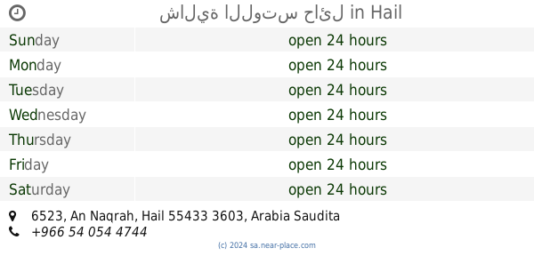
شالية اللوتس حائل
6523, Hail
Lodging
read more
406 m
منتجع ماريز
3927 النقرة، حائل 55433
Lodging
read more
496 m
منتجع المربع الذهبي
Al Qaid
Lodging
read more
522 m
DARR MESK Hotel
حائل _ حي الشفاء _ شرق مستوصف الساهر, Hail
Lodging
read more
546 m
Dar Boushima Furnished Residential Units
شارع الأمير سعود بن عبدالمحسن آل سعود, Hail
Lodging
read more
549 m
دار شيمة للوحدات السكنية
6539, Hail
Lodging
read more
563 m
Asalhani Recruitment
3876, Hail
Lodging
read more
653 m
شاليهات دريم - Dream Chalets
8728, 4816, Hail
Lodging
read more
706 m
أستراحة البندقية
4723, Hail
Lodging
read more
800 m
Corsica Resort
Hail
Lodging
read more
894 m
شاليهات جي ايس - G ice
Hail
Lodging
read more
1.044 km
استراحة ريحانة
Hail
Lodging
read more
1.142 km
استراحة نورين
King Saud Road, Hail
Lodging
read more
1.166 km
منتجع وارفه
حائل
Lodging
read more
1.183 km
Rose Hail Break
4318, Hail
Lodging
read more
1.193 km
شاليه كيوت
Hail
Lodging
read more
1.224 km
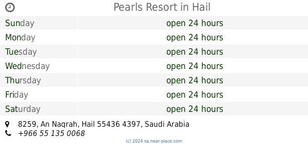
Pearls Resort
8259, Hail
Lodging
read more
1.242 km
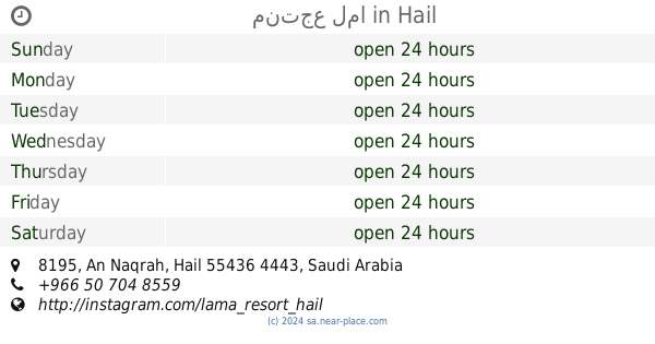
منتجع لما
8195, Hail
Lodging
read more
1.312 km
Apartments Mountain Palace
3009 طريق الملك سعود, Hail
Lodging
read more
📑
all categories
Accounting
Administrative area level 1
Airport
Amusement park
Aquarium
Art gallery
Atm
Bakery
Bank
Bar
Beauty salon
Bicycle store
Book store
Bowling alley
Bus station
Cafe
Campground
Car dealer
Car rental
Car repair
Car wash
Casino
Cemetery
Church
City hall
Clothing store
Colloquial area
Convenience store
Country
Courthouse
Dentist
Department store
Doctor
Electrician
Electronics store
Embassy
Finance
Fire station
Florist
Food
Funeral home
Furniture store
Gas station
General contractor
Grocery or supermarket
Gym
Hair care
Hardware store
Health
Hindu Temple
Home goods store
Hospital
Insurance agency
Intersection
Jewelry store
Laundry
Lawyer
Library
Light rail station
Liquor store
Local government office
Locality
Locksmith
Lodging
Meal delivery
Meal takeaway
Mosque
Movie rental
Movie theater
Moving company
Museum
Natural feature
Neighborhood
Night club
Painter
Park
Parking
Pet store
Pharmacy
Physiotherapist
Place of worship
Plumber
Point of interest
Police
Political
Post office
Premise
Real estate agency
Restaurant
Roofing contractor
Route
Rv park, camping
School
Shoe store
Shopping mall
Spa
Stadium
Storage
Store
Sublocality
Subpremise
Subway station
Supermarket
Taxi stand
Train station
Transit station
Travel agency
University
Veterinary care
Zoo
sublocality level 1
↑