Lodging nearby اسكان مطار الملك خالد
Saudi Arabia
Lodging nearby اسكان مطار الملك خالد
اسكان مطار الملك خالد
Riyadh Saudi Arabia
contacts phone
:
+966
Latitude:
24.944327
, Longitude:
46.676383
read more
nearest Lodging
2.729 km
Tav Riyadh 4 Yıldız Hotel
Riyadh
Lodging
read more
2.791 km
Saudia Airlines Catering Accomodation
Unnamed Road, Riyadh
Lodging
read more
3.228 km
غرفة انتظار للسيدات
مطار الملك خالد الدولي،, Riyadh
Lodging
read more
3.668 km
AlGussi Airlines Accomodation
Riyadh
Lodging
read more
4.29 km
Makarem Riyadh Airport Hotel
Near King Khalid International Airport, Airport Road، الرياض
Lodging
read more
4.745 km
Riyadh Airport Marriott Hotel
Abdullah Alsahmi Street, Al Safarat Near King Khaled International Airport, Riyadh
Lodging
read more
5.497 km
شاليهات الباتشولي
Unnamed Road, Riyadh
Lodging
read more
5.719 km
شاليهات لومان
Riyadh
Lodging
read more
5.738 km
QMNDA Resort
Riyadh
Lodging
read more
5.993 km
شاليهات رفاه
Riyadh
Lodging
read more
6.098 km
استراحة ريف النرجس
Abi Bakr As Siddiq Rd, An Narjis، الرياض
Lodging
read more
6.258 km
شاليهات المركاز
Riyadh
Lodging
read more
6.393 km
شاليهات القمرا
Riyadh
Lodging
read more
6.455 km
Chalets park singing
Riyadh
Lodging
read more
6.486 km
شاليهات لافلور
Riyadh
Lodging
read more
6.911 km
Chalets Moon Light
شارع ريحانه بنت يزيد، الرياض
Lodging
read more
6.929 km
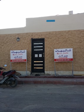
Joey Castle
Rihana Bint Zaid Street, Riyadh
Lodging
read more
7.44 km
شاليه هلا
Unnamed Road, Riyadh
Lodging
read more
7.497 km
Chalet Rimda
Riyadh
Lodging
read more
7.752 km
شاليهات أرياف
Unnamed Road, Riyadh
Lodging
read more
7.838 km
Shapoorji Pallonji Seco Accomodation
Riyadh
Lodging
read more
7.874 km
Daffodils as 7 Resort
Uthman Ibn Affan Road, Riyadh
Lodging
read more
7.886 km
شاليهات جولدن ساندز
Khuzam Road, Riyadh
Lodging
read more
8.126 km
Chalets de Hafland
Unnamed Road, Riyadh
Lodging
read more
8.138 km
View Chalets
Riyadh
Lodging
read more
📑
all categories
Accounting
Administrative area level 1
Airport
Amusement park
Aquarium
Art gallery
Atm
Bakery
Bank
Bar
Beauty salon
Bicycle store
Book store
Bowling alley
Bus station
Cafe
Campground
Car dealer
Car rental
Car repair
Car wash
Casino
Cemetery
Church
City hall
Clothing store
Colloquial area
Convenience store
Country
Courthouse
Dentist
Department store
Doctor
Electrician
Electronics store
Embassy
Finance
Fire station
Florist
Food
Funeral home
Furniture store
Gas station
General contractor
Grocery or supermarket
Gym
Hair care
Hardware store
Health
Hindu Temple
Home goods store
Hospital
Insurance agency
Intersection
Jewelry store
Laundry
Lawyer
Library
Light rail station
Liquor store
Local government office
Locality
Locksmith
Lodging
Meal delivery
Meal takeaway
Mosque
Movie rental
Movie theater
Moving company
Museum
Natural feature
Neighborhood
Night club
Painter
Park
Parking
Pet store
Pharmacy
Physiotherapist
Place of worship
Plumber
Point of interest
Police
Political
Post office
Premise
Real estate agency
Restaurant
Roofing contractor
Route
Rv park, camping
School
Shoe store
Shopping mall
Spa
Stadium
Storage
Store
Sublocality
Subpremise
Subway station
Supermarket
Taxi stand
Train station
Transit station
Travel agency
University
Veterinary care
Zoo
sublocality level 1
↑