Lodging nearby استراحة القمه للإيجار
Saudi Arabia
Lodging nearby استراحة القمه للإيجار
استراحة القمه للإيجار
جدة Saudi Arabia
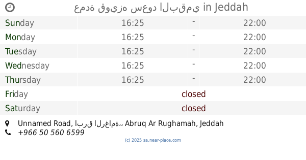
contacts phone
:
+966
Latitude:
21.5307625
, Longitude:
39.314413
read more
nearest Lodging
43 m
استراحة alsa7ab_jed
Jeddah
Lodging
read more
859 m
إستراحة الضيعه
Jeddah
Lodging
read more
911 m
استراحة درة الجوهرة
Falastin, امتداد, شرقاً
Lodging
read more
1.152 km
وادي مريخ
Unnamed Road, Jeddah
Lodging
read more
1.383 km
Msult Bin Abdullah Al-Jassar
رقم المبنى 2392 الرمز البريدي الرقم الإضافي 6608, Jeddah
Lodging
read more
1.567 km
عمارة يوسف العبادي
Jeddah
Lodging
read more
2.557 km
استراحة راقية الداموك
Unnamed Road،, Jeddah
Lodging
read more
2.579 km
استراحة راقية جدة
Unnamed Road، Jeddah 23262, Jeddah
Lodging
read more
2.743 km
إستراحة جنة
Jeddah
Lodging
read more
2.75 km
استراحة الشنب الكناني
r, Jeddah
Lodging
read more
2.802 km
استراحة نصف القمر
Jeddah
Lodging
read more
2.818 km
القمة ريزدنس
جدة
Lodging
read more
2.881 km
استراحة العطاء الخاصة
Jeddah
Lodging
read more
2.911 km
استراحة المهند
Unnamed Road, Jeddah
Lodging
read more
2.962 km
عمارة التيسير
Jeddah
Lodging
read more
2.986 km
استراحة الفرسان
جدة السعودية حي مريّخ قريب من, مسجد الرحمه, Jeddah
Lodging
read more
3.115 km
Shangri-la Avenue Accomodation
Wadi Marikh, Jeddah
Lodging
read more
3.294 km
إستراحة جوهرة التيسير
21, .555791,39.297374
Lodging
read more
3.307 km
استراحة دار السحاب
Jeddah
Lodging
read more
3.313 km
إستراحة دارا السحاب
Jeddah
Lodging
read more
3.372 km
استراحات النخبة للشباب
Jeddah
Lodging
read more
3.562 km
استراحة التراثيه
Jeddah
Lodging
read more
3.566 km
عمدة قويزه سعود البقمي
Unnamed Road, ابرق الرغامة،, Jeddah
Lodging
read more
3.632 km
شقة أم ماجد
Jeddah
Lodging
read more
3.636 km
استراحة نور
Unnamed Road, Jeddah
Lodging
read more
📑
all categories
Accounting
Administrative area level 1
Airport
Amusement park
Aquarium
Art gallery
Atm
Bakery
Bank
Bar
Beauty salon
Bicycle store
Book store
Bowling alley
Bus station
Cafe
Campground
Car dealer
Car rental
Car repair
Car wash
Casino
Cemetery
Church
City hall
Clothing store
Colloquial area
Convenience store
Country
Courthouse
Dentist
Department store
Doctor
Electrician
Electronics store
Embassy
Finance
Fire station
Florist
Food
Funeral home
Furniture store
Gas station
General contractor
Grocery or supermarket
Gym
Hair care
Hardware store
Health
Hindu Temple
Home goods store
Hospital
Insurance agency
Intersection
Jewelry store
Laundry
Lawyer
Library
Light rail station
Liquor store
Local government office
Locality
Locksmith
Lodging
Meal delivery
Meal takeaway
Mosque
Movie rental
Movie theater
Moving company
Museum
Natural feature
Neighborhood
Night club
Painter
Park
Parking
Pet store
Pharmacy
Physiotherapist
Place of worship
Plumber
Point of interest
Police
Political
Post office
Premise
Real estate agency
Restaurant
Roofing contractor
Route
Rv park, camping
School
Shoe store
Shopping mall
Spa
Stadium
Storage
Store
Sublocality
Subpremise
Subway station
Supermarket
Taxi stand
Train station
Transit station
Travel agency
University
Veterinary care
Zoo
sublocality level 1
↑