Lodging nearby استراحة الشيخ عبدالله محمد الطريقي
Saudi Arabia
Lodging nearby استراحة الشيخ عبدالله محمد الطريقي
استراحة الشيخ عبدالله محمد الطريقي
Buraydah 52369, Saudi Arabia
contacts phone
:
+966
Latitude:
26.3714861
, Longitude:
44.0369374
larger map & directions
read more
nearest Lodging
325 m
عبدالكريم ابوحمود
Buraydah
Lodging
read more
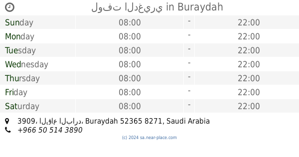
557 m
لوفت الدغيري
3909, Buraydah
Lodging
read more
903 m
شاليه ديفانو للاجار اليومي
7811, Buraydah
Lodging
read more
999 m
شاليه ياسر الرشودي
بريدة
Lodging
read more
1.006 km
منتجع نثال الرمال
Buraydah
Lodging
read more
1.081 km
Chalet for Crown
7788, Buraydah
Lodging
read more
1.095 km
شاليهات المدهال
3609, 7749, Buraydah
Lodging
read more
1.1 km
استراحة صلة
At Taghirah, Buraydah
Lodging
read more
1.104 km
Chalet Sand
3609, Buraydah
Lodging
read more
1.145 km
شالية إيڤا chalet Eva
بريدة
Lodging
read more
1.145 km
شالية إيفا
بريدة
Lodging
read more
1.146 km
chalet eva
بريدة
Lodging
read more
1.149 km
ديوانية الشمري التراثية
Eastern Ring Rd, Buraydah
Lodging
read more
1.186 km
شاليه جيفارا رويال
Buraydah
Lodging
read more
1.19 km
Chalet stars
3685, Buraydah
Lodging
read more
1.198 km
شاليه جوري
Buraydah
Lodging
read more
1.229 km
شاليه الألفه
6797, Buraydah
Lodging
read more
1.263 km
Chalets Palm
6819, Buraydah
Lodging
read more
1.297 km
شالية السمو
7433, Buraydah
Lodging
read more
1.324 km
Marina Reserve and Chalet
6781, Buraydah
Lodging
read more
1.378 km
Chalet beautiful evening
3397, Buraydah
Lodging
read more
1.384 km
شاليه اجمل امسية
Buraydah
Lodging
read more
1.401 km
شالية أبو ياسر
6943, 3361, Buraydah
Lodging
read more
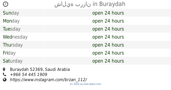
1.404 km
شالية برزان
Buraydah
Lodging
read more
1.417 km
Chalets Hjan
3383, Buraydah
Lodging
read more
📑
all categories
Accounting
Administrative area level 1
Airport
Amusement park
Aquarium
Art gallery
Atm
Bakery
Bank
Bar
Beauty salon
Bicycle store
Book store
Bowling alley
Bus station
Cafe
Campground
Car dealer
Car rental
Car repair
Car wash
Casino
Cemetery
Church
City hall
Clothing store
Colloquial area
Convenience store
Country
Courthouse
Dentist
Department store
Doctor
Electrician
Electronics store
Embassy
Finance
Fire station
Florist
Food
Funeral home
Furniture store
Gas station
General contractor
Grocery or supermarket
Gym
Hair care
Hardware store
Health
Hindu Temple
Home goods store
Hospital
Insurance agency
Intersection
Jewelry store
Laundry
Lawyer
Library
Light rail station
Liquor store
Local government office
Locality
Locksmith
Lodging
Meal delivery
Meal takeaway
Mosque
Movie rental
Movie theater
Moving company
Museum
Natural feature
Neighborhood
Night club
Painter
Park
Parking
Pet store
Pharmacy
Physiotherapist
Place of worship
Plumber
Point of interest
Police
Political
Post office
Premise
Real estate agency
Restaurant
Roofing contractor
Route
Rv park, camping
School
Shoe store
Shopping mall
Spa
Stadium
Storage
Store
Sublocality
Subpremise
Subway station
Supermarket
Taxi stand
Train station
Transit station
Travel agency
University
Veterinary care
Zoo
sublocality level 1
↑