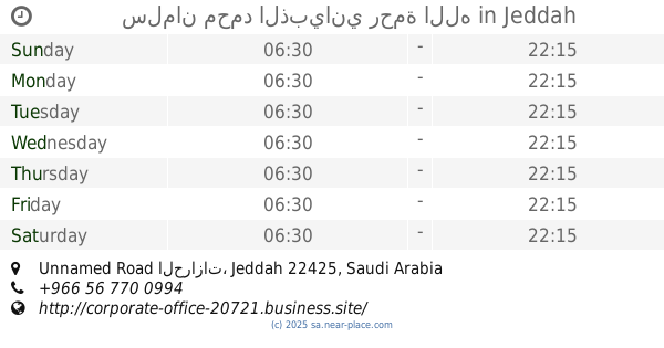
Lodging nearby Break Mohammed bin aggressive Hebrew
Saudi Arabia
Lodging nearby Break Mohammed bin aggressive Hebrew
Break Mohammed bin aggressive Hebrew
طريق الحرازات, 22391, Jeddah, SA Saudi Arabia
contacts phone
:
+966
Latitude:
21.4859273
, Longitude:
39.3490523
larger map & directions
read more
nearest Lodging
133 m
سلمان محمد الذبياني رحمة الله
Unnamed Road الحرازات, Jeddah
Lodging
read more
413 m
ود للإحتفالات والمناسبات ( الشيخ / احمد الشغاغه).
Jeddah
Lodging
read more
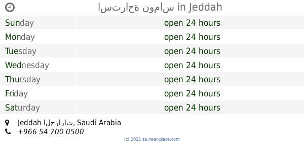
446 m
الاستراحة المائية
Jeddah
Lodging
read more
487 m
Harazath M i liton
Jeddah
Lodging
read more
493 m
استراحة نوماس
Jeddah
Lodging
read more
558 m
Alfaneyah Duct Factory
Industrial Area, Phase 4, Street no.404, Jeddah
Lodging
read more
729 m
استراحة الورود
Al Harajat، جدة
Lodging
read more
1.185 km
استراحه الجوري للمناسبات
Jeddah
Lodging
read more
1.186 km
Waqf Furnished Apartments
Jeddah
Lodging
read more
1.231 km
استراحه المنار للحتفالات
Jeddah
Lodging
read more
1.364 km
شالية 5ستار (العائلي)
Jeddah
Lodging
read more
1.372 km
شالية نورعيوني للراحة العائلية تحت الانشاء
Jeddah
Lodging
read more
1.406 km
Whispered clouds occasions
Jeddah
Lodging
read more
1.472 km
استراحة تارا
شارع، الحرازات، مرحبا
Lodging
read more
1.563 km
استراحة وقاعة الروشان
Fatimah Market Street, Al Harazaath، جدة
Lodging
read more
1.563 km
استراحة الروشان
Fatimah Market Street, Al Harazaath، جدة
Lodging
read more
1.564 km
Estrahat AlMalki
Jeddah
Lodging
read more
1.61 km
استراحة جنان
Jeddah
Lodging
read more
1.685 km
استراحة نسائم الجنوب للمناسبات
Jeddah
Lodging
read more
1.693 km
استراحة قراند لاند
Jeddah
Lodging
read more
1.784 km
استراحة نجمة الليل
Jeddah
Lodging
read more
1.798 km
شاليهات الخير الراقية
Jeddah
Lodging
read more
1.858 km
Family Break
Jeddah
Lodging
read more
1.925 km
قاعة البدر الحرازات
Unnamed Road, Jeddah
Lodging
read more
2.025 km
Break Al Rayyan
Jeddah
Lodging
read more
📑
all categories
Accounting
Administrative area level 1
Airport
Amusement park
Aquarium
Art gallery
Atm
Bakery
Bank
Bar
Beauty salon
Bicycle store
Book store
Bowling alley
Bus station
Cafe
Campground
Car dealer
Car rental
Car repair
Car wash
Casino
Cemetery
Church
City hall
Clothing store
Colloquial area
Convenience store
Country
Courthouse
Dentist
Department store
Doctor
Electrician
Electronics store
Embassy
Finance
Fire station
Florist
Food
Funeral home
Furniture store
Gas station
General contractor
Grocery or supermarket
Gym
Hair care
Hardware store
Health
Hindu Temple
Home goods store
Hospital
Insurance agency
Intersection
Jewelry store
Laundry
Lawyer
Library
Light rail station
Liquor store
Local government office
Locality
Locksmith
Lodging
Meal delivery
Meal takeaway
Mosque
Movie rental
Movie theater
Moving company
Museum
Natural feature
Neighborhood
Night club
Painter
Park
Parking
Pet store
Pharmacy
Physiotherapist
Place of worship
Plumber
Point of interest
Police
Political
Post office
Premise
Real estate agency
Restaurant
Roofing contractor
Route
Rv park, camping
School
Shoe store
Shopping mall
Spa
Stadium
Storage
Store
Sublocality
Subpremise
Subway station
Supermarket
Taxi stand
Train station
Transit station
Travel agency
University
Veterinary care
Zoo
sublocality level 1
↑