Lodging nearby Chalets Bandos
Saudi Arabia
Lodging nearby Chalets Bandos
Chalets Bandos
4184, Ar Rihab, Buraydah 52581 8614, Saudi Arabia
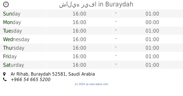
contacts phone
:
+966 56 700 6777
Latitude:
26.4116677
, Longitude:
43.8975893
larger map & directions
read more
nearest Lodging
51 m
Al Jazeera residential units
4184, Buraydah
Lodging
read more
164 m
Al Jazeera residential units sINGleS
4071, Buraydah
Lodging
read more
216 m
شاليه كلاود Cloud
الرحاب، القصيم ، بريدة ، شمال بريدة ، قرب مخطط قرطبة، والرحاب،, Buraydah
Lodging
read more
463 m
شقق عزاب المسكن الهادئ
Buraydah
Lodging
read more
487 m
ضيافة المخلف بقرطبة
4706, 8517, Buraydah
Lodging
read more
491 m
شالية ريبان
3732, Buraydah
Lodging
read more
592 m
استراحة خالد العمر
8176، الرحاب، بريدة 52581
Lodging
read more
608 m
شقق الدرة
Unnamed Road, Buraydah
Lodging
read more
615 m
استراحة الدرر
8014, Buraydah
Lodging
read more
733 m
Island Park
بريدة حي الرحاب الدائري الشمالي, Buraydah
Lodging
read more
866 m
Break Tobi
Northern Ring Road, Buraydah
Lodging
read more
963 m
مجمع سواعد
7714, Buraydah
Lodging
read more
991 m
شقق عزاب فاخرة
Buraydah
Lodging
read more
1.037 km
Fife Chalets
3495, Buraydah
Lodging
read more
1.092 km
Al Ertiqa for Hotel Suites 4 (Al Qassim)
Buraydah
Lodging
read more
1.189 km
Chalet Lunar
3841, Buraydah
Lodging
read more
1.312 km
Chalets Flamengo
شارع قرطبة, Buraydah
Lodging
read more
1.324 km
Ezdan Al Qassim Aparthotel
شارع قرطبة، Ar Rafī‘ah
Lodging
read more
1.344 km
EZDAN ELQASSIM
Buraydah
Lodging
read more
1.504 km
استراحة الفنار
Buraydah
Lodging
read more
1.546 km
Palm Chalet
شارع البخاري, Buraydah
Lodging
read more
1.583 km
شاليه ريفا
Buraydah
Lodging
read more
1.6 km
شقق الطالب
Buraydah
Lodging
read more
1.633 km
Clinic Resort
3298, Buraydah
Lodging
read more
1.634 km
شاليه جنتي بريدة
القصيم بريدة حي الريان غرب معهد النور, Buraydah
Lodging
read more
📑
all categories
Accounting
Administrative area level 1
Airport
Amusement park
Aquarium
Art gallery
Atm
Bakery
Bank
Bar
Beauty salon
Bicycle store
Book store
Bowling alley
Bus station
Cafe
Campground
Car dealer
Car rental
Car repair
Car wash
Casino
Cemetery
Church
City hall
Clothing store
Colloquial area
Convenience store
Country
Courthouse
Dentist
Department store
Doctor
Electrician
Electronics store
Embassy
Finance
Fire station
Florist
Food
Funeral home
Furniture store
Gas station
General contractor
Grocery or supermarket
Gym
Hair care
Hardware store
Health
Hindu Temple
Home goods store
Hospital
Insurance agency
Intersection
Jewelry store
Laundry
Lawyer
Library
Light rail station
Liquor store
Local government office
Locality
Locksmith
Lodging
Meal delivery
Meal takeaway
Mosque
Movie rental
Movie theater
Moving company
Museum
Natural feature
Neighborhood
Night club
Painter
Park
Parking
Pet store
Pharmacy
Physiotherapist
Place of worship
Plumber
Point of interest
Police
Political
Post office
Premise
Real estate agency
Restaurant
Roofing contractor
Route
Rv park, camping
School
Shoe store
Shopping mall
Spa
Stadium
Storage
Store
Sublocality
Subpremise
Subway station
Supermarket
Taxi stand
Train station
Transit station
Travel agency
University
Veterinary care
Zoo
sublocality level 1
↑