Lodging nearby Diar al-Tai Furnished Apartments
Saudi Arabia
Lodging nearby Diar al-Tai Furnished Apartments
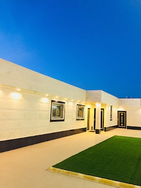
Diar al-Tai Furnished Apartments
4472، السويفلة، حائل 55481 6281, Saudi Arabia
contacts phone
:
+966
Latitude:
27.5576778
, Longitude:
41.726433
larger map & directions
read more
nearest Lodging
159 m
Jaw Hail
Hail
Lodging
read more
243 m
دانية النخيل شقق مفروشة
حائل
Lodging
read more
262 m
شقق دانة النخيل
Unnamed Road, Hail
Lodging
read more
302 m
وردة تولينا للوحدات السكنية
4054 طريق الامير عبدالله بن عبدالعزيز, Hail
Lodging
read more
358 m
Revan housing units
3912 طريق الامير عبدالله بن عبدالعزيز, Hail
Lodging
read more
417 m
Hmaal residential units
3847 طريق الامير عبدالله بن عبدالعزيز, Hail
Lodging
read more
417 m
Hmaal Suites Hotel Lhqq
طريق الامير عبدالله بن عبدالعزيز، الزهراء، حائل
Lodging
read more
443 m
Hail breezes
King Abdullah Road, Hail
Lodging
read more
509 m
Al Remal Hotel Suites Hail
شارع الملك فهد، المنتزه الشرقي، هيل
Lodging
read more
814 m
شاليهات نوادر
Unnamed Road, Hail
Lodging
read more
1.081 km
بيت سند سلمان ال خمسام
Hail
Lodging
read more
1.136 km
Wahg Alkhalidiya
الدائري الشرقي, حي المملكة, Hail
Lodging
read more
1.344 km
تميز الاقامة
الخزامي، حائل
Lodging
read more
1.454 km
Kingdom Resort
3568, Hail
Lodging
read more
1.636 km
استراحة الأضواء
حائل
Lodging
read more
1.768 km
منتجع الذهبية للاحتفالات شاليه استراحة
Unnamed Road, Hail
Lodging
read more
1.889 km
Lamia Resort and juicy Kingdom
4207, Hail
Lodging
read more
1.9 km
زهرة البلاد للشقق المفروشة
3251، المنتزه الشرقي، حائل 55428
Lodging
read more
1.963 km
استراحة الرين
4334 حائل 55429
Lodging
read more
1.974 km
منتجع بيروت للايجار اليومي
3550, 8140, Hail
Lodging
read more
1.999 km
قصر الخزامى للشقق المفروشه
7285, Hail
Lodging
read more
2.017 km
منتجع ويك إند
Saudi Arabia
Lodging
read more
2.017 km
منتجع ويك إند
Lodging
read more
2.035 km
Turan hotel
Hail
Lodging
read more
2.046 km
استراحة الضياغم
السويفلة،، حائل
Lodging
read more
📑
all categories
Accounting
Administrative area level 1
Airport
Amusement park
Aquarium
Art gallery
Atm
Bakery
Bank
Bar
Beauty salon
Bicycle store
Book store
Bowling alley
Bus station
Cafe
Campground
Car dealer
Car rental
Car repair
Car wash
Casino
Cemetery
Church
City hall
Clothing store
Colloquial area
Convenience store
Country
Courthouse
Dentist
Department store
Doctor
Electrician
Electronics store
Embassy
Finance
Fire station
Florist
Food
Funeral home
Furniture store
Gas station
General contractor
Grocery or supermarket
Gym
Hair care
Hardware store
Health
Hindu Temple
Home goods store
Hospital
Insurance agency
Intersection
Jewelry store
Laundry
Lawyer
Library
Light rail station
Liquor store
Local government office
Locality
Locksmith
Lodging
Meal delivery
Meal takeaway
Mosque
Movie rental
Movie theater
Moving company
Museum
Natural feature
Neighborhood
Night club
Painter
Park
Parking
Pet store
Pharmacy
Physiotherapist
Place of worship
Plumber
Point of interest
Police
Political
Post office
Premise
Real estate agency
Restaurant
Roofing contractor
Route
Rv park, camping
School
Shoe store
Shopping mall
Spa
Stadium
Storage
Store
Sublocality
Subpremise
Subway station
Supermarket
Taxi stand
Train station
Transit station
Travel agency
University
Veterinary care
Zoo
sublocality level 1
↑