Lodging nearby Family day شالية يوم العائلة
Saudi Arabia
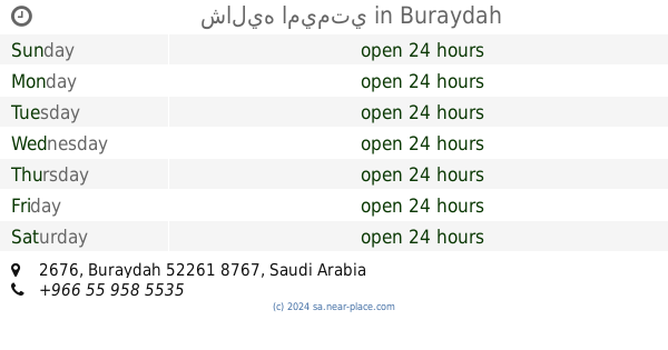
Lodging nearby Family day شالية يوم العائلة
Family day شالية يوم العائلة
Buraydah Saudi Arabia
contacts phone
:
+966
Latitude:
26.4389575
, Longitude:
43.9112967
read more
nearest Lodging
90 m
Nuralia Rest House
2795, 8753, Buraydah
Lodging
read more
91 m
استراحة المشاعل
8713, Buraydah
Lodging
read more
144 m
شاليهات نوراليا
Buraydah
Lodging
read more
144 m
استراحة بانوراما
2862 بريدة 52261
Lodging
read more
194 m
Chalet bronze Rose
شاليه برونز روز, Buraydah
Lodging
read more
199 m
Lavender لاڤندر
8677, Buraydah
Lodging
read more
200 m
Break generosity
Buraydah
Lodging
read more
216 m
شالية هيفين
Buraydah
Lodging
read more
219 m
شاليه اميمتي
2676, Buraydah
Lodging
read more
220 m
شاليه فانسي
Unnamed Road, Buraydah
Lodging
read more
224 m
Chalet Mrbala
Umar Ibn Al Khatab Road, Buraydah
Lodging
read more
225 m
شاليه تالينوف
8956, 2810, Buraydah
Lodging
read more
229 m
شاليه لاند
Umar Ibn Al Khatab Road, Buraydah
Lodging
read more
250 m
شاليهات روعه
Buraydah
Lodging
read more
258 m
Alwadi Resort
2634, Buraydah
Lodging
read more
264 m
Rose Break
9015, 2863, Buraydah
Lodging
read more
266 m
روز للمناسبات
طريق عمر بن الخطاب، حي الراشديات، بريدة
Lodging
read more
267 m
شاليه هولستن
طريق عمر بن الخطاب، حي الراشديات، بريدة
Lodging
read more
296 m
استراحة بهيجة
Buraydah
Lodging
read more
299 m
استراحة الياسرية
طريق عمر بن الخطاب، حي الراشديات، بريدة
Lodging
read more
347 m
استراحة المكحل
Buraydah
Lodging
read more
353 m
استراحة الشيخ محمد بن علي ابراهيم البليهد
Unnamed Road, Buraydah
Lodging
read more
373 m
شاليه فوز
Buraydah
Lodging
read more
379 m
Chalet undershirt
3180, 9067, Buraydah
Lodging
read more
381 m
Happy Night
شارع عمر بن الخطاب، الراشديات، بريدة
Lodging
read more
📑
all categories
Accounting
Administrative area level 1
Airport
Amusement park
Aquarium
Art gallery
Atm
Bakery
Bank
Bar
Beauty salon
Bicycle store
Book store
Bowling alley
Bus station
Cafe
Campground
Car dealer
Car rental
Car repair
Car wash
Casino
Cemetery
Church
City hall
Clothing store
Colloquial area
Convenience store
Country
Courthouse
Dentist
Department store
Doctor
Electrician
Electronics store
Embassy
Finance
Fire station
Florist
Food
Funeral home
Furniture store
Gas station
General contractor
Grocery or supermarket
Gym
Hair care
Hardware store
Health
Hindu Temple
Home goods store
Hospital
Insurance agency
Intersection
Jewelry store
Laundry
Lawyer
Library
Light rail station
Liquor store
Local government office
Locality
Locksmith
Lodging
Meal delivery
Meal takeaway
Mosque
Movie rental
Movie theater
Moving company
Museum
Natural feature
Neighborhood
Night club
Painter
Park
Parking
Pet store
Pharmacy
Physiotherapist
Place of worship
Plumber
Point of interest
Police
Political
Post office
Premise
Real estate agency
Restaurant
Roofing contractor
Route
Rv park, camping
School
Shoe store
Shopping mall
Spa
Stadium
Storage
Store
Sublocality
Subpremise
Subway station
Supermarket
Taxi stand
Train station
Transit station
Travel agency
University
Veterinary care
Zoo
sublocality level 1
↑