Lodging nearby فندق الصفوة
Saudi Arabia
Lodging nearby فندق الصفوة
فندق الصفوة
Al Ful, Mecca Saudi Arabia
contacts phone
:
+966
Latitude:
21.4143338
, Longitude:
39.8657199
read more
nearest Lodging
30 m
فندق وزان wazan Hotel
8090 Al Bardi, Mecca
Lodging
read more
75 m
عمارة الدويس
Mecca
Lodging
read more
98 m
عمارة الزامل 3
8084, 3521, Mecca
Lodging
read more
132 m
سكن الدعاة الأمانة العامة للتوعية الإسلامية في الحج
Al Ful, Mecca
Lodging
read more
133 m
Shugga Mafrooshah
3496 Al Marifah, 8255, Saudi Arabia, Mecca
Lodging
read more
139 m
Abeer AL Jumayza
Al Bardi, 8126-8026, Mecca
Lodging
read more
150 m
Al Tawfiq Plaza 4
Al Aziziyah Street, next to Raydan Restaurant, Mecca
Lodging
read more
162 m
jameka travel
3398 Al Marifah, 8277 Saudi Arabia, Mecca
Lodging
read more
165 m
فندق منارة العابدية
العزيزية،
Lodging
read more
167 m
فندق ب١٠٠ ريال
8285 العزيزية، مكة 24243
Lodging
read more
169 m
مكة فندق عميل بوي العزيزية
3609, 8110, Mecca
Lodging
read more
169 m
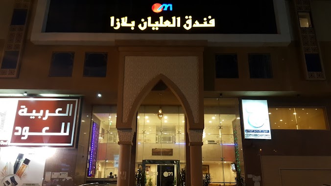
فندق العليان بلازا
7975 طريق المسجد الحرام, Mecca
Lodging
read more
170 m
Olayan Plaza Hotel
Al Masjid Al Haram Road, Mecca
Lodging
read more
171 m
Wahat alumrah
7975 طريق المسجد الحرام، Mecca
Lodging
read more
175 m
اراك التيسير 2
3604 المعرفة، العزيزية مكة 24243
Lodging
read more
177 m
Haya tower
7959 طريق المسجد الحرام, Mecca
Lodging
read more
184 m
Olayan Nusantara
Mecca
Lodging
read more
185 m
Hotel Sweiss
8291 صدقي, Mecca
Lodging
read more
188 m
Hayaa hotel
7959 طريق المسجد الحرام, Mecca
Lodging
read more
188 m
Olayan Nusantara
7935 Al Masjid Al Haram Road, 3423, Saudi Arabia, Mecca
Lodging
read more
189 m
فندق اراك التيسير2
3597-3623, Mecca
Lodging
read more
192 m
فندق جوهرة الانصار
7998, 3579, Mecca
Lodging
read more
193 m
فندق الهداية الكبرى
7935 طريق المسجد الحرام, Mecca
Lodging
read more
197 m
فندق شهد العزیزیه
Mecca
Lodging
read more
197 m
فندق الابرار
Al Masjid Al Haram Road, Mecca
Lodging
read more
📑
all categories
Accounting
Administrative area level 1
Airport
Amusement park
Aquarium
Art gallery
Atm
Bakery
Bank
Bar
Beauty salon
Bicycle store
Book store
Bowling alley
Bus station
Cafe
Campground
Car dealer
Car rental
Car repair
Car wash
Casino
Cemetery
Church
City hall
Clothing store
Colloquial area
Convenience store
Country
Courthouse
Dentist
Department store
Doctor
Electrician
Electronics store
Embassy
Finance
Fire station
Florist
Food
Funeral home
Furniture store
Gas station
General contractor
Grocery or supermarket
Gym
Hair care
Hardware store
Health
Hindu Temple
Home goods store
Hospital
Insurance agency
Intersection
Jewelry store
Laundry
Lawyer
Library
Light rail station
Liquor store
Local government office
Locality
Locksmith
Lodging
Meal delivery
Meal takeaway
Mosque
Movie rental
Movie theater
Moving company
Museum
Natural feature
Neighborhood
Night club
Painter
Park
Parking
Pet store
Pharmacy
Physiotherapist
Place of worship
Plumber
Point of interest
Police
Political
Post office
Premise
Real estate agency
Restaurant
Roofing contractor
Route
Rv park, camping
School
Shoe store
Shopping mall
Spa
Stadium
Storage
Store
Sublocality
Subpremise
Subway station
Supermarket
Taxi stand
Train station
Transit station
Travel agency
University
Veterinary care
Zoo
sublocality level 1
↑