Lodging nearby Friends Resort
Saudi Arabia
Lodging nearby Friends Resort
Friends Resort
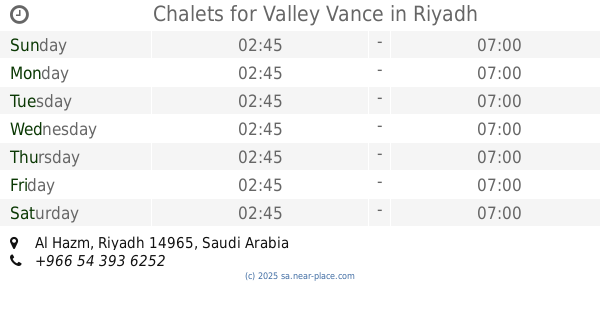
2935, Al Hazm, Riyadh 14966 8194, Saudi Arabia
contacts phone
:
+966
Latitude:
24.5302338
, Longitude:
46.6340215
larger map & directions
read more
nearest Lodging
345 m
الشالية
3386, Riyadh
Lodging
read more
369 m
شالية أبوسليمان
Riyadh
Lodging
read more
370 m
ELEGNT CHALETS
3689, Riyadh
Lodging
read more
415 m
Chalets for Valley Vance
Riyadh
Lodging
read more
435 m
Packages camp
3689, Riyadh
Lodging
read more
532 m
استراحة النخيل
8110 القويمية, Riyadh
Lodging
read more
577 m
الأستراحة
Riyadh
Lodging
read more
607 m
شاليه الفخم
Riyadh
Lodging
read more
646 m
استراحة الدباخ
Riyadh
Lodging
read more
649 m
استراحة الزقمبية
Unnamed Road, Riyadh
Lodging
read more
824 m
منزل واستراحة الشيخ محمد بن سعد ال عظيمان
3775 Al Qalyb, Riyadh
Lodging
read more
896 m
استراحه المطاليق
7471 Muhammad Ibn Awjan, Riyadh
Lodging
read more
964 m
شاليهات نارسيسيا
Riyadh
Lodging
read more
1.077 km
شقة الحزم - الرياض
Unnamed Road, Riyadh
Lodging
read more
1.148 km
إستراحة صحاري
Al Quaiaiyah, Riyadh
Lodging
read more
1.247 km
شاليهات لمار
Ali Ibn An Naqib, Riyadh
Lodging
read more
1.261 km
KINDER’s apartment
Riyadh
Lodging
read more
1.332 km
إستراحة الجميل
Ali Ibn An Naqib, Riyadh
Lodging
read more
1.461 km
استراحة شلقى
4277 Al Kadadiyah, Riyadh
Lodging
read more
1.474 km
Olympic chalets
6911-6935 Al Majzal, Riyadh
Lodging
read more
1.507 km
أستراحة الخالدية
4429 Al Karimi, 8456, Riyadh
Lodging
read more
1.512 km
Evian Chalets
4319 Al Qalyb, Riyadh
Lodging
read more
1.531 km
استراحة سحاب بالحزم
7005, Riyadh
Lodging
read more
1.611 km
راحتي الشقق الفندقيه المروشه حي الحزم
شارع Ali Ibn An Naqib, Riyadh
Lodging
read more
1.613 km
شقق راحتي للوحدات السكنية المفروشة
المؤذن Al Muazin, Riyadh
Lodging
read more
📑
all categories
Accounting
Administrative area level 1
Airport
Amusement park
Aquarium
Art gallery
Atm
Bakery
Bank
Bar
Beauty salon
Bicycle store
Book store
Bowling alley
Bus station
Cafe
Campground
Car dealer
Car rental
Car repair
Car wash
Casino
Cemetery
Church
City hall
Clothing store
Colloquial area
Convenience store
Country
Courthouse
Dentist
Department store
Doctor
Electrician
Electronics store
Embassy
Finance
Fire station
Florist
Food
Funeral home
Furniture store
Gas station
General contractor
Grocery or supermarket
Gym
Hair care
Hardware store
Health
Hindu Temple
Home goods store
Hospital
Insurance agency
Intersection
Jewelry store
Laundry
Lawyer
Library
Light rail station
Liquor store
Local government office
Locality
Locksmith
Lodging
Meal delivery
Meal takeaway
Mosque
Movie rental
Movie theater
Moving company
Museum
Natural feature
Neighborhood
Night club
Painter
Park
Parking
Pet store
Pharmacy
Physiotherapist
Place of worship
Plumber
Point of interest
Police
Political
Post office
Premise
Real estate agency
Restaurant
Roofing contractor
Route
Rv park, camping
School
Shoe store
Shopping mall
Spa
Stadium
Storage
Store
Sublocality
Subpremise
Subway station
Supermarket
Taxi stand
Train station
Transit station
Travel agency
University
Veterinary care
Zoo
sublocality level 1
↑