Lodging nearby لبالي رهام للاجنحة الفندقية
Saudi Arabia
Lodging nearby لبالي رهام للاجنحة الفندقية
لبالي رهام للاجنحة الفندقية
العزيزية،, Riyadh Saudi Arabia
contacts phone
:
+966
Latitude:
24.5912722
, Longitude:
46.7688756
read more
nearest Lodging
391 m
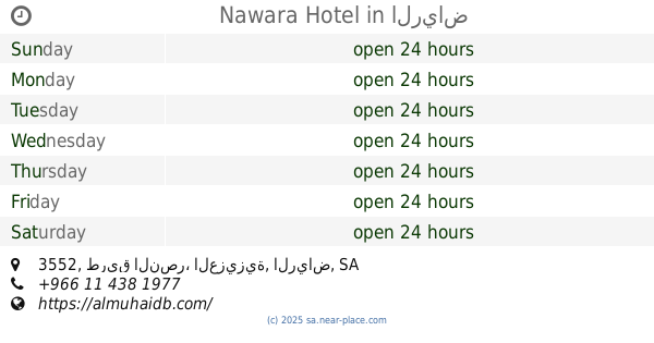
Nawara Hotel
3552 طريق النصر، العزيزية، الرياض
Lodging
read more
391 m
Nawara Hotel
3552 طريق النصر، العزيزية, Riyadh
Lodging
read more
534 m
Dary Furnished Apartments 3
Al Aziziyah Dist. Al Shabab St., Riyadh
Lodging
read more
553 m
ملحق ال سعيّد
شارع شط القاعة،، الرياض
Lodging
read more
626 m
طلائع الدانه للوحدات السكنية المفروشة
9460 طريق العزيزية، العزيزية الرياض 14514
Lodging
read more
705 m
حي الموسى تندحة
Tendaha
Lodging
read more
877 m
Zahret Lamar Aparthotel
3810, Riyadh
Lodging
read more
888 m
Sultan bin Mishaal bin Sultan Al Nafjan
عبدالرحمن بن عودان, Riyadh
Lodging
read more
958 m
Hla and spite 2
Riyadh
Lodging
read more
963 m
Hala W Ghala2 Hotel
Al Rabat, Riyadh
Lodging
read more
997 m
The House Hotel Azizia
6427 Shabab, Riyadh
Lodging
read more
1.007 km
دارك المتقدمة للوحدات السكنية المفروشة فرع(2)
الشباب Shabab, Riyadh
Lodging
read more
1.022 km
زهرة لمار
Shabab, Riyadh
Lodging
read more
1.052 km
Mohamadia Apartment
4797 An Namas, Riyadh
Lodging
read more
1.122 km
Qusor Alaziziya Apartments
Al Shabab Street, Riyadh
Lodging
read more
1.158 km
فندق الاهرام
7291, Riyadh
Lodging
read more
1.158 km
ام عبد الله العزيزية
الرياض
Lodging
read more
1.19 km
فندق مندرين الشرق
Lodging
read more
1.22 km
Qasr Al Azizia
Shabab, Riyadh
Lodging
read more
1.24 km
Alaziziah Palaces For Furnished Residential Units
Shabab, Riyadh
Lodging
read more
1.26 km
نزل الشارقة
4188 علي المنتصر التونسي, Riyadh
Lodging
read more
1.278 km
شقق أعالي السحاب
7461, Riyadh
Lodging
read more
1.292 km
Al Dossary Supermarket
4173 ابي عبدالله الزواوي، الرياض
Lodging
read more
1.293 km
الاوركيد للوحدات السكنية
8220 علي المنتصر التونسي, 4472,, Riyadh
Lodging
read more
1.302 km
كيان الجوهرة للعقارات
Mohammad Rashid Rida Mohammad Rashid Rida, Riyadh
Lodging
read more
📑
all categories
Accounting
Administrative area level 1
Airport
Amusement park
Aquarium
Art gallery
Atm
Bakery
Bank
Bar
Beauty salon
Bicycle store
Book store
Bowling alley
Bus station
Cafe
Campground
Car dealer
Car rental
Car repair
Car wash
Casino
Cemetery
Church
City hall
Clothing store
Colloquial area
Convenience store
Country
Courthouse
Dentist
Department store
Doctor
Electrician
Electronics store
Embassy
Finance
Fire station
Florist
Food
Funeral home
Furniture store
Gas station
General contractor
Grocery or supermarket
Gym
Hair care
Hardware store
Health
Hindu Temple
Home goods store
Hospital
Insurance agency
Intersection
Jewelry store
Laundry
Lawyer
Library
Light rail station
Liquor store
Local government office
Locality
Locksmith
Lodging
Meal delivery
Meal takeaway
Mosque
Movie rental
Movie theater
Moving company
Museum
Natural feature
Neighborhood
Night club
Painter
Park
Parking
Pet store
Pharmacy
Physiotherapist
Place of worship
Plumber
Point of interest
Police
Political
Post office
Premise
Real estate agency
Restaurant
Roofing contractor
Route
Rv park, camping
School
Shoe store
Shopping mall
Spa
Stadium
Storage
Store
Sublocality
Subpremise
Subway station
Supermarket
Taxi stand
Train station
Transit station
Travel agency
University
Veterinary care
Zoo
sublocality level 1
↑