Lodging nearby منتجع نورسين
Saudi Arabia
Lodging nearby منتجع نورسين
منتجع نورسين
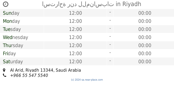
Unnamed Road, Al Arid, Riyadh 13352, Saudi Arabia
contacts phone
:
+966 53 332 8666
Latitude:
24.90782
, Longitude:
46.605923
larger map & directions
read more
nearest Lodging
435 m
Chalets conscience for rent daily
Unnamed Road, Riyadh
Lodging
read more
470 m
Chalets gray stone
Riyadh
Lodging
read more
475 m
Diamond Resort
Riyadh
Lodging
read more
570 m
استراحة اللوتس للإيجار اليومي
Riyadh
Lodging
read more
573 m
Chalets Majestic
King Abdulaziz Road, Riyadh
Lodging
read more
606 m
Chalets de Hafland
Unnamed Road, Riyadh
Lodging
read more
650 m
شاليهات سارة للإيجار اليومي
Unnamed Road, Riyadh
Lodging
read more
730 m
شاليهات حدائق الملكة
King Abdulaziz Road, Riyadh
Lodging
read more
730 m
شاليهات حدائق الملكة
King Abdulaziz Road, Al Arid، الرياض
Lodging
read more
767 m
استراحة الجوهرة المشعة
King Abdulaziz Road, Riyadh
Lodging
read more
774 m
شاليه هلا
Unnamed Road, Riyadh
Lodging
read more
828 m
Chalet Rimda
Riyadh
Lodging
read more
1000 m
Chalet ali
Riyadh
Lodging
read more
1.072 km
Chalets Versailles
Riyadh
Lodging
read more
1.312 km
استراحة السحاب للإيجار اليومي
Riyadh
Lodging
read more
1.366 km
شاليهات ريستو
Riyadh
Lodging
read more
1.377 km
شاليهات بلاتينيوم
Riyadh
Lodging
read more
1.396 km
Vera Chalets
Riyadh
Lodging
read more
1.494 km
شقق تيران الملفا
Nawar Valley, Riyadh
Lodging
read more
1.518 km
شاليهات أرياف
Unnamed Road, Riyadh
Lodging
read more
1.54 km
شاليه انيجما
شاليه انيجما
Lodging
read more
1.701 km
استراحة رند للمناسبات
Riyadh
Lodging
read more
1.705 km
شاليهات ساند بانك
امتداد طريق القصيم مخرج 5 قوات الامن الخاصه حي الامانه, Riyadh
Lodging
read more
1.711 km
شاليهات لافلور
Riyadh
Lodging
read more
1.741 km
Chalets park singing
Riyadh
Lodging
read more
📑
all categories
Accounting
Administrative area level 1
Airport
Amusement park
Aquarium
Art gallery
Atm
Bakery
Bank
Bar
Beauty salon
Bicycle store
Book store
Bowling alley
Bus station
Cafe
Campground
Car dealer
Car rental
Car repair
Car wash
Casino
Cemetery
Church
City hall
Clothing store
Colloquial area
Convenience store
Country
Courthouse
Dentist
Department store
Doctor
Electrician
Electronics store
Embassy
Finance
Fire station
Florist
Food
Funeral home
Furniture store
Gas station
General contractor
Grocery or supermarket
Gym
Hair care
Hardware store
Health
Hindu Temple
Home goods store
Hospital
Insurance agency
Intersection
Jewelry store
Laundry
Lawyer
Library
Light rail station
Liquor store
Local government office
Locality
Locksmith
Lodging
Meal delivery
Meal takeaway
Mosque
Movie rental
Movie theater
Moving company
Museum
Natural feature
Neighborhood
Night club
Painter
Park
Parking
Pet store
Pharmacy
Physiotherapist
Place of worship
Plumber
Point of interest
Police
Political
Post office
Premise
Real estate agency
Restaurant
Roofing contractor
Route
Rv park, camping
School
Shoe store
Shopping mall
Spa
Stadium
Storage
Store
Sublocality
Subpremise
Subway station
Supermarket
Taxi stand
Train station
Transit station
Travel agency
University
Veterinary care
Zoo
sublocality level 1
↑