Lodging nearby PRO 4 Residence
Saudi Arabia
Lodging nearby PRO 4 Residence
PRO 4 Residence
Prince Sultan Road, 34235, Al Khobar, SA Arabia Saudita
contacts phone
:
+966 54 804 8666
website:
www.pro-sa.org
Latitude:
26.3365406
, Longitude:
50.1979584
larger map & directions
read more
nearest Lodging
496 m
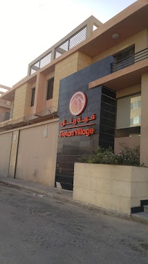
Retan Village
Unnamed Road, Al Khobar
Lodging
read more
602 m
Smsa 1
Al Khobar
Lodging
read more
609 m
Radium Residential Compound V
P.O Box 76520, Al Khobar
Lodging
read more
625 m
Verticle Garden
Uthman Ibn Madhun, 2402 8969, Al Khobar
Lodging
read more
644 m
فندق راديسون بلو RADESON BLUE
Al Khobar
Lodging
read more
839 m
Rezayat Residential Complex
Al Khobar
Lodging
read more
849 m
Alsaeed 1 plus
6238 هارون الخطيب, Al Khobar
Lodging
read more
853 m
Staybridge Suites Al Khobar
King Fahd Road, Al Khobar
Lodging
read more
854 m
Danah Compound مجمع الدانه السكني
الروابي،, Al Khobar
Lodging
read more
912 m
AL RAWABI COMPOUND
Al Khobar
Lodging
read more
926 m
HE Dr. / Abdullah Bin Rashid Al Dosari Aldmuk
Al Khobar
Lodging
read more
959 m
Al-Saeed Village II
6460 داوود بن نصير، Al Khobar
Lodging
read more
1.035 km
Oasis Guesthouse (Korean)
Al Khobar
Lodging
read more
1.039 km
Residence AR
Al Khobar
Lodging
read more
1.043 km
Florence Campound
Andalus Street, Al Khobar
Lodging
read more
1.075 km
EURO INN
3478 انس بن عباد, Al Khobar
Lodging
read more
1.092 km
Atco Compound
Unnamed Road, Al Khobar
Lodging
read more
1.176 km
Lotus Compound
Unnamed Road, Al Khobar
Lodging
read more
1.201 km
Macro Gardens
Ibn Al Watheq, Al Khobar
Lodging
read more
1.265 km
مجمع اليمامة السكني
طريق الأمير سلطان Prince Sultan Road, Al Khobar
Lodging
read more
1.296 km
Nesma Village, Al Khobar
Al Quds Street, Al Jawharah, Al Khobar
Lodging
read more
1.305 km
GMC Al Khober
Al Khobar
Lodging
read more
1.309 km
Rezayat Minimotel
Salaheddin Al Ayoubi Street, Al Khobar
Lodging
read more
1.358 km
Rezayat Palms
3709, 8525, Al Khobar
Lodging
read more
1.424 km
كامبوند السعيد 4
7250-7138 ابن الواثق،, Al Khobar
Lodging
read more
📑
all categories
Accounting
Administrative area level 1
Airport
Amusement park
Aquarium
Art gallery
Atm
Bakery
Bank
Bar
Beauty salon
Bicycle store
Book store
Bowling alley
Bus station
Cafe
Campground
Car dealer
Car rental
Car repair
Car wash
Casino
Cemetery
Church
City hall
Clothing store
Colloquial area
Convenience store
Country
Courthouse
Dentist
Department store
Doctor
Electrician
Electronics store
Embassy
Finance
Fire station
Florist
Food
Funeral home
Furniture store
Gas station
General contractor
Grocery or supermarket
Gym
Hair care
Hardware store
Health
Hindu Temple
Home goods store
Hospital
Insurance agency
Intersection
Jewelry store
Laundry
Lawyer
Library
Light rail station
Liquor store
Local government office
Locality
Locksmith
Lodging
Meal delivery
Meal takeaway
Mosque
Movie rental
Movie theater
Moving company
Museum
Natural feature
Neighborhood
Night club
Painter
Park
Parking
Pet store
Pharmacy
Physiotherapist
Place of worship
Plumber
Point of interest
Police
Political
Post office
Premise
Real estate agency
Restaurant
Roofing contractor
Route
Rv park, camping
School
Shoe store
Shopping mall
Spa
Stadium
Storage
Store
Sublocality
Subpremise
Subway station
Supermarket
Taxi stand
Train station
Transit station
Travel agency
University
Veterinary care
Zoo
sublocality level 1
↑