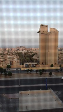
Lodging nearby سكن الامن العام بجدة
Saudi Arabia
Lodging nearby سكن الامن العام بجدة
سكن الامن العام بجدة
7900, Al Marwah District, Jeddah Saudi Arabia
contacts phone
:
+966
Latitude:
21.6170659
, Longitude:
39.2029474
read more
nearest Lodging
243 m
Layali Al Fayrouz Hotel Apartments 1
Almarwah District, Jeddah
Lodging
read more
366 m
اسكان قوى الامن الداخلي جده
Prince Mutaib bin Abdulaziz Road, Jeddah
Lodging
read more
591 m
Manazil AlDhayf
عامر بن أبي ربيعة, Al Marwa District, Heraa Street, Jeddah
Lodging
read more
591 m
Amarena ApartHotel
Almarwa district, Jeddah
Lodging
read more
661 m
TOOT HOUSE JEDDAH
Jeddah
Lodging
read more
666 m
وصيفة جدة 2 للوحدات السكنية
حي المروة، جدة
Lodging
read more
667 m
الميرال الذهبي للشقق الفندقية
Hira Street, Jeddah
Lodging
read more
670 m
2 Nights Turquoise Hotel Suites
ابن اسعد البلنسي، حي المروة, Jeddah
Lodging
read more
692 m
The Artisan Hotel
3894 حراء، جدة
Lodging
read more
699 m
Mashafi Al Saudia
masafi al saudia sharafiyah dist, Al Madina Road, Al Khayyat Road,, Jeddah
Lodging
read more
713 m
Aldeafah Palace
Hira Street, Al Marwah، جدة
Lodging
read more
741 m
البيوتات المتطورة
Hira Street, Jeddah
Lodging
read more
753 m
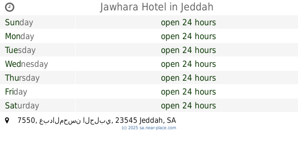
Jawhara Hotel
7550 عبدالمحسن الحلبي, حي المروة، 4837, Jeddah
Lodging
read more
768 m
شقة ايمن
جدة
Lodging
read more
770 m
Ahla Makan Furnished Apartements
Hira Street, Jeddah
Lodging
read more
772 m
Al-abha Furnished Apartements
Hira Street, Jeddah
Lodging
read more
780 m
Esnad Haramain branch
عبد الرحمن الخزاعي, Jeddah
Lodging
read more
780 m
مشغل إكليل الماسة
Jeddah
Lodging
read more
784 m
آصال شقق فندقية
شارع حراء،, Jeddah
Lodging
read more
790 m
hayat in
4607 وادي الخمس, حي المروة،, Jeddah
Lodging
read more
791 m
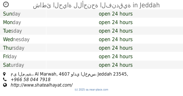
شاطئ الحياة للأجنحة الفندقية
حي المروة،, 4607 وادي الخمس, Jeddah
Lodging
read more
792 m
اسناد للوحدات السكنية
عبدالرحمن الخزاعي
Lodging
read more
809 m
Shathunul Hayat
Al Manini, Jeddah
Lodging
read more
820 m
اسناد للوحدات المفروشه
Jeddah
Lodging
read more
866 m
Lulu Marwa Staff Accommodation
Jeddah
Lodging
read more
📑
all categories
Accounting
Administrative area level 1
Airport
Amusement park
Aquarium
Art gallery
Atm
Bakery
Bank
Bar
Beauty salon
Bicycle store
Book store
Bowling alley
Bus station
Cafe
Campground
Car dealer
Car rental
Car repair
Car wash
Casino
Cemetery
Church
City hall
Clothing store
Colloquial area
Convenience store
Country
Courthouse
Dentist
Department store
Doctor
Electrician
Electronics store
Embassy
Finance
Fire station
Florist
Food
Funeral home
Furniture store
Gas station
General contractor
Grocery or supermarket
Gym
Hair care
Hardware store
Health
Hindu Temple
Home goods store
Hospital
Insurance agency
Intersection
Jewelry store
Laundry
Lawyer
Library
Light rail station
Liquor store
Local government office
Locality
Locksmith
Lodging
Meal delivery
Meal takeaway
Mosque
Movie rental
Movie theater
Moving company
Museum
Natural feature
Neighborhood
Night club
Painter
Park
Parking
Pet store
Pharmacy
Physiotherapist
Place of worship
Plumber
Point of interest
Police
Political
Post office
Premise
Real estate agency
Restaurant
Roofing contractor
Route
Rv park, camping
School
Shoe store
Shopping mall
Spa
Stadium
Storage
Store
Sublocality
Subpremise
Subway station
Supermarket
Taxi stand
Train station
Transit station
Travel agency
University
Veterinary care
Zoo
sublocality level 1
↑