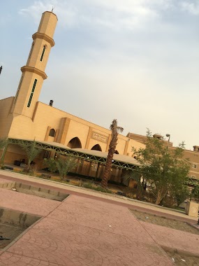
Mosque nearby جامع الفلاح
Saudi Arabia
Mosque nearby جامع الفلاح
جامع الفلاح
3632, حي الحمدانية، 8046, Jeddah Saudi Arabien
contacts phone
:
+966
Latitude:
21.7666431
, Longitude:
39.1933263
read more
nearest Mosque
294 m
Bara bin Malik al-Ansari Masjed
saeed Al Majid, Riyadh
Mosque
read more
297 m
جامع البراء بن مالك الأنصاري
3571, حي الحمدانية،, Jeddah
Mosque
read more
463 m
مسجد سيد الشهداء
3230, حي الحمدانية 7896, Jeddah
Mosque
read more
511 m
مسجد النور
Unnamed Road, الفلاح،, Jeddah
Mosque
read more
536 m
مسجد التوحيد. حي الماجد. الحمدانية
7657, Al Hamadaniyah District, Jeddah
Mosque
read more
546 m
جامع السنة
Jeddah
Mosque
read more
548 m
مسجد التقوى
7657, Al Hamadaniyah District, Jeddah
Mosque
read more
566 m
Tawhid Mosque Balmagd -ahamdanah
7657, حي الحمدانية،, Jeddah
Mosque
read more
826 m
مسجد الحمد
7366, Al Hamadaniyah District, 4101, Jeddah
Mosque
read more
887 m
Dhaoui Aldhas Mosque
Jeddah
Mosque
read more
892 m
مسجد الفرقان وعمدة الصالحية
Jeddah
Mosque
read more
989 m
Abdullah bin Habib Mosque peaceful
Jeddah
Mosque
read more
1.027 km
مسجد سحيم بن سعيد الغامدي
3753 Al Hamadaniyah District Jeddah 23761
Mosque
read more
1.035 km
ابو عبيدة عامر بن الجراح
Al-Hamadaniyah
Mosque
read more
1.035 km
ابو عبيدة عامر بن الجراح
Al Hamadaniyyah
Mosque
read more
1.042 km
Saad bin Maaz may Allah be pleased with him mosque
7038, حي الفلاح, Jeddah
Mosque
read more
1.257 km
Taqwa Mosque
Jeddah
Mosque
read more
1.275 km
مسجد بلال بن رباح
2482, حي الصالحية, Jeddah
Mosque
read more
1.321 km
Um Mutlaq Mosque
Jeddah
Mosque
read more
1.397 km
Almsaudy Mosque
7119, Al Falah District, Jeddah
Mosque
read more
1.477 km
Muawiya ibn Abi Sufyan mosque
Jeddah
Mosque
read more
1.482 km
Alsroor Mosque
الفروسية, Jeddah
Mosque
read more
1.484 km
مسجد محطة السلمي
6820, حي الحمدانية, Jeddah
Mosque
read more
1.561 km
جامع الرحمة
6965, As Salhiyah District, Jeddah
Mosque
read more
1.564 km
مسجد
Al-Salehiyah
Mosque
read more
📑
all categories
Accounting
Administrative area level 1
Airport
Amusement park
Aquarium
Art gallery
Atm
Bakery
Bank
Bar
Beauty salon
Bicycle store
Book store
Bowling alley
Bus station
Cafe
Campground
Car dealer
Car rental
Car repair
Car wash
Casino
Cemetery
Church
City hall
Clothing store
Colloquial area
Convenience store
Country
Courthouse
Dentist
Department store
Doctor
Electrician
Electronics store
Embassy
Finance
Fire station
Florist
Food
Funeral home
Furniture store
Gas station
General contractor
Grocery or supermarket
Gym
Hair care
Hardware store
Health
Hindu Temple
Home goods store
Hospital
Insurance agency
Intersection
Jewelry store
Laundry
Lawyer
Library
Light rail station
Liquor store
Local government office
Locality
Locksmith
Lodging
Meal delivery
Meal takeaway
Mosque
Movie rental
Movie theater
Moving company
Museum
Natural feature
Neighborhood
Night club
Painter
Park
Parking
Pet store
Pharmacy
Physiotherapist
Place of worship
Plumber
Point of interest
Police
Political
Post office
Premise
Real estate agency
Restaurant
Roofing contractor
Route
Rv park, camping
School
Shoe store
Shopping mall
Spa
Stadium
Storage
Store
Sublocality
Subpremise
Subway station
Supermarket
Taxi stand
Train station
Transit station
Travel agency
University
Veterinary care
Zoo
sublocality level 1
↑