Mosque nearby جامع الشيخ عبدالعزيز بن محمد العثمان
Saudi Arabia
Mosque nearby جامع الشيخ عبدالعزيز بن محمد العثمان
جامع الشيخ عبدالعزيز بن محمد العثمان
Al Hamra, Riyadh 13216, Saudi Arabia
contacts phone
:
+966
Latitude:
24.7715093
, Longitude:
46.7475075
larger map & directions
read more
nearest Mosque
342 m
Abu Ayyub Alansari Mosque
Abdulrahman al Faqih, Riyadh
Mosque
read more
386 m
Anas Ibn Malik Mosque
Riyadh
Mosque
read more
479 m
مسجد الرويلي
3938 Khallad, Riyadh
Mosque
read more
568 m
مسجد زيد المسلَّم
7857 التمار, 3732, Riyadh
Mosque
read more
570 m
مسجد الشيخ محمد بن صالح الغليقة
7102 الياسمين الغدير, Riyadh
Mosque
read more
626 m
مسجد الفوزان
6680 Al Yatimah, Riyadh
Mosque
read more
640 m
مسجد الإيمان
7498 الدوحة, Riyadh
Mosque
read more
694 m
Ehsan mosque
شارع الحناكية, Riyadh
Mosque
read more
772 m
مسجد مؤقت Mosque
Riyadh
Mosque
read more
826 m
لولوة بنت عبد الله الروماف يغفرالله لها
شارع خالد بن الوليد، حي الحمراء، الرياض
Mosque
read more
835 m
مصلى نساء
شارع خالد بن الوليد، حي الحمراء، الرياض
Mosque
read more
849 m
جامع الغويري Mosque
البيان, Riyadh
Mosque
read more
860 m
Aisha mosque
Abi al Qasim Ash Sharif, Riyadh
Mosque
read more
865 m
مسجد لولوة بنت سليمان المديهيم
King Abdullah Branch Road, Riyadh
Mosque
read more
971 m
جامع الاميرة حصه بنت عبد العزيز
Al Hamra
Mosque
read more
980 m
Ahmed bin Hanbal neighborhood of Hamra East Mosque
2633 البشائر, Riyadh
Mosque
read more
985 m
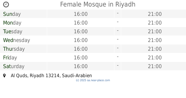
Female Mosque
Riyadh
Mosque
read more
1.007 km
جامع الإمام البخاري
Riyadh
Mosque
read more
1.039 km
مسجد الدكتور / مترك الجعيد رحمه الله
6873 المروج, 2775, Riyadh
Mosque
read more
1.072 km
مسجد المحسين
8208 At Taj, Al Hamra Riyadh 13216
Mosque
read more
1.086 km
Ghaith mosque
البيان, Riyadh
Mosque
read more
1.09 km
مسجد عمر بن عبدالعزيز
Al Quds
Mosque
read more
1.139 km
جامع يحي بن معين
2607 الجود, Riyadh
Mosque
read more
1.143 km
جامع الحمراء الغربية
2607 الجود, Riyadh
Mosque
read more
1.144 km
مسجد خبيب بن عدي رضي الله عنه
2813 Imam Abdullah Ibn Saud Ibn Abdulaziz Branch Road, Riyadh
Mosque
read more
📑
all categories
Accounting
Administrative area level 1
Airport
Amusement park
Aquarium
Art gallery
Atm
Bakery
Bank
Bar
Beauty salon
Bicycle store
Book store
Bowling alley
Bus station
Cafe
Campground
Car dealer
Car rental
Car repair
Car wash
Casino
Cemetery
Church
City hall
Clothing store
Colloquial area
Convenience store
Country
Courthouse
Dentist
Department store
Doctor
Electrician
Electronics store
Embassy
Finance
Fire station
Florist
Food
Funeral home
Furniture store
Gas station
General contractor
Grocery or supermarket
Gym
Hair care
Hardware store
Health
Hindu Temple
Home goods store
Hospital
Insurance agency
Intersection
Jewelry store
Laundry
Lawyer
Library
Light rail station
Liquor store
Local government office
Locality
Locksmith
Lodging
Meal delivery
Meal takeaway
Mosque
Movie rental
Movie theater
Moving company
Museum
Natural feature
Neighborhood
Night club
Painter
Park
Parking
Pet store
Pharmacy
Physiotherapist
Place of worship
Plumber
Point of interest
Police
Political
Post office
Premise
Real estate agency
Restaurant
Roofing contractor
Route
Rv park, camping
School
Shoe store
Shopping mall
Spa
Stadium
Storage
Store
Sublocality
Subpremise
Subway station
Supermarket
Taxi stand
Train station
Transit station
Travel agency
University
Veterinary care
Zoo
sublocality level 1
↑