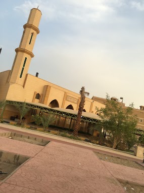
Mosque nearby مسجد الايمان
Saudi Arabia
Mosque nearby مسجد الايمان
مسجد الايمان
حي الحمدانية، Al-Hamadaniyah, Jeddah 23743 3716, Saudi Arabia
contacts phone
:
+966
Latitude:
21.7520535
, Longitude:
39.2007313
larger map & directions
read more
nearest Mosque
223 m
مسجد عبداللطيف ونفيسه
4282, Al Hamadaniyah District, Jeddah
Mosque
read more
538 m
Taqwa Mosque
Jeddah
Mosque
read more
606 m
مسجد
Al-Hamadaniyah
Mosque
read more
606 m
مسجد
Al Hamadaniyyah
Mosque
read more
617 m
جامع الهجرة
4803, حي الحمدانية، 6902, Jeddah
Mosque
read more
732 m
مسجد الوفاء
جدة
Mosque
read more
738 m
Muawiya ibn Abi Sufyan mosque
Jeddah
Mosque
read more
886 m
مسجد سحيم بن سعيد الغامدي
3753 Al Hamadaniyah District Jeddah 23761
Mosque
read more
975 m
مسجد الحمد
7366, Al Hamadaniyah District, 4101, Jeddah
Mosque
read more
1.013 km
ابو عبيدة عامر بن الجراح
Al Hamadaniyyah
Mosque
read more
1.013 km
ابو عبيدة عامر بن الجراح
Al-Hamadaniyah
Mosque
read more
1.05 km
Bandar bin Humaid Mosque
Jeddah
Mosque
read more
1.056 km
جامع بندر بن حميد
Unnamed Road, الحمدانية،, Jeddah
Mosque
read more
1.116 km
Abu Bakr mosque
6473, حي الصالحية, Jeddah
Mosque
read more
1.14 km
Mosque Althakreen
Jeddah
Mosque
read more
1.154 km
جامع الخير
Jeddah
Mosque
read more
1.173 km
مسجد
Al-Salehiyah
Mosque
read more
1.173 km
مسجد أهلي
Jeddah
Mosque
read more
1.178 km
Alguraigri Mosque
Al-Salehiyah, Al-Salehiyah Road، جدة
Mosque
read more
1.179 km
مسجد مقبرة الصالحيه
4859, حي الصالحية،, Jeddah
Mosque
read more
1.181 km
جامع الرحمة
6965, As Salhiyah District, Jeddah
Mosque
read more
1.255 km
Tawhid Mosque Balmagd -ahamdanah
7657, حي الحمدانية،, Jeddah
Mosque
read more
1.262 km
Um Mutlaq Mosque
Jeddah
Mosque
read more
1.276 km
مسجد التقوى
7657, Al Hamadaniyah District, Jeddah
Mosque
read more
1.292 km
مسجد التوحيد. حي الماجد. الحمدانية
7657, Al Hamadaniyah District, Jeddah
Mosque
read more
📑
all categories
Accounting
Administrative area level 1
Airport
Amusement park
Aquarium
Art gallery
Atm
Bakery
Bank
Bar
Beauty salon
Bicycle store
Book store
Bowling alley
Bus station
Cafe
Campground
Car dealer
Car rental
Car repair
Car wash
Casino
Cemetery
Church
City hall
Clothing store
Colloquial area
Convenience store
Country
Courthouse
Dentist
Department store
Doctor
Electrician
Electronics store
Embassy
Finance
Fire station
Florist
Food
Funeral home
Furniture store
Gas station
General contractor
Grocery or supermarket
Gym
Hair care
Hardware store
Health
Hindu Temple
Home goods store
Hospital
Insurance agency
Intersection
Jewelry store
Laundry
Lawyer
Library
Light rail station
Liquor store
Local government office
Locality
Locksmith
Lodging
Meal delivery
Meal takeaway
Mosque
Movie rental
Movie theater
Moving company
Museum
Natural feature
Neighborhood
Night club
Painter
Park
Parking
Pet store
Pharmacy
Physiotherapist
Place of worship
Plumber
Point of interest
Police
Political
Post office
Premise
Real estate agency
Restaurant
Roofing contractor
Route
Rv park, camping
School
Shoe store
Shopping mall
Spa
Stadium
Storage
Store
Sublocality
Subpremise
Subway station
Supermarket
Taxi stand
Train station
Transit station
Travel agency
University
Veterinary care
Zoo
sublocality level 1
↑