Mosque nearby مسجد الهدى
Saudi Arabia
Mosque nearby مسجد الهدى
مسجد الهدى
2587, As Sufyani, 23326, Jeddah, SA Saudi Arabia
contacts phone
:
+966
Latitude:
21.5492027
, Longitude:
39.1582986
larger map & directions
read more
nearest Mosque
262 m
مصلى
شارع عبد الرحمن الطبيشي، حي الأندلس، جدة
Mosque
read more
434 m
مسجد اللامي
صحوة المستقبل، التحلية، جدة
Mosque
read more
512 m
جامع أبي بكر الصديق
Jeddah
Mosque
read more
634 m
مسجد الامير تركي/ الشيخ محمد الشنقيطي
8249 Hail, Al Andalus District, Jeddah
Mosque
read more
658 m
Al Lami Mosque
Turath Al Fikr, Jeddah
Mosque
read more
842 m
مسجد الأميرة جواهر بنت سلطان
4176 هشام بن حكيم، حي الاندلس، جدة 23322
Mosque
read more
965 m
Bugshan Mosque
Al Ashri, Jeddah
Mosque
read more
1.039 km
Masjid Al-Taqwa 🕌
عبدالله المطري, Jeddah
Mosque
read more
1.082 km
Masjid Rahma
6936 حائل، حي الروضة، جدة 23431 3036 Hail, Jeddah
Mosque
read more
1.083 km
مسجد
2533 Al Hasiri, حي الروضة،, Jeddah
Mosque
read more
1.084 km
Al Rahma Mosque 🕌
Hail, Jeddah
Mosque
read more
1.252 km
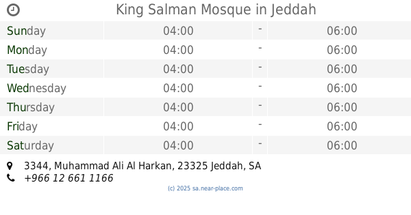
King Salman Mosque
3344 Muhammad Ali Al Harkan, Jeddah
Mosque
read more
1.274 km
مصلى عيادة الهجن
7008 عبدالله العراسي، الروضة،, Jeddah
Mosque
read more
1.327 km
Masjid Sheikh Abdullah Al-Sulaiman Al-Hamdan
Jeddah
Mosque
read more
1.376 km
Mosque AlRajhi
Ar Rashidi, Jeddah
Mosque
read more
1.385 km
Mosque
Al Andalus
Mosque
read more
1.387 km
Abdullah bin Ammar Mosque
Arafat, Jeddah
Mosque
read more
1.407 km
Al Andalus Mosque
Abdullah Balkhayr, Jeddah
Mosque
read more
1.517 km
Mohammed Ibn Abdulaziz Mosque
Al Rawdah
Mosque
read more
1.517 km
Mohammed Ibn Abdulaziz Mosque
Ar Rawdah
Mosque
read more
1.588 km
مسجد النور
رخاء الإسلام، حي الأندلس، جدة
Mosque
read more
1.588 km
Al Noor Mosque
Al Andalus
Mosque
read more
1.667 km
مسجد التوحيد
7677 Ahmad Al Mujahid, AR Rawdah District, Jeddah 23434 3956 Ahmad Al Mujahid, Jeddah
Mosque
read more
1.668 km
masjid sarawat
Jeddah
Mosque
read more
1.672 km
Al Tawheed Mosque
Al Rawdah
Mosque
read more
📑
all categories
Accounting
Administrative area level 1
Airport
Amusement park
Aquarium
Art gallery
Atm
Bakery
Bank
Bar
Beauty salon
Bicycle store
Book store
Bowling alley
Bus station
Cafe
Campground
Car dealer
Car rental
Car repair
Car wash
Casino
Cemetery
Church
City hall
Clothing store
Colloquial area
Convenience store
Country
Courthouse
Dentist
Department store
Doctor
Electrician
Electronics store
Embassy
Finance
Fire station
Florist
Food
Funeral home
Furniture store
Gas station
General contractor
Grocery or supermarket
Gym
Hair care
Hardware store
Health
Hindu Temple
Home goods store
Hospital
Insurance agency
Intersection
Jewelry store
Laundry
Lawyer
Library
Light rail station
Liquor store
Local government office
Locality
Locksmith
Lodging
Meal delivery
Meal takeaway
Mosque
Movie rental
Movie theater
Moving company
Museum
Natural feature
Neighborhood
Night club
Painter
Park
Parking
Pet store
Pharmacy
Physiotherapist
Place of worship
Plumber
Point of interest
Police
Political
Post office
Premise
Real estate agency
Restaurant
Roofing contractor
Route
Rv park, camping
School
Shoe store
Shopping mall
Spa
Stadium
Storage
Store
Sublocality
Subpremise
Subway station
Supermarket
Taxi stand
Train station
Transit station
Travel agency
University
Veterinary care
Zoo
sublocality level 1
↑