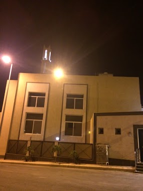
Mosque nearby مسجد عبد الله بن مصلح
Saudi Arabia
Mosque nearby مسجد عبد الله بن مصلح
مسجد عبد الله بن مصلح
3299, Khamis Mushait Saudi Arabia
contacts phone
:
+966
Latitude:
18.3000824
, Longitude:
42.6825845
read more
nearest Mosque
310 m
مسجد ابن حسنية
King Fahd Road
Mosque
read more
371 m
Abd al-Rahman ibn Awf Mosque
3500, 6423, Khamis Mushait
Mosque
read more
581 m
مسجد المحطة
3611 King Fahd Road, Khamis Mushait
Mosque
read more
603 m
مسجد الابوين
Mosque
read more
615 m
مسجد التوبة
7266, Khamis Mushait
Mosque
read more
648 m
مسجد الغروي
King Fahd Road, Khamis Mushait
Mosque
read more
650 m
مسجد الملك فهد
طريق أبها، خميس مشيط
Mosque
read more
676 m
مسجد
طريق أبها، حي الضيافة، خميس مشيط
Mosque
read more
714 m
جامع المنارات
Khamis Mushait
Mosque
read more
725 m
مسجد مستشفي غسان نجيب فرعون
2809, Khamis Mushait
Mosque
read more
735 m
Zaina Ali al Hussaini Mosque
7251, Khamis Mushait
Mosque
read more
749 m
مسجد رياض الصالحين
4927, Khamis Mushait
Mosque
read more
852 m
المسجد
التحلية
Mosque
read more
865 m
Mosque mother of believers Aisha Abu Bakr girl
Mosque
read more
898 m
Alehsaan Mosque
Saudi Arabia
Mosque
read more
921 m
مسجد
King Fahd Road, Khamis Mushait
Mosque
read more
933 m
Mohammed Fatih exhibitions
4991, Khamis Mushait
Mosque
read more
974 m
Exibition Street Mosque
Mosque
read more
1.035 km
King Salman Mosque
2915, Khamis Mushait
Mosque
read more
1.072 km
مسجد
4374 خميس مشيط 62452
Mosque
read more
1.126 km
مسجد الشبلي
7582, 4183,, Khamis Mushait
Mosque
read more
1.144 km
مسجد الابوين
Abha
Mosque
read more
1.284 km
Nora Mosque
4142 7837 حي حسام, Khamis Mushait
Mosque
read more
1.288 km
Umar Bin Khattabh Batarah Misque
8034, Khamis Mushait
Mosque
read more
1.295 km
Mosque of Omar bin Abdul Aziz
6159, Khamis Mushait
Mosque
read more
📑
all categories
Accounting
Administrative area level 1
Airport
Amusement park
Aquarium
Art gallery
Atm
Bakery
Bank
Bar
Beauty salon
Bicycle store
Book store
Bowling alley
Bus station
Cafe
Campground
Car dealer
Car rental
Car repair
Car wash
Casino
Cemetery
Church
City hall
Clothing store
Colloquial area
Convenience store
Country
Courthouse
Dentist
Department store
Doctor
Electrician
Electronics store
Embassy
Finance
Fire station
Florist
Food
Funeral home
Furniture store
Gas station
General contractor
Grocery or supermarket
Gym
Hair care
Hardware store
Health
Hindu Temple
Home goods store
Hospital
Insurance agency
Intersection
Jewelry store
Laundry
Lawyer
Library
Light rail station
Liquor store
Local government office
Locality
Locksmith
Lodging
Meal delivery
Meal takeaway
Mosque
Movie rental
Movie theater
Moving company
Museum
Natural feature
Neighborhood
Night club
Painter
Park
Parking
Pet store
Pharmacy
Physiotherapist
Place of worship
Plumber
Point of interest
Police
Political
Post office
Premise
Real estate agency
Restaurant
Roofing contractor
Route
Rv park, camping
School
Shoe store
Shopping mall
Spa
Stadium
Storage
Store
Sublocality
Subpremise
Subway station
Supermarket
Taxi stand
Train station
Transit station
Travel agency
University
Veterinary care
Zoo
sublocality level 1
↑