Night club nearby قاعه السامر
Saudi Arabia
Night club nearby قاعه السامر
قاعه السامر
6525-6643 نسيبة بنت كعب، السامر،, Jeddah Saudi Arabia
contacts phone
:
+966
Latitude:
21.5876547
, Longitude:
39.2300269
read more
nearest Night club
580 m
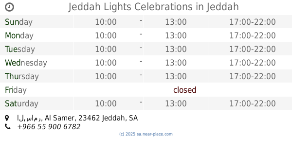
Jeddah Lights Celebrations
السامر Al Samer, 3182-, Jeddah
Night club
read more
1.554 km
Internet Cafe meeting
4517 الشاكرين، حي الصفا جدة 23453 7482 Al-Shakireen, Jeddah
Night club
read more
2.634 km
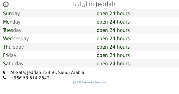
ابانا
Jeddah
Night club
read more
2.705 km
العزبه
Al Samer, Jeddah
Night club
read more
3.57 km
عمارة فايز فلمبان
2460 ابن بنانه السعدي، حي الصفا، جدة 23451 6645،
Night club
read more
3.584 km
صالون البتره
4105-4137 Al Muallifeen Street, Jeddah
Night club
read more
3.959 km
أستراحة الأجواد
Jeddah
Night club
read more
4.151 km
منتجات وسترحه ربيه
Unnamed Road, Jeddah
Night club
read more
4.257 km
عطاء
Jeddah
Night club
read more
4.29 km
snooker club
Unnamed Road, Jeddah
Night club
read more
4.407 km
Hadigah
Jeddah
Night club
read more
4.66 km
الفيحاء
4524-4556 وادي الزرقاء، جدة
Night club
read more
4.918 km
سكن الجوازات
Unnamed Road, Jeddah
Night club
read more
5.011 km
ابو هاشم معدت غوص
2728 Al Manfaluti, Mishrifah District, Jeddah
Night club
read more
5.117 km
ماهر خضري
Unnamed Road, Jeddah
Night club
read more
5.257 km
البوادي للمفروشات
جدةر
Night club
read more
5.414 km
الخيمة الزارعية
جدة
Night club
read more
5.558 km
صالون معرفة خير
2737 حراء, حي المروة, Jeddah
Night club
read more
5.654 km
سوق الستين البودي
King Fahd Road, Jeddah
Night club
read more
5.816 km
مركز بالبيد
سلطان بن سلمان، المروة،, Jeddah
Night club
read more
5.95 km
ملحمة الامجاد
Jeddah
Night club
read more
6.089 km
الشيخ مدني النزاوي
Jeddah
Night club
read more
6.174 km
بيت ابن حطان
8207 الحسين بن سلامة، حي الربوة جدة 23535
Night club
read more
6.335 km
مركاز أبو علي الحسيكي
المروة،, Jeddah
Night club
read more
6.364 km
متجر
الربوة،, Jeddah
Night club
read more
📑
all categories
Accounting
Administrative area level 1
Airport
Amusement park
Aquarium
Art gallery
Atm
Bakery
Bank
Bar
Beauty salon
Bicycle store
Book store
Bowling alley
Bus station
Cafe
Campground
Car dealer
Car rental
Car repair
Car wash
Casino
Cemetery
Church
City hall
Clothing store
Colloquial area
Convenience store
Country
Courthouse
Dentist
Department store
Doctor
Electrician
Electronics store
Embassy
Finance
Fire station
Florist
Food
Funeral home
Furniture store
Gas station
General contractor
Grocery or supermarket
Gym
Hair care
Hardware store
Health
Hindu Temple
Home goods store
Hospital
Insurance agency
Intersection
Jewelry store
Laundry
Lawyer
Library
Light rail station
Liquor store
Local government office
Locality
Locksmith
Lodging
Meal delivery
Meal takeaway
Mosque
Movie rental
Movie theater
Moving company
Museum
Natural feature
Neighborhood
Night club
Painter
Park
Parking
Pet store
Pharmacy
Physiotherapist
Place of worship
Plumber
Point of interest
Police
Political
Post office
Premise
Real estate agency
Restaurant
Roofing contractor
Route
Rv park, camping
School
Shoe store
Shopping mall
Spa
Stadium
Storage
Store
Sublocality
Subpremise
Subway station
Supermarket
Taxi stand
Train station
Transit station
Travel agency
University
Veterinary care
Zoo
sublocality level 1
↑