Pharmacy nearby AL DAWAA alelmi pharmacy
Saudi Arabia
Pharmacy nearby AL DAWAA alelmi pharmacy
AL DAWAA alelmi pharmacy
شارع الأمير سعود بن عبدالمحسن آل سعود, 55436, Hail, SA Saudi Arabia
contacts phone
:
+966 59 857 6897
Latitude:
27.4634358
, Longitude:
41.6387107
larger map & directions
read more
nearest Pharmacy
430 m
صيدلية الدواء الأولى
Hail
Pharmacy
read more
516 m
Pharmacy Aloloh
Hail
Pharmacy
read more
1.342 km
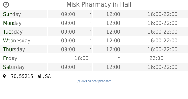
Misk Pharmacy
70, Hail
Pharmacy
read more
1.346 km
صيدلية
Unnamed Road،, Hail
Pharmacy
read more
1.424 km
صيدلية الدواء
Hail
Pharmacy
read more
1.542 km
Family Pharmacy
Hail
Pharmacy
read more
1.736 km
صيدلية الدوائية
Hail
Pharmacy
read more
1.759 km
صيدلية شمس الصحه
King Fahd Road, Hail
Pharmacy
read more
1.765 km
صيدلية زاد الدوائية 10
حائل
Pharmacy
read more
1.779 km
صيدلية الدواء
شارع الأمير سعود بن عبدالمحسن آل سعود, Hail
Pharmacy
read more
1.842 km
صيدلية الدواء
دوار الشهداء 7459،, Hail
Pharmacy
read more
1.847 km
pharmacy صيدلية زاد الدوائية
حائل
Pharmacy
read more
1.957 km
صيدلية سلامات
King Fahd Road, Hail
Pharmacy
read more
2.397 km
صيدلية الدواء البلاتيني
Hail
Pharmacy
read more
2.43 km
Almas Pharmacy 2
8236, Hail
Pharmacy
read more
2.523 km
Pharmacy recipe
Hail
Pharmacy
read more
2.7 km
Family Pharmacy
6588 فهد العلى العريفي, 2955, Hail
Pharmacy
read more
2.715 km
Al-Mass 7
Hail
Pharmacy
read more
3.025 km
صيدلية رابية الدواء
حائل
Pharmacy
read more
3.038 km
صيدلية الشفاء
6837 فهد العلى العريفي, 3242, Hail
Pharmacy
read more
3.874 km
صيدلية لمسات طبية
حائل
Pharmacy
read more
3.874 km
pharmacy صيدلية لمسات طبية
حائل
Pharmacy
read more
3.935 km
Al nahdi pharmacy
4205, Hail
Pharmacy
read more
4.356 km
صيدلية ياسر
7991 فهد العلى العريفي, Hail
Pharmacy
read more
4.996 km
Nahdi
8676 فهد العلى العريفي, 4400, Hail
Pharmacy
read more
📑
all categories
Accounting
Administrative area level 1
Airport
Amusement park
Aquarium
Art gallery
Atm
Bakery
Bank
Bar
Beauty salon
Bicycle store
Book store
Bowling alley
Bus station
Cafe
Campground
Car dealer
Car rental
Car repair
Car wash
Casino
Cemetery
Church
City hall
Clothing store
Colloquial area
Convenience store
Country
Courthouse
Dentist
Department store
Doctor
Electrician
Electronics store
Embassy
Finance
Fire station
Florist
Food
Funeral home
Furniture store
Gas station
General contractor
Grocery or supermarket
Gym
Hair care
Hardware store
Health
Hindu Temple
Home goods store
Hospital
Insurance agency
Intersection
Jewelry store
Laundry
Lawyer
Library
Light rail station
Liquor store
Local government office
Locality
Locksmith
Lodging
Meal delivery
Meal takeaway
Mosque
Movie rental
Movie theater
Moving company
Museum
Natural feature
Neighborhood
Night club
Painter
Park
Parking
Pet store
Pharmacy
Physiotherapist
Place of worship
Plumber
Point of interest
Police
Political
Post office
Premise
Real estate agency
Restaurant
Roofing contractor
Route
Rv park, camping
School
Shoe store
Shopping mall
Spa
Stadium
Storage
Store
Sublocality
Subpremise
Subway station
Supermarket
Taxi stand
Train station
Transit station
Travel agency
University
Veterinary care
Zoo
sublocality level 1
↑