Pharmacy nearby Ghadi Pharmacy
Saudi Arabia
Pharmacy nearby Ghadi Pharmacy
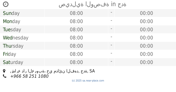
Ghadi Pharmacy
Mada'en Al-Fahd, Jeddah 22336, Saudi Arabia
contacts phone
:
+966 12 687 2935
Latitude:
21.4594411
, Longitude:
39.2260931
larger map & directions
read more
nearest Pharmacy
392 m
صيدلية طبابتي
مدائن الفهد، جدة
Pharmacy
read more
788 m
صيدلية مجمع هدير المدائن الطبي العام
عزة الإسلام، المدائن، جدة
Pharmacy
read more
913 m
Ammar Pharmacy
7307 Madain Al Fahd, حي مدائن الفهد, Jeddah
Pharmacy
read more
924 m
صيدلية نهضة الدواء
7277 Kannaz Ibn Al Husayn, 3360, Jeddah
Pharmacy
read more
926 m
AlWasfa Pharmacy
Abu Hudhayfah Ibn Utbah, Jeddah
Pharmacy
read more
935 m
United Pharmacy
7375 Madain Al Fahd, حي مدائن الفهد،, Jeddah
Pharmacy
read more
952 m
صيدلية الوسيلة
شارع كناز بن الحصين، مدائن الفهد، جدة
Pharmacy
read more
970 m
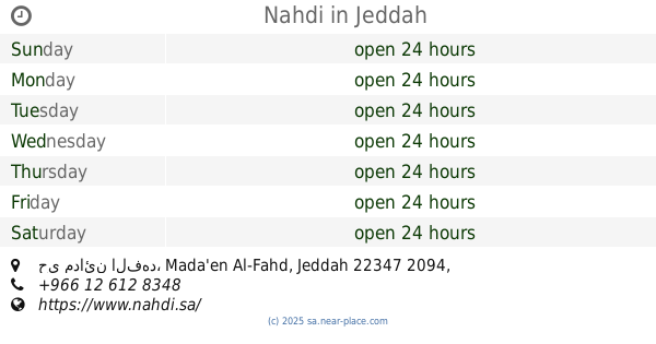
Nahdi
2126 Al Iskan, حي مدائن الفهد, Jeddah
Pharmacy
read more
1.043 km
AlWasfa Pharmacy
Umar Nasif, Jeddah
Pharmacy
read more
1.055 km
Nahdi
An Nuziah, Jeddah
Pharmacy
read more
1.055 km
Nahdi النهدي
An Nuziah, Jeddah
Pharmacy
read more
1.07 km
صيدلية الوصفة
شارع دار العروبة، حي مدائن الفهد، جدة
Pharmacy
read more
1.242 km
Wasfa Phermaci
Saad Ibn Ubayd, Jeddah
Pharmacy
read more
1.345 km
صيدلية المتحدة
شارع باب الوداع، حي النزلة الشرقية، جدة
Pharmacy
read more
1.349 km
صيدلية المتحدة 125
Jeddah
Pharmacy
read more
1.398 km
صيدلية مستوصف الشرق
حي النزلة، جدة
Pharmacy
read more
1.599 km
صيدلية ٤٨ (3)
4417, حي مدائن الفهد, Jeddah
Pharmacy
read more
1.641 km
Nahdi
4404 An Numan Ibn Bashir, حي مدائن الفهد, Jeddah
Pharmacy
read more
1.836 km
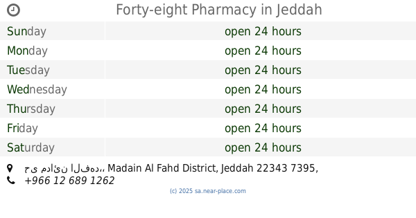
Forty-eight Pharmacy
4667, حي مدائن الفهد،, Jeddah
Pharmacy
read more
1.88 km
Nahdi
6589 Mohammed Fida, حي الثغر،, Jeddah
Pharmacy
read more
1.895 km
صيدلية فارما هوم
Jeddah
Pharmacy
read more
1.908 km
صيدلية فارما هوم
4747, حي مدائن الفهد،, Jeddah
Pharmacy
read more
1.992 km
صيدلية الوصفة ٤٢
Ibrahim An Nahrawani, Jeddah
Pharmacy
read more
1.999 km
صيدلية المستقبل
6707 Mohammed Fida, حي الثغر, Jeddah
Pharmacy
read more
2.004 km
Nahdi
6361, حي مدائن الفهد, Jeddah
Pharmacy
read more
📑
all categories
Accounting
Administrative area level 1
Airport
Amusement park
Aquarium
Art gallery
Atm
Bakery
Bank
Bar
Beauty salon
Bicycle store
Book store
Bowling alley
Bus station
Cafe
Campground
Car dealer
Car rental
Car repair
Car wash
Casino
Cemetery
Church
City hall
Clothing store
Colloquial area
Convenience store
Country
Courthouse
Dentist
Department store
Doctor
Electrician
Electronics store
Embassy
Finance
Fire station
Florist
Food
Funeral home
Furniture store
Gas station
General contractor
Grocery or supermarket
Gym
Hair care
Hardware store
Health
Hindu Temple
Home goods store
Hospital
Insurance agency
Intersection
Jewelry store
Laundry
Lawyer
Library
Light rail station
Liquor store
Local government office
Locality
Locksmith
Lodging
Meal delivery
Meal takeaway
Mosque
Movie rental
Movie theater
Moving company
Museum
Natural feature
Neighborhood
Night club
Painter
Park
Parking
Pet store
Pharmacy
Physiotherapist
Place of worship
Plumber
Point of interest
Police
Political
Post office
Premise
Real estate agency
Restaurant
Roofing contractor
Route
Rv park, camping
School
Shoe store
Shopping mall
Spa
Stadium
Storage
Store
Sublocality
Subpremise
Subway station
Supermarket
Taxi stand
Train station
Transit station
Travel agency
University
Veterinary care
Zoo
sublocality level 1
↑