Pharmacy nearby Nahdi النهدي
Saudi Arabia
Pharmacy nearby Nahdi النهدي
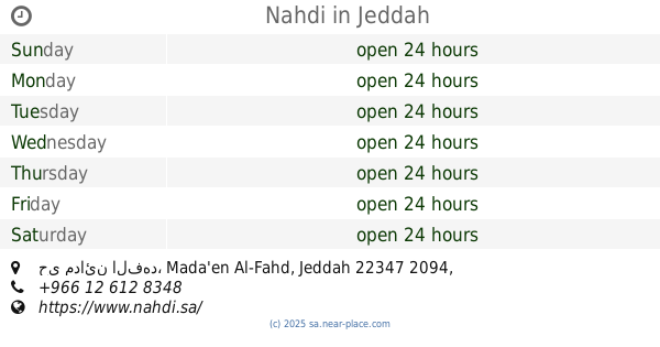
Nahdi النهدي
Mada'en Al-Fahd, Jeddah 22343, Saudi Arabia
contacts phone
:
+966 12 290 0729
website:
www.nahdi.sa
Latitude:
21.4617018
, Longitude:
39.2457785
larger map & directions
read more
nearest Pharmacy
129 m
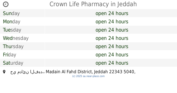
Crown Life Pharmacy
7226, حي مدائن الفهد،, Jeddah
Pharmacy
read more
211 m
صيدلية فارما هوم
4747, حي مدائن الفهد،, Jeddah
Pharmacy
read more
226 m
صيدلية فارما هوم
Jeddah
Pharmacy
read more
257 m
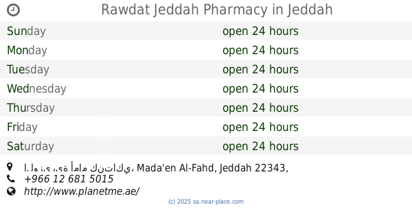
Rawdat Jeddah Pharmacy
الوزيرية أمام كنتاكي, Jeddah
Pharmacy
read more
263 m
صيدلية روضة جدة
شارع الفلاح، حي مدائن الفهد، جدة
Pharmacy
read more
304 m
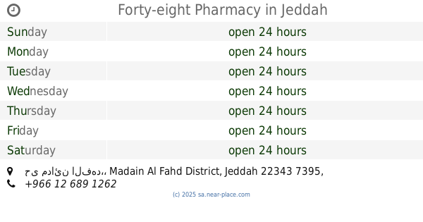
Forty-eight Pharmacy
4667, حي مدائن الفهد،, Jeddah
Pharmacy
read more
427 m
Nahdi
Al Umdah، جدة
Pharmacy
read more
427 m
Nahdi
Al Umdah, Jeddah
Pharmacy
read more
582 m
صيدلية ٤٨ (3)
4417, حي مدائن الفهد, Jeddah
Pharmacy
read more
620 m
Sudais Pharmacy ( Nahdi )
Jeddah
Pharmacy
read more
735 m
صيدلية التضامن
3560 Old Makkah Road, Jeddah
Pharmacy
read more
785 m
صيدلية الدواء جدة
2941, حي مدائن الفهد،, Jeddah
Pharmacy
read more
820 m
Nahdi
4404 An Numan Ibn Bashir, حي مدائن الفهد, Jeddah
Pharmacy
read more
924 m
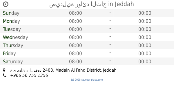
صيدلية روائد التاج
6522, حي مدائن الفهد 2403, Jeddah
Pharmacy
read more
958 m
Nahdi
Unnamed Road, Mada'en Al-Fahd, Jeddah
Pharmacy
read more
985 m
Nahdi
6361, حي مدائن الفهد, Jeddah
Pharmacy
read more
1.008 km
Nahdi
3161, حي مدائن الفهد 6931, Jeddah
Pharmacy
read more
1.063 km
مستودع النهضة
7284 Baghdad, Jeddah
Pharmacy
read more
1.114 km
صيدلية المتحدة بي
3667 احمد عاصم، جدة 22346
Pharmacy
read more
1.158 km
Wasfa Phermaci
Saad Ibn Ubayd, Jeddah
Pharmacy
read more
1.169 km
United Pharmacy
3862 Al Ansar, Jeddah
Pharmacy
read more
1.174 km
صيدلية جمعة السريحي
2743 Al Ansar, Jeddah
Pharmacy
read more
1.195 km
Western medicine pharmacy
7436 Baghdad, Jeddah
Pharmacy
read more
1.197 km
صيدلية مستقبل الصحة
6611 Bin Ladin, Jeddah
Pharmacy
read more
1.229 km
صيدلية السروات
3463 Old Makkah Road, Madain Al Fahd District,, Jeddah
Pharmacy
read more
📑
all categories
Accounting
Administrative area level 1
Airport
Amusement park
Aquarium
Art gallery
Atm
Bakery
Bank
Bar
Beauty salon
Bicycle store
Book store
Bowling alley
Bus station
Cafe
Campground
Car dealer
Car rental
Car repair
Car wash
Casino
Cemetery
Church
City hall
Clothing store
Colloquial area
Convenience store
Country
Courthouse
Dentist
Department store
Doctor
Electrician
Electronics store
Embassy
Finance
Fire station
Florist
Food
Funeral home
Furniture store
Gas station
General contractor
Grocery or supermarket
Gym
Hair care
Hardware store
Health
Hindu Temple
Home goods store
Hospital
Insurance agency
Intersection
Jewelry store
Laundry
Lawyer
Library
Light rail station
Liquor store
Local government office
Locality
Locksmith
Lodging
Meal delivery
Meal takeaway
Mosque
Movie rental
Movie theater
Moving company
Museum
Natural feature
Neighborhood
Night club
Painter
Park
Parking
Pet store
Pharmacy
Physiotherapist
Place of worship
Plumber
Point of interest
Police
Political
Post office
Premise
Real estate agency
Restaurant
Roofing contractor
Route
Rv park, camping
School
Shoe store
Shopping mall
Spa
Stadium
Storage
Store
Sublocality
Subpremise
Subway station
Supermarket
Taxi stand
Train station
Transit station
Travel agency
University
Veterinary care
Zoo
sublocality level 1
↑