Pharmacy nearby Sramik Aljyoda
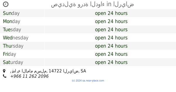
Saudi Arabia
Pharmacy nearby Sramik Aljyoda
Sramik Aljyoda
Unnamed Road، Al Marwah, Riyadh 14722, Saudi Arabia
contacts phone
:
+966
Latitude:
24.5404017
, Longitude:
46.6783514
larger map & directions
read more
nearest Pharmacy
988 m
صيدلية وردة الدواء
شارع الإمام مسلم، الرياض
Pharmacy
read more
1.103 km
Greens pharmacy صيدليه جرينز
طريق ابن تيمية, Riyadh
Pharmacy
read more
1.214 km
الجازع
7139 Muhammad Ibn Hamad Abu Shaibah, Riyadh
Pharmacy
read more
1.22 km
AROOBA MEDICAL SHIFA.
4043 القادسية, Riyadh
Pharmacy
read more
1.22 km
AROOBA MEDICAL SHIFA.
4043 القادسية، الرياض
Pharmacy
read more
1.227 km
Aljazea Pharmacy
7139 Muhammad Ibn Hamad Abu Shaibah, Riyadh
Pharmacy
read more
1.249 km
Nahdi
Ibn Taymeeyah Road, Riyadh
Pharmacy
read more
1.261 km
Nahdi
الخليل بن أحمد، المروة،, Riyadh
Pharmacy
read more
1.262 km
Liali Alseha Pharmacy (1)
شارع قرطاجة، بدر، الرياض
Pharmacy
read more
1.262 km
Liali Alseha Pharmacy (1)
8364, 14725, Riyadh
Pharmacy
read more
1.268 km
Nahdi
شارع الخليل بن احمد، الرياض
Pharmacy
read more
1.293 km
Pharmacy Drug rack
Al Imam Muslim Road Branch, Riyadh
Pharmacy
read more
1.317 km
صيدلية زهرة الروضة
Al Khalil Ibn Ahmad, Riyadh
Pharmacy
read more
1.323 km
Arabism Pharmacy
2873 ابراهيم الدهان، الرياض
Pharmacy
read more
1.331 km
Arabism Pharmacy
2873 Ibrahim Ad Dahan, Riyadh
Pharmacy
read more
1.366 km
صيدلية بوينت
Ibn Taymeeyah Road, Riyadh
Pharmacy
read more
1.422 km
صيدلية Plus one
Riyadh
Pharmacy
read more
1.449 km
Zahrat Aleshrag Pharmacy
6150 Dirab Branch Road, Riyadh
Pharmacy
read more
1.45 km
صيدلية بيت المدائن
Dirab Road, Riyadh
Pharmacy
read more
1.45 km
صيدلية بيت المدائن
طريق ديراب، الرياض
Pharmacy
read more
1.471 km
Pharmacy
Bat'ha Street, Dammam
Pharmacy
read more
1.518 km
صيدلية صفوة العلاج
Qartajah, Riyadh
Pharmacy
read more
1.649 km
Drug Pharmacy
7801 2538 Ibn Taymeeyah Road, Riyadh
Pharmacy
read more
1.667 km
صيدلية دوائي
Dirab Road, Riyadh
Pharmacy
read more
1.863 km
Al-Dawaa
7425 14722 2139 طريق ديراب الفرعي، المروة، الرياض
Pharmacy
read more
📑
all categories
Accounting
Administrative area level 1
Airport
Amusement park
Aquarium
Art gallery
Atm
Bakery
Bank
Bar
Beauty salon
Bicycle store
Book store
Bowling alley
Bus station
Cafe
Campground
Car dealer
Car rental
Car repair
Car wash
Casino
Cemetery
Church
City hall
Clothing store
Colloquial area
Convenience store
Country
Courthouse
Dentist
Department store
Doctor
Electrician
Electronics store
Embassy
Finance
Fire station
Florist
Food
Funeral home
Furniture store
Gas station
General contractor
Grocery or supermarket
Gym
Hair care
Hardware store
Health
Hindu Temple
Home goods store
Hospital
Insurance agency
Intersection
Jewelry store
Laundry
Lawyer
Library
Light rail station
Liquor store
Local government office
Locality
Locksmith
Lodging
Meal delivery
Meal takeaway
Mosque
Movie rental
Movie theater
Moving company
Museum
Natural feature
Neighborhood
Night club
Painter
Park
Parking
Pet store
Pharmacy
Physiotherapist
Place of worship
Plumber
Point of interest
Police
Political
Post office
Premise
Real estate agency
Restaurant
Roofing contractor
Route
Rv park, camping
School
Shoe store
Shopping mall
Spa
Stadium
Storage
Store
Sublocality
Subpremise
Subway station
Supermarket
Taxi stand
Train station
Transit station
Travel agency
University
Veterinary care
Zoo
sublocality level 1
↑