Pharmacy nearby صيدلية وجدان
Saudi Arabia
Pharmacy nearby صيدلية وجدان
صيدلية وجدان
حي الهميلة، خميس مشيط Saudi Arabia
contacts phone
:
+966
Latitude:
18.3093353
, Longitude:
42.721059
read more
nearest Pharmacy
611 m
Anwar Asir
4868 King Abdullah Road, 4955, Khamis Mushait
Pharmacy
read more
781 m
صيدلية فجرالنهضة
وسط البلد، خميس مشيط
Pharmacy
read more
837 m
صيدلية المتحدة
Khamis Mushait
Pharmacy
read more
871 m
Nahdi
King Fahd Road, Khamis Mushait
Pharmacy
read more
878 m
صيدلية عثمان غرم العمري
بجوار مجمع هدوء الطبي- حي الخالدية، خميس مشيط
Pharmacy
read more
882 m
Pharmacy FAO
King Fahd Road, Khamis Mushait
Pharmacy
read more
925 m
صيدلية الغربية البيطرية
حي البلد، خميس مشيط
Pharmacy
read more
927 m
صيدلية العسيري البيطرية
9260, Khamis Mushait
Pharmacy
read more
952 m
Pharmacy Corner savings
6707 عمر بن الخطاب، شباعة، خميس مشيط 62458 4000 Umar Ibn Al Khattab, Khamis Mushait
Pharmacy
read more
955 m
صيدلية الخليج البيطرية
9201, Khamis Mushait
Pharmacy
read more
955 m
صيدلية العسيري البيطرية
9237, Khamis Mushait
Pharmacy
read more
987 m
Nahdi
شارع الملك عبدالله، خميس مشيط
Pharmacy
read more
1.043 km
Pharmacy Hassania
شارع الثلاثين، حي الخالدية، خميس مشيط
Pharmacy
read more
1.061 km
صيدلية الحسنية الكبرى
الخالدية،, Khamis Mushait
Pharmacy
read more
1.064 km
صيدلية تعافي
وسط المدينة، خميس مشيط
Pharmacy
read more
1.092 km
Nahdi
King Faysal Road, Khamis Mushait
Pharmacy
read more
1.23 km
صيدلية ناصر ضيف الله مريع
شارع ورقه بن نوفل، حي شباعة، خميس مشيط
Pharmacy
read more
1.569 km
Nahdi
طريق الملك خالد, Khamis Mushait
Pharmacy
read more
1.628 km
صيدلية
عتود
Pharmacy
read more
1.671 km
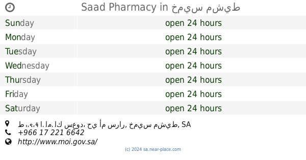
Saad Pharmacy
طريق الملك سعود، حي أم سرار، خميس مشيط
Pharmacy
read more
1.697 km
Pharmacy Al-Khamis
Khamis Mushait
Pharmacy
read more
1.699 km
صيدلية الاسرة الشاملة
4078, Khamis Mushait
Pharmacy
read more
1.712 km
Sultan Pharmacy 1
Khamis Mushait
Pharmacy
read more
1.716 km
Dan Pharmacy (Nahdi)
15, Khamis Mushait
Pharmacy
read more
1.718 km
Comprehensive family compound Clinics
Khamis Mushait
Pharmacy
read more
📑
all categories
Accounting
Administrative area level 1
Airport
Amusement park
Aquarium
Art gallery
Atm
Bakery
Bank
Bar
Beauty salon
Bicycle store
Book store
Bowling alley
Bus station
Cafe
Campground
Car dealer
Car rental
Car repair
Car wash
Casino
Cemetery
Church
City hall
Clothing store
Colloquial area
Convenience store
Country
Courthouse
Dentist
Department store
Doctor
Electrician
Electronics store
Embassy
Finance
Fire station
Florist
Food
Funeral home
Furniture store
Gas station
General contractor
Grocery or supermarket
Gym
Hair care
Hardware store
Health
Hindu Temple
Home goods store
Hospital
Insurance agency
Intersection
Jewelry store
Laundry
Lawyer
Library
Light rail station
Liquor store
Local government office
Locality
Locksmith
Lodging
Meal delivery
Meal takeaway
Mosque
Movie rental
Movie theater
Moving company
Museum
Natural feature
Neighborhood
Night club
Painter
Park
Parking
Pet store
Pharmacy
Physiotherapist
Place of worship
Plumber
Point of interest
Police
Political
Post office
Premise
Real estate agency
Restaurant
Roofing contractor
Route
Rv park, camping
School
Shoe store
Shopping mall
Spa
Stadium
Storage
Store
Sublocality
Subpremise
Subway station
Supermarket
Taxi stand
Train station
Transit station
Travel agency
University
Veterinary care
Zoo
sublocality level 1
↑