Point of interest nearby Dania Gas
Saudi Arabia
Point of interest nearby Dania Gas
Dania Gas
7355, مخطط الزهور،, Sakaka Arabia Saudyjska
contacts phone
:
+966
Latitude:
29.9251828
, Longitude:
40.2055061
read more
nearest Point of interest
415 m
Star Insurance Services Company
8830 طريق الملك عبدالله بن عبدالعزيز, المحمدية م 5129, Sakaka
Point of interest
read more
456 m
Office Dar Real Estate
8770 طريق الملك عبدالله بن عبدالعزيز, المحمدية م, Sakaka
Point of interest
read more
485 m
Freeh Office of the property and installment
الامام محمد بن سعود, Sakaka
Point of interest
read more
617 m
مستودع شركة صناعة الاغذية المتحدة (بسكويت ديمه) - السكاكا
7079 طريق الملك عبدالله بن عبدالعزيز, AZ Zuhur Subdivision, Sakaka
Point of interest
read more
720 m
مصنع الهفوف للرفوف
6846 طريق الملك خالد، مخطط الزهور سكاكا 72342 2191 طريق الملك خالد, Sakaka
Point of interest
read more
732 m
Muncipality Of Jouf Workshop Keraj
7476 طريق الامير نايف بن عبدالعزيز, 3418, Sakaka
Point of interest
read more
774 m
مكتب العطيفي للعقارات
سكاكا
Point of interest
read more
792 m
مؤسسة الإنماء الماسي للمقاولات
Sakaka
Point of interest
read more
909 m
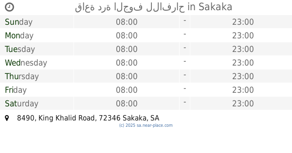
قاعة درة الجوف للافراح
8490 King Khalid Road, Sakaka
Point of interest
read more
911 m
قصر أفراح درة الجوف للإحتفالات
8490 طريق الملك خالد, Sakaka
Point of interest
read more
956 m
ناريز للاحتفالات
Unnamed Road, Sakaka
Point of interest
read more
966 m
مكتب الدكتور أحمد فريد مصطفى للاستشارات الهندسية
طريق الملك خالد -الحزام, Sakaka
Point of interest
read more
988 m
شركة ابداع الامان للحراسات الامنية
King Khaled Road, Sakaka
Point of interest
read more
1.008 km
استراحة ناريز
Sakaka
Point of interest
read more
1.017 km
Imanco Sakaka Al Juof
الامير فيصل بن فهد الامير فيصل بن فهد, Al Muhammadiyah G, Sakaka
Point of interest
read more
📑
all categories
Accounting
Administrative area level 1
Airport
Amusement park
Aquarium
Art gallery
Atm
Bakery
Bank
Bar
Beauty salon
Bicycle store
Book store
Bowling alley
Bus station
Cafe
Campground
Car dealer
Car rental
Car repair
Car wash
Casino
Cemetery
Church
City hall
Clothing store
Colloquial area
Convenience store
Country
Courthouse
Dentist
Department store
Doctor
Electrician
Electronics store
Embassy
Finance
Fire station
Florist
Food
Funeral home
Furniture store
Gas station
General contractor
Grocery or supermarket
Gym
Hair care
Hardware store
Health
Hindu Temple
Home goods store
Hospital
Insurance agency
Intersection
Jewelry store
Laundry
Lawyer
Library
Light rail station
Liquor store
Local government office
Locality
Locksmith
Lodging
Meal delivery
Meal takeaway
Mosque
Movie rental
Movie theater
Moving company
Museum
Natural feature
Neighborhood
Night club
Painter
Park
Parking
Pet store
Pharmacy
Physiotherapist
Place of worship
Plumber
Point of interest
Police
Political
Post office
Premise
Real estate agency
Restaurant
Roofing contractor
Route
Rv park, camping
School
Shoe store
Shopping mall
Spa
Stadium
Storage
Store
Sublocality
Subpremise
Subway station
Supermarket
Taxi stand
Train station
Transit station
Travel agency
University
Veterinary care
Zoo
sublocality level 1
↑