Point of interest nearby مكتب الوسام الافضل للإستقدام
Saudi Arabia
Point of interest nearby مكتب الوسام الافضل للإستقدام
مكتب الوسام الافضل للإستقدام
شارع الأمير ماجد، الربوة، جدة Saudi Arabien
contacts phone
:
+966
Latitude:
21.6114515
, Longitude:
39.187355
read more
nearest Point of interest
325 m
إستوديو الوسام
شارع عبدالله ذي البجادين، حي الربوة، جدة
Point of interest
read more
514 m
Support and facilities for safety systems
7683 أنس بن أوس, Jeddah
Point of interest
read more
585 m
Qasr Al Ahd 2
Yahya Al Mualimi, Jeddah
Point of interest
read more
694 m
مكتب رحلة سعيدة - Rehlah Saeeda
2658 Al Haydari, Al Marwah District, Jeddah
Point of interest
read more
697 m
NaqelExpress
Prince Majid Rd, Jeddah
Point of interest
read more
771 m
الأبراج للسقالات
شارع الثلاثين - حي الربوه، جدة
Point of interest
read more
901 m
Al Sagr Cooperative
Al Makarunah Branch, Jeddah
Point of interest
read more
910 m
Kingdom of Doctors
Abi Habib Al Ansari, Jeddah
Point of interest
read more
969 m
دهب كلين لاعمال السباكة
الانقري، المروة،, Jeddah
Point of interest
read more
992 m
Sadliya jamal . Jamal medical store
Road 30, طريق المكرونة, with, Jeddah
Point of interest
read more
1.035 km
SAPTCO drivers housing
6872 Al Amir Mitib Al Marwah District Jeddah 23541
Point of interest
read more
1.128 km
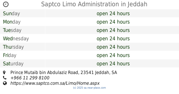
Saptco Limo Administration
Prince Mutaib bin Abdulaziz Road, 6722 Prince Mutaib bin Abdulaziz Rd, Al Marwah District Jeddah 23541 3597
Point of interest
read more
1.138 km
معرض السعد للحدادة والألمنيوم
شارع المكرونه حي الربوه، جدة
Point of interest
read more
1.22 km
مشغل الخنساء
شارع الزجاجي - المروة، جدة
Point of interest
read more
1.225 km
Tolips Flowers توليب للزهور
Prince Mutaib bin Abdulaziz Road, Hira St, مع Hira Street with the Forty Street تقاطع, Jeddah
Point of interest
read more
📑
all categories
Accounting
Administrative area level 1
Airport
Amusement park
Aquarium
Art gallery
Atm
Bakery
Bank
Bar
Beauty salon
Bicycle store
Book store
Bowling alley
Bus station
Cafe
Campground
Car dealer
Car rental
Car repair
Car wash
Casino
Cemetery
Church
City hall
Clothing store
Colloquial area
Convenience store
Country
Courthouse
Dentist
Department store
Doctor
Electrician
Electronics store
Embassy
Finance
Fire station
Florist
Food
Funeral home
Furniture store
Gas station
General contractor
Grocery or supermarket
Gym
Hair care
Hardware store
Health
Hindu Temple
Home goods store
Hospital
Insurance agency
Intersection
Jewelry store
Laundry
Lawyer
Library
Light rail station
Liquor store
Local government office
Locality
Locksmith
Lodging
Meal delivery
Meal takeaway
Mosque
Movie rental
Movie theater
Moving company
Museum
Natural feature
Neighborhood
Night club
Painter
Park
Parking
Pet store
Pharmacy
Physiotherapist
Place of worship
Plumber
Point of interest
Police
Political
Post office
Premise
Real estate agency
Restaurant
Roofing contractor
Route
Rv park, camping
School
Shoe store
Shopping mall
Spa
Stadium
Storage
Store
Sublocality
Subpremise
Subway station
Supermarket
Taxi stand
Train station
Transit station
Travel agency
University
Veterinary care
Zoo
sublocality level 1
↑