Restaurant nearby فوال وج الطائف
Saudi Arabia
Restaurant nearby فوال وج الطائف
فوال وج الطائف
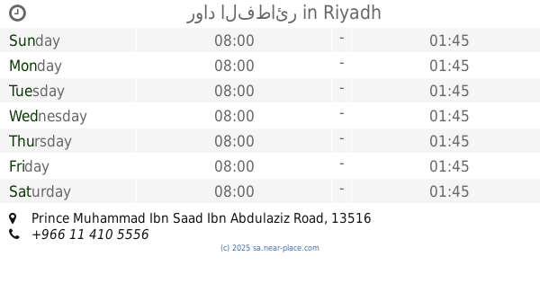
Al Tahliyah Street, 13515, Riyadh, SA Saudi Arabia
contacts phone
:
+966
Latitude:
24.7793267
, Longitude:
46.6225997
larger map & directions
read more
nearest Restaurant
396 m
STOER MZOEN
شارع التحلية، العقيق،, Riyadh
Restaurant
read more
628 m
B1 Burger
Al Tahliyah Street, Riyadh
Restaurant
read more
630 m
مطعم زمزم البلاد البخاري
Al Tahliyah Street, Riyadh
Restaurant
read more
630 m
مطعم رواد الفطائر
7752 Prince Muhammad Ibn Saad Ibn Abdulaziz Road, Riyadh
Restaurant
read more
631 m
رواد الفطائر
Prince Muhammad Ibn Saad Ibn Abdulaziz Road, Riyadh
Restaurant
read more
637 m
Bbq
As Sulaimaniyah Street, Riyadh
Restaurant
read more
647 m
فوال حمد الدوسري
6517 Prince Muhammad Ibn Saad Ibn Abdulaziz Road, Riyadh
Restaurant
read more
662 m
فلافل خبز على الصاج
Riyadh
Restaurant
read more
748 m
Medina Restaurant Pakistani Indian Food
6774 Al Bahar Al Mutawassit, Al Aqiq, Riyadh 13515 3692 Al Bahar Al Mutawassit, Riyadh
Restaurant
read more
754 m
صندوق البروستد broasted box
6746 Al Bahar Al Mutawassit Al Aqiq Riyadh 13515 3706 Al Bahar Al Mutawassit, Riyadh
Restaurant
read more
762 m
Pies Abdulaziz
6746 البحر المتوسط، العقيق الرياض 13515 3706 Al Bahar Al Mutawassit, Riyadh
Restaurant
read more
1.114 km
دجاج كنتاكي
7463 طريق الأمير محمد بن سعد بن عبدالعزيز، العقيق الرياض 13515 2226 Prince Muhammad Ibn Saad Ibn Abdulaziz Road, Riyadh
Restaurant
read more
1.114 km
KFC
7463 طريق الأمير محمد بن سعد بن عبدالعزيز، العقيق الرياض 13515 2226 Prince Muhammad Ibn Saad Ibn Abdulaziz Road, Riyadh
Restaurant
read more
1.143 km
Hardee's
khair rd., Riyadh
Restaurant
read more
1.222 km
مطعم البخاري
2189 Imam Saud Bin Faisal Rd, Al Aqiq Riyadh 13515 7845 Imam Saud Bin Faisal Road, Riyadh
Restaurant
read more
📑
all categories
Accounting
Administrative area level 1
Airport
Amusement park
Aquarium
Art gallery
Atm
Bakery
Bank
Bar
Beauty salon
Bicycle store
Book store
Bowling alley
Bus station
Cafe
Campground
Car dealer
Car rental
Car repair
Car wash
Casino
Cemetery
Church
City hall
Clothing store
Colloquial area
Convenience store
Country
Courthouse
Dentist
Department store
Doctor
Electrician
Electronics store
Embassy
Finance
Fire station
Florist
Food
Funeral home
Furniture store
Gas station
General contractor
Grocery or supermarket
Gym
Hair care
Hardware store
Health
Hindu Temple
Home goods store
Hospital
Insurance agency
Intersection
Jewelry store
Laundry
Lawyer
Library
Light rail station
Liquor store
Local government office
Locality
Locksmith
Lodging
Meal delivery
Meal takeaway
Mosque
Movie rental
Movie theater
Moving company
Museum
Natural feature
Neighborhood
Night club
Painter
Park
Parking
Pet store
Pharmacy
Physiotherapist
Place of worship
Plumber
Point of interest
Police
Political
Post office
Premise
Real estate agency
Restaurant
Roofing contractor
Route
Rv park, camping
School
Shoe store
Shopping mall
Spa
Stadium
Storage
Store
Sublocality
Subpremise
Subway station
Supermarket
Taxi stand
Train station
Transit station
Travel agency
University
Veterinary care
Zoo
sublocality level 1
↑