Restaurant nearby مطعم المزرعة
Saudi Arabia
Restaurant nearby مطعم المزرعة
مطعم المزرعة
Al Mathari, 12755, Riyadh, SA Saudi Arabia
contacts phone
:
+966 11 434 0804
Latitude:
24.6145811
, Longitude:
46.6702236
larger map & directions
read more
nearest Restaurant
894 m
مؤسسة ميقات المدن بوفية
طريق المدينة المنورة ، ظهرة البديعة، الرياض
Restaurant
read more
1.003 km
مطعم بوادي نجد
Al Madinah Al Munawwarah Road, Riyadh
Restaurant
read more
1.108 km
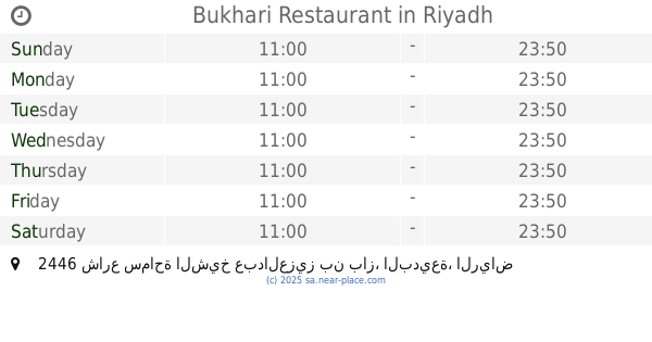
Bukhari Restaurant
2446 شارع سماحة الشيخ عبدالعزيز بن باز، البديعة، الرياض 12746 6838 Samahat Ash Shaikh Abdulaziz Ibn Baz Street, Riyadh
Restaurant
read more
1.157 km
مطاعم بحرية البديعة
2446 Samahat Ash Shaikh Abdulaziz Ibn Baz Street, Saudi, Riyadh
Restaurant
read more
1.157 km
مطاعم بحرية - Bahrya
2446 Samahat Ash Shaikh Abdulaziz Ibn Baz Street, Saudi, Riyadh
Restaurant
read more
1.162 km
مطاعم بحرية - Bahrya
2446 Samahat Ash Shaikh Abdulaziz Ibn Baz Street, Riyadh
Restaurant
read more
1.177 km
Falafel Arafa
2523 Samahat Ash Shaikh Abdulaziz Ibn Baz St Al Badi'ah Riyadh 12748 6807 Samahat Ash Shaikh Abdulaziz Ibn Baz Street, Riyadh
Restaurant
read more
1.651 km
Pizza Hut
Samahat Ash Shaikh Abdul Aziz Ibn Baz، الرياض
Restaurant
read more
1.786 km
مطعم البخاري
سماحة الشيخ عبدالعزيز بن باز، الشميسي، الرياض
Restaurant
read more
2.036 km
Soltana Fish اسماك سلطانة
3942 Sultanah, Riyadh 12772 7325 Sultanah, Riyadh
Restaurant
read more
2.115 km
Pasalubong Restaurant
7124 Said Ibn Qays Al Badi'ah Riyadh 12747 3404 Said Ibn Qays, Riyadh
Restaurant
read more
2.342 km
هامبرغيني
Riyadh
Restaurant
read more
2.453 km
مشويات عبد العزيز
3714 As Suwaidi Al Am, Riyadh
Restaurant
read more
2.457 km
كبدة على الصاج
شارع السويدي ، السويدي، الرياض
Restaurant
read more
2.585 km
فاطمة عبدالعزيزعبدالله الحمادي للوجبات السريعة
شارع السويدي، السويدي، الرياض
Restaurant
read more
📑
all categories
Accounting
Administrative area level 1
Airport
Amusement park
Aquarium
Art gallery
Atm
Bakery
Bank
Bar
Beauty salon
Bicycle store
Book store
Bowling alley
Bus station
Cafe
Campground
Car dealer
Car rental
Car repair
Car wash
Casino
Cemetery
Church
City hall
Clothing store
Colloquial area
Convenience store
Country
Courthouse
Dentist
Department store
Doctor
Electrician
Electronics store
Embassy
Finance
Fire station
Florist
Food
Funeral home
Furniture store
Gas station
General contractor
Grocery or supermarket
Gym
Hair care
Hardware store
Health
Hindu Temple
Home goods store
Hospital
Insurance agency
Intersection
Jewelry store
Laundry
Lawyer
Library
Light rail station
Liquor store
Local government office
Locality
Locksmith
Lodging
Meal delivery
Meal takeaway
Mosque
Movie rental
Movie theater
Moving company
Museum
Natural feature
Neighborhood
Night club
Painter
Park
Parking
Pet store
Pharmacy
Physiotherapist
Place of worship
Plumber
Point of interest
Police
Political
Post office
Premise
Real estate agency
Restaurant
Roofing contractor
Route
Rv park, camping
School
Shoe store
Shopping mall
Spa
Stadium
Storage
Store
Sublocality
Subpremise
Subway station
Supermarket
Taxi stand
Train station
Transit station
Travel agency
University
Veterinary care
Zoo
sublocality level 1
↑