School nearby ابتدائية سراقة بن مالك بحي العسيلة
Saudi Arabia
School nearby ابتدائية سراقة بن مالك بحي العسيلة
ابتدائية سراقة بن مالك بحي العسيلة
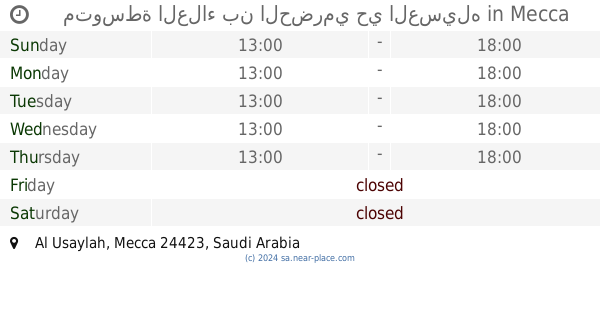
3156, Al Usaylah, Mecca 24423 6535, Saudi Arabia
contacts phone
:
+966
Latitude:
21.4936728
, Longitude:
39.8786592
larger map & directions
read more
nearest School
41 m
Secondary Sufyan bin Auf neighborhood boys Alasilh
3133, Mecca
School
read more
50 m
مدرسھ الناصر الآبتدائی
Mecca
School
read more
57 m
متوسطة العلاء بن الحضرمي حي العسيله
Mecca
School
read more
973 m
Secondary Imam Alexaii neighborhood boys Alasilh
Mecca
School
read more
998 m
مدرسة سفيان بن عوف الثانوية
Mecca
School
read more
1.032 km
Abdulrahman Al-Nasser Elementary School
Unnamed Road, Mecca
School
read more
1.046 km
المتوسطة السادسة والستون للبنات
Mecca
School
read more
1.051 km
Dar Al Hedaya Koranic
Mecca
School
read more
1.058 km
مدرسة
Mecca
School
read more
1.074 km
المتوسطه 66 مكه والابتدائيه 59
Mecca
School
read more
1.087 km
ابتدائية عبدالرحمن الناصر بنين حي العسيلة
Mecca
School
read more
1.265 km
الابتدائية 34 و روضة الحكمة
مكة
School
read more
1.273 km
روضة الحكمة بالعسيلة
Mecca
School
read more
1.275 km
مجمع العسيلة التعليمي للبنات ( co4 ) روضة وجميع المراحل
Mecca
School
read more
1.324 km
Kindergarten generation capacity Nabg
Mecca
School
read more
1.379 km
66 medium
Mecca
School
read more
1.379 km
روضة الجيل النابغ
Al Aseelh
School
read more
1.667 km
Thirty-fourth school
Unnamed Road,, Mecca
School
read more
3.62 km
متوسطة
Mecca
School
read more
3.628 km
مدرسة وكيع بن الجراح المتوسطة
Mecca
School
read more
3.644 km
مدرسة ابن زيدون الابتدائية
طريق المعيصم, Mecca
School
read more
3.644 km
مدرسة ابن زيدون للبنين.
طريق المعيصم, Mecca
School
read more
3.669 km
Hajjaj bin Yusuf Elementary School
4831, Mecca
School
read more
3.926 km
متوسطة عصماء بنت الحارث
7733, Mecca
School
read more
4.033 km
Secondary Ikrima ibn Abi Jahl
Al Hajj, Mecca
School
read more
📑
all categories
Accounting
Administrative area level 1
Airport
Amusement park
Aquarium
Art gallery
Atm
Bakery
Bank
Bar
Beauty salon
Bicycle store
Book store
Bowling alley
Bus station
Cafe
Campground
Car dealer
Car rental
Car repair
Car wash
Casino
Cemetery
Church
City hall
Clothing store
Colloquial area
Convenience store
Country
Courthouse
Dentist
Department store
Doctor
Electrician
Electronics store
Embassy
Finance
Fire station
Florist
Food
Funeral home
Furniture store
Gas station
General contractor
Grocery or supermarket
Gym
Hair care
Hardware store
Health
Hindu Temple
Home goods store
Hospital
Insurance agency
Intersection
Jewelry store
Laundry
Lawyer
Library
Light rail station
Liquor store
Local government office
Locality
Locksmith
Lodging
Meal delivery
Meal takeaway
Mosque
Movie rental
Movie theater
Moving company
Museum
Natural feature
Neighborhood
Night club
Painter
Park
Parking
Pet store
Pharmacy
Physiotherapist
Place of worship
Plumber
Point of interest
Police
Political
Post office
Premise
Real estate agency
Restaurant
Roofing contractor
Route
Rv park, camping
School
Shoe store
Shopping mall
Spa
Stadium
Storage
Store
Sublocality
Subpremise
Subway station
Supermarket
Taxi stand
Train station
Transit station
Travel agency
University
Veterinary care
Zoo
sublocality level 1
↑