School nearby الابتدائية السابعة والاربعون
Saudi Arabia
School nearby الابتدائية السابعة والاربعون
الابتدائية السابعة والاربعون
Al Khraimi, Hail 55426, Arabia Saudyjska
contacts phone
:
+966 16 543 7205
Latitude:
27.5112391
, Longitude:
41.7208379
larger map & directions
read more
nearest School
19 m
كلية المجتمع
Hail
School
read more
816 m
مدرسة ثانوية المهاجرون
7259, Hail
School
read more
901 m
مدرسة الإبتدائية ٣٨ بنات
4615 عقبة بن نافع, 7077, Hail
School
read more
912 m
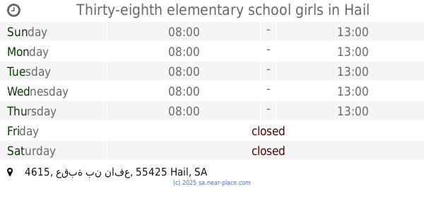
Thirty-eighth elementary school girls
4615 عقبة بن نافع, Hail
School
read more
940 m
مجمع مدارس بنات
Hail
School
read more
946 m
متوسطة التاسعة والعشرون بنات
Hail
School
read more
969 m
الثانوية الرابعة عشر بنات
4615 عقبة بن نافع, Hail
School
read more
987 m
الروضة الخامسة والعشرون
School
read more
995 m
Forty four elementary girls
4667, Hail
School
read more
995 m
الثانوية الرابعة عشر بنات بحائل
4667, Hail
School
read more
1.039 km
مدرسة الابتدائيه التحفيظ السادسة
Hail
School
read more
1.041 km
المحبرة للكتب المستعملة
Alnaam Street, محطة, Hail
School
read more
1.184 km
Imam Muslim elementary school
Hail
School
read more
1.346 km
إبتداية تحفيظ القرآن الكريم
حائل
School
read more
1.408 km
Elementary school four o'clock
7959, Hail
School
read more
1.408 km
ابتدائية سعد بن معاذ
4963, Hail
School
read more
1.43 km
مدرسة إبن قدامة للبنين
Asir, Hail
School
read more
1.431 km
Secondary Hira
Asir, Hail
School
read more
1.456 km
الابتدائية الرابعة للبنات
Unnamed Road, Hail
School
read more
1.469 km
Medium Ibn Hisham
Asir, Hail
School
read more
1.473 km
ابتدائية الفيصلية
Labdah
School
read more
1.483 km
متوسطة الإمام حفص
6595, Hail
School
read more
1.543 km
المدرسة الاولى المتوسطة(بنات)
9002-8968, Hail
School
read more
1.554 km
Mecca Intermediate School
Ar Riyadh, Hail
School
read more
1.598 km
الابتدائية الحادية والثلاثون
حائل
School
read more
📑
all categories
Accounting
Administrative area level 1
Airport
Amusement park
Aquarium
Art gallery
Atm
Bakery
Bank
Bar
Beauty salon
Bicycle store
Book store
Bowling alley
Bus station
Cafe
Campground
Car dealer
Car rental
Car repair
Car wash
Casino
Cemetery
Church
City hall
Clothing store
Colloquial area
Convenience store
Country
Courthouse
Dentist
Department store
Doctor
Electrician
Electronics store
Embassy
Finance
Fire station
Florist
Food
Funeral home
Furniture store
Gas station
General contractor
Grocery or supermarket
Gym
Hair care
Hardware store
Health
Hindu Temple
Home goods store
Hospital
Insurance agency
Intersection
Jewelry store
Laundry
Lawyer
Library
Light rail station
Liquor store
Local government office
Locality
Locksmith
Lodging
Meal delivery
Meal takeaway
Mosque
Movie rental
Movie theater
Moving company
Museum
Natural feature
Neighborhood
Night club
Painter
Park
Parking
Pet store
Pharmacy
Physiotherapist
Place of worship
Plumber
Point of interest
Police
Political
Post office
Premise
Real estate agency
Restaurant
Roofing contractor
Route
Rv park, camping
School
Shoe store
Shopping mall
Spa
Stadium
Storage
Store
Sublocality
Subpremise
Subway station
Supermarket
Taxi stand
Train station
Transit station
Travel agency
University
Veterinary care
Zoo
sublocality level 1
↑